Country:
Region:
City:
Latitude and Longitude:
Time Zone:
Postal Code:
IP information under different IP Channel
ip-api
Country
Region
City
ASN
Time Zone
ISP
Blacklist
Proxy
Latitude
Longitude
Postal
Route
Luminati
Country
ASN
Time Zone
Asia/Jakarta
ISP
PT. NTT Indonesia
Latitude
Longitude
Postal
IPinfo
Country
Region
City
ASN
Time Zone
ISP
Blacklist
Proxy
Latitude
Longitude
Postal
Route
db-ip
Country
Region
City
ASN
Time Zone
ISP
Blacklist
Proxy
Latitude
Longitude
Postal
Route
ipdata
Country
Region
City
ASN
Time Zone
ISP
Blacklist
Proxy
Latitude
Longitude
Postal
Route
Popular places and events near this IP address

Wisma 46
Skyscraper in Jakarta, Indonesia
Distance: Approx. 14 meters
Latitude and longitude: -6.20361111,106.82
Wisma 46 is a 261.9-meter tall (architectural height) skyscraper located in the BNI City complex at Jalan Jenderal Sudirman in Jakarta, Indonesia. The 46-floor office tower features a 10 m (33 ft) antenna spire, and was completed in 1996 under the design by Zeidler Roberts Partnership (Zeidler Partnership Architects) and DP Architects Private Ltd. The tower is located on a 15 hectares lot in the city centre.

Sudirman railway station
Railway station in Indonesia
Distance: Approx. 397 meters
Latitude and longitude: -6.2024374,106.8233353
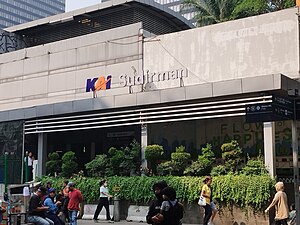
Sudirman Station (SUD, formerly Dukuh Atas Station) is a train station of KRL Commuterline, which is located in Menteng, Central Jakarta, Indonesia. The station is named from Jalan Jenderal Sudirman, one of the main avenue in Jakarta, which crosses above the station. This station is located on the north bank of West Flood Canal.

Karet railway station
Railway station in Indonesia
Distance: Approx. 558 meters
Latitude and longitude: -6.2008165,106.8159002
Karet Station (KAT) is a railway station located in Kebon Melati, Tanah Abang, Central Jakarta. This station lies on the north bank of West Flood Canal. This station only serves Commuterline trains.
Treasury Tower
Indonesian skyscraper
Distance: Approx. 416 meters
Latitude and longitude: -6.207163,106.821499
Treasury Tower is a 279.5-meter-tall skyscraper at District 8 complex in Sudirman Central Business District (SCBD) in South Jakarta. As of April 2024, it is the fifth -tallest building in Jakarta. The architectural height of the tower is 279.5 meters and the top floor is situated at 260.6 meters.

Astra Tower
Office in Jakarta, Indonesia
Distance: Approx. 415 meters
Latitude and longitude: -6.207162,106.821494
Astra Tower is a skyscraper located at Jalan Jenderal Sudirman in Jakarta, Indonesia. It is an office building with 63 floors and a private helipad. The podium of the tower has retail space and a food court, and a 1,000-person capacity conference hall.

Thamrin Nine
Mixed use in Jakarta, Indonesia
Distance: Approx. 589 meters
Latitude and longitude: -6.19914,106.82263
Thamrin Nine is a mixed-use development complex in Jakarta, Indonesia. It covers an area of approximately 570,000 square metres with office, retail, residential, hotels, sports and entertainment facilities. Its centrepiece, the Autograph Tower (382.9 m), is the tallest building in the Southern Hemisphere.
7Point8
Office in Jakarta, Indonesia
Distance: Approx. 537 meters
Latitude and longitude: -6.208379,106.821336
7Point8 is a skyscraper on-hold at Sudirman Avenue, Jakarta, Indonesia. The building is 298 meters tall and will have 60 floors above the ground and 5 floors below the ground. It is part of a complex of two towers, which will be linked by a multistory podium that will provide two tall exterior "walls" for the central plaza.

BNI City railway station
Railway station in Indonesia
Distance: Approx. 227 meters
Latitude and longitude: -6.201917,106.820913
BNI City station (Indonesian: Stasiun BNI City) is a station for the Soekarno-Hatta Airport Rail Link and KAI Commuter service. Bank Negara Indonesia (BNI) holds the naming rights for the station, which was known as Sudirman Baru station (English: New Sudirman station) during construction period. The station is located in Central Jakarta, on the north bank of West Flood Canal, about a hundred meters from Sudirman Commuter Rail station.

Dukuh Atas TOD
Transit-oriented development area in Jakarta, Indonesia
Distance: Approx. 227 meters
Latitude and longitude: -6.201917,106.820913
Dukuh Atas TOD (Indonesian: Kawasan Berorientasi Transit Dukuh Atas or KBT Dukuh Atas) is a transit-oriented development area between Central Jakarta and South Jakarta, Indonesia. This is built as part of constructing several other transit oriented development across Jakarta to facilitate commuters to transfer between different mode of public transportation. The development includes Dukuh Atas BNI station of Jakarta MRT, Sudirman station of KRL Commuterline, BNI City of Airport Rail Link, Dukuh Atas LRT station of Jabodebek LRT, and TransJakarta bus services.

Dukuh Atas BNI MRT station
MRT station in Jakarta, Indonesia
Distance: Approx. 448 meters
Latitude and longitude: -6.200786,106.822746
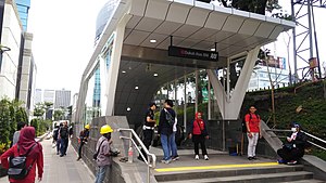
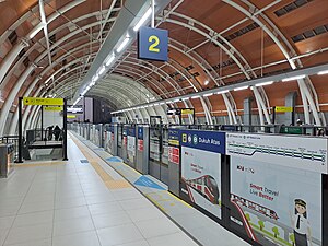
Dukuh Atas MRT Station (or Dukuh Atas BNI MRT Station, with BNI granted for naming rights) is a rapid transit station on the North-South Line of the Jakarta MRT. The station is located in the Kebon Melati area of Tanah Abang, Central Jakarta and is built under Jalan Jenderal Sudirman. As part of the Dukuh Atas TOD, the station is connected to many connecting transportation services, such as the Jabodetabek Commuter Line, Soekarno-Hatta International Airport Express Train, and Transjakarta. The station has only two railway lines separated by an island platform in the middle.

Setiabudi Astra MRT station
MRT station in Jakarta, Indonesia
Distance: Approx. 626 meters
Latitude and longitude: -6.2091,106.8217
Setiabudi MRT Station (or Setiabudi Astra MRT Station, with Astra International granted for naming rights) is a rapid transit station on the North-South Line of the Jakarta MRT. Located at Karet Kuningan, Setiabudi, South Jakarta. Despite the similar names, it is not an interchange and is not to be confused with the LRT Jabodebek station at Setiabudi LRT station, and is in fact located 600 meters apart from each other.

Dukuh Atas BNI LRT Station
LRT station in Indonesia
Distance: Approx. 634 meters
Latitude and longitude: -6.20470617,106.82564554
Dukuh Atas LRT Station (or Dukuh Atas BNI LRT Station, with Bank Negara Indonesia granted for naming rights) is a light rail station located within the Dukuh Atas TOD in Jalan Setia Budi Tengah, Kuningan Timur, Setiabudi, South Jakarta, Jakarta, Indonesia. The station, which is located at an altitude of +27.9 meters, serves the Cibubur and Bekasi lines of the Jabodebek LRT system.
Weather in this IP's area
light rain
26 Celsius
26 Celsius
26 Celsius
27 Celsius
1008 hPa
93 %
1008 hPa
1007 hPa
6000 meters
20 %
05:25:42
17:49:57