202.152.155.233 - IP Lookup: Free IP Address Lookup, Postal Code Lookup, IP Location Lookup, IP ASN, Public IP
Country:
 Indonesia
Region:
City:
Location:
Time Zone:
Postal Code:
ISP:
ASN:
language:
User-Agent:
Proxy IP:
Blacklist:
IP information under different IP Channel
ip-api
Country
Region
City
ASN
Time Zone
ISP
Blacklist
Proxy
Latitude
Longitude
Postal
Route
db-ip
Country
Region
City
ASN
Time Zone
ISP
Blacklist
Proxy
Latitude
Longitude
Postal
Route
IPinfo
Country
Region
City
ASN
Time Zone
ISP
Blacklist
Proxy
Latitude
Longitude
Postal
Route
IP2Location
202.152.155.233Country
idRegion
jawa tengah
City
slawi
Time Zone
Asia/Jakarta
ISP
Language
User-Agent
Latitude
Longitude
Postal
ipdata
Country
Region
City
ASN
Time Zone
ISP
Blacklist
Proxy
Latitude
Longitude
Postal
Route
Popular places and events near this IP address

Slawi
Distance: Approx. 837 meters
Latitude and longitude: -6.98333333,109.13333333
Slawi is the administrative centre of the Tegal Regency of the province of Central Java, Indonesia. Slawi is known for the production of a particularly fragrant black tea and the tea-drinking culture known as Moci.
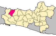
Tegal Regency
Regency of Indonesia
Distance: Approx. 4610 meters
Latitude and longitude: -6.96555556,109.17916667
Tegal Regency (Javanese:ꦏꦧꦸꦥꦠꦺꦤ꧀ꦠꦺꦒꦭ꧀) is one of the regencies in the northwest part of Central Java province of Indonesia, with an area of 970.95 km2 (374.89 sq mi). The administrative center used to be in Tegal City, in the northwest corner of the regency, but then Tegal City was administratively separated from the regency and formed into its own territory. The city was later replaced as the administrative center of Tegal Regency by Slawi Town, which is a suburb about 20 km (12 mi) to the south of the city and within the district boundary.

Jatibarang Lor
Village in Brebes Regency, Central Java, Indonesia
Distance: Approx. 9235 meters
Latitude and longitude: -6.96426111,109.05896667
Jatibarang Lor is a village (desa) in Jatibarang District of Brebes Regency, in Central Java Province of Indonesia.
Al-Ittihad Mosque Jatibarang
Mosque in Brebes, Central Java, Indonesia
Distance: Approx. 9720 meters
Latitude and longitude: -6.96444444,109.05444444
Al-Ittihad is the name of a mosque in Jatibarang Lor village of Jatibarang District in Brebes Regency, Indonesia.
Jatibarang, Brebes
District in Brebes Regency, Central Java Province, Indonesia
Distance: Approx. 8595 meters
Latitude and longitude: -6.96777778,109.06416667
Jatibarang District is an administrative district (Indonesian: Kecamatan) in Brebes Regency, Central Java, Indonesia. It covers 36.39 km2 (14.05 sq mi) and had a population of 82,868 at the 2010 Census and 87,185 at the 2020 Census.
Weather in this IP's area
scattered clouds
25 Celsius
25 Celsius
25 Celsius
25 Celsius
1010 hPa
86 %
1010 hPa
999 hPa
10000 meters
1.73 m/s
1.83 m/s
222 degree
36 %