Country:
Region:
City:
Latitude and Longitude:
Time Zone:
Postal Code:
IP information under different IP Channel
ip-api
Country
Region
City
ASN
Time Zone
ISP
Blacklist
Proxy
Latitude
Longitude
Postal
Route
Luminati
Country
Region
yo
City
yogyakarta
ASN
Time Zone
Asia/Jakarta
ISP
PT JEMBATAN CITRA NUSANTARA
Latitude
Longitude
Postal
IPinfo
Country
Region
City
ASN
Time Zone
ISP
Blacklist
Proxy
Latitude
Longitude
Postal
Route
db-ip
Country
Region
City
ASN
Time Zone
ISP
Blacklist
Proxy
Latitude
Longitude
Postal
Route
ipdata
Country
Region
City
ASN
Time Zone
ISP
Blacklist
Proxy
Latitude
Longitude
Postal
Route
Popular places and events near this IP address
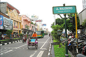
Jalan Malioboro
Major shopping street in Yogyakarta, Indonesia
Distance: Approx. 1136 meters
Latitude and longitude: -7.793359,110.365713
Jalan Malioboro (Javanese: ꦢꦭꦤ꧀ꦩꦭꦶꦪꦧꦫ, romanized: Dalan Maliyabara; English: Malioboro Street) is a major shopping street in Yogyakarta, Indonesia; the name is also used more generally for the neighborhood around the street. It lies north–south axis in the line between Yogyakarta Kraton and Mount Merapi. This is in itself is significant to many of the local population, the north–south orientation between the palace and the volcano being of importance.

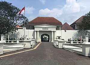
Fort Vredeburg Museum
History museum in Jalan Ahmad Yani No. 6, Yogyakarta
Distance: Approx. 399 meters
Latitude and longitude: -7.800375,110.366378
Fort Vredeburg Museum (Indonesian: Museum Benteng Vredeburg; Javanese: ꦩꦸꦱꦶꦪꦸꦩ꧀ꦧꦺꦠꦺꦁꦮ꦳ꦽꦢꦼꦧꦸꦂꦒ꧀, romanized: Musiyum Bètèng Vredeburg) was a former colonial fortress located in the city of Yogyakarta, Special Region of Yogyakarta, Indonesia. The military complex—owned by the Yogyakarta Sultanate, but leased to the central government and managed by an agency of the central government—has been converted into a museum of the Indonesian independence struggle which was opened in 1992. It is located in front of Gedung Agung and near the Kraton Yogyakarta (Sultan's Palace).

Yogyakarta
Capital of the Special Region of Yogyakarta, Indonesia
Distance: Approx. 236 meters
Latitude and longitude: -7.80138889,110.36444444
Yogyakarta (English: YOHG-yə-KAR-tə; Javanese: ꦔꦪꦺꦴꦒꦾꦏꦂꦠ Ngayogyakarta [ŋɑːˈjɔɡjɔˈkɑːrtɔ]; Petjo: Jogjakarta) is the capital city of the Special Region of Yogyakarta in Indonesia, in the south-central part of the island of Java. As the only Indonesian royal city still ruled by a monarchy, Yogyakarta is regarded as an important centre for classical Javanese fine arts and culture such as ballet, batik textiles, drama, literature, music, poetry, silversmithing, visual arts, and wayang puppetry. Renowned as a centre of Indonesian education, Yogyakarta is home to a large student population and dozens of schools and universities, including Gadjah Mada University, the country's largest institute of higher education and one of its most prestigious.

Kraton Ngayogyakarta Hadiningrat
Royal palace complex in Yogyakarta, Indonesia
Distance: Approx. 251 meters
Latitude and longitude: -7.805689,110.36406
The Royal Palace of Yogyakarta (Indonesian: Keraton Ngayogyakarta Hadiningrat, Javanese: ꦏꦿꦠꦺꦴꦤ꧀ꦔꦪꦺꦴꦒꦾꦏꦂꦠꦲꦢꦶꦤꦶꦔꦿꦠ꧀, romanized: Kadhaton Ngayogyakarta Adiningrat) is a palace complex in the city of Yogyakarta, Yogyakarta Special Region, Indonesia. It is the seat of the reigning Sultan of Yogyakarta and his family. The complex is a center of Javanese culture and contains a museum displaying royal artifacts.

Sonobudoyo Museum
Museum in Yogyakarta, Indonesia
Distance: Approx. 202 meters
Latitude and longitude: -7.801785,110.364003
The Sonobudoyo Museum (Javanese: ꦩꦸꦱꦶꦪꦸꦩ꧀ꦱꦤꦧꦸꦢꦪ, romanized: Musiyum Sanabudaya) is a Javanese history and culture museum and library in Yogyakarta, Indonesia. The museum contains the most complete collection of Javanese artifacts, after the National Museum in Jakarta. In addition to ceramics of the Neolithic era and bronze sculptures from the 8th century, the museum also includes collections of wayang (shadow puppets), various ancient weapons (such as keris), and Javanese masks.

Taman Sari (Yogyakarta)
Former royal garden in Yogakarta, Indonesia
Distance: Approx. 968 meters
Latitude and longitude: -7.810151,110.358946
Taman Sari Water Castle, also known as Taman Sari (Javanese: ꦠꦩꦤ꧀ ꦱꦫꦶ), is the site of a former royal garden of the Sultanate of Yogyakarta. It is located about 2 km south within the grounds of the Kraton, Yogyakarta, Indonesia. Built in the mid-18th century, the Taman Sari had multiple functions, such as a resting area, a workshop, a meditation area, a defense area, and a hiding place.

Taman Pintar Yogyakarta
Science museum in Yogyakarta, Indonesia
Distance: Approx. 458 meters
Latitude and longitude: -7.80055556,110.3675
Taman Pintar Yogyakarta (lit. 'Yogyakarta Smart Park'), or just Taman Pintar, is a science-themed park and museum for kids and a place for expression, appreciation, creation in a pleasant situation. It is situated on the center of the city of Yogyakarta, on Jalan Panembahan Senopati. Bringing its motto educate and pleasant, the place that was firstly built in 2004 wants to increase the intention of kids and the young generation in science through imaginations, trials, and games in order to improve the human resources.
Jogja National Museum
Modern art museum in Yogyakarta, Indonesia
Distance: Approx. 1287 meters
Latitude and longitude: -7.80015613,110.35343268
Jogja National Museum (JNM) is a contemporary art museum in Yogyakarta, Indonesia. JNM has established under Yayasan Yogyakarta Seni Nusantara (YYSN) management, JNM building complex was first a Former First Indonesia Visual Art School (ASRI-1950) and Faculty of Visual Art and Design (FSRD-1984) which later became Indonesian Institute of the Arts, Yogyakarta.
Bintaran
Distance: Approx. 1345 meters
Latitude and longitude: -7.805,110.3767
Bintaran (Javanese: ꦧꦶꦤ꧀ꦠꦫꦤ꧀) is a village in Wirogunan, Mergangsan, Yogyakarta, Indonesia. The area is known for its Dutch-Javanese architecture. It was formerly a Catholic settlement.

Gedung Agung
Building in Gondomanan, Yogyakarta
Distance: Approx. 364 meters
Latitude and longitude: -7.80022736,110.36454017
The Gedung Agung (English: The Great Building; Javanese: ꦒꦼꦝꦺꦴꦁꦄꦒꦼꦁ, romanized: Gedhong Ageng) is one of seven presidential palaces of Indonesia, it is located in the city of Yogyakarta. The palace complex covers an area of approximately 4.4 hectares. It is located in front of Fort Vredeburg.

Kauman Great Mosque
Mosque in Yogyakarta, Indonesia
Distance: Approx. 231 meters
Latitude and longitude: -7.80394615,110.36255535
Kauman Great Mosque, approximate English translation of Javanese Mesjid Gedhe Kauman (Javanese: ꦩꦱ꧀ꦗꦶꦢ꧀ꦒꦼꦝꦺꦏꦲꦸꦩ꧀ꦩꦤ꧀; officially Mesjid Gedhe Kauman Karaton Ngayogyakarta Hadiningrat), is a Great Mosque of the Yogyakarta Sultanate in Java, Indonesia. It is located to the west of the North Alun-alun (public square) of Yogyakarta Kraton.

Yogyakarta metropolitan area
Metropolitan area in Special Region of Yogyakarta, Indonesia
Distance: Approx. 236 meters
Latitude and longitude: -7.80138889,110.36444444
The Greater Yogyakarta, known locally as Kartamantul (Javanese: ꦏꦂꦠꦩꦤ꧀ꦠꦸꦭ꧀, romanized: Kartamantul), an acronym of Yogyakarta–Sleman–Bantul, is a built-up area in Special Region of Yogyakarta, Indonesia. Although unofficial, the Greater Yogyakarta sometimes referred to as the Yogyakarta metropolitan area.
Weather in this IP's area
overcast clouds
25 Celsius
26 Celsius
25 Celsius
25 Celsius
1008 hPa
88 %
1008 hPa
996 hPa
10000 meters
1.53 m/s
1.67 m/s
40 degree
100 %
05:09:11
17:36:39

