Country:
 Pakistan
Region:
City:
Latitude and Longitude:
Time Zone:
Postal Code:
IP information under different IP Channel
ip-api
Country
Region
City
ASN
Time Zone
ISP
Blacklist
Proxy
Latitude
Longitude
Postal
Route
IPinfo
Country
Region
City
ASN
Time Zone
ISP
Blacklist
Proxy
Latitude
Longitude
Postal
Route
MaxMind
Country
Region
City
ASN
Time Zone
ISP
Blacklist
Proxy
Latitude
Longitude
Postal
Route
Luminati
Country
PKRegion
kp
City
peshawar
ASN
Time Zone
Asia/Karachi
ISP
Multinet Broadband
Latitude
Longitude
Postal
db-ip
Country
Region
City
ASN
Time Zone
ISP
Blacklist
Proxy
Latitude
Longitude
Postal
Route
ipdata
Country
Region
City
ASN
Time Zone
ISP
Blacklist
Proxy
Latitude
Longitude
Postal
Route
Popular places and events near this IP address
Qayyum Stadium
Sports venue in Peshawar, Pakistan
Distance: Approx. 1614 meters
Latitude and longitude: 33.99322222,71.53538889
The Qayyum Stadium, also known as Peshawar Sport Complex, is located in Peshawar, the capital of Khyber Pakhtunkhwa province in Pakistan. It is the biggest sports complex not just in Peshawar but in all of Khyber Pakhtunkhwa. The sport complex has facilities for all major sports including football, field hockey, squash, wrestling and badminton.
Kotla Mohsin Khan
Union Council in Khyber Pakhtunkhwa, Pakistan
Distance: Approx. 1154 meters
Latitude and longitude: 33.987,71.551
Kotla Mohsin Khan (Pashto: کوټلا محسن خان, Hindko; Urdu: کوٹلا محسن خان) is a historic gate located on Kohat Road in Peshawar, Khyber Pakhtunkhwa Pakistan, and also serves as a neighbourhood.
Burj-e-Roshnai
Distance: Approx. 1659 meters
Latitude and longitude: 33.9919,71.5525
Burj-e-Roshnai is located in Peshawar, Khyber Pakhtunkhwa province, Pakistan. There are two historical tombs located in Kotla Mohsin Khan, Peshawar, they are called Burj-e-Roshnai. They are one of the great architectural signs of the Mughal dynasty.
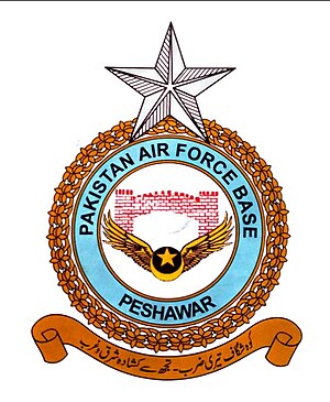
PAF Base Peshawar
Pakistan Air Force military installation
Distance: Approx. 2026 meters
Latitude and longitude: 33.9944,71.5289
Pakistan Air Force Base, Peshawar is an airbase of the Pakistan Air Force (PAF) located in Peshawar, Khyber Pakhtunkhwa, Pakistan. It is the operational site of the PAF's Northern Air Command, located to the east of Bacha Khan International Airport, which is shared by both civil aviation flights and military flights.

Peshawar Cantonment railway station
Railway station in Pakistan
Distance: Approx. 2614 meters
Latitude and longitude: 34.0023,71.5501
Peshawar Cantonment Railway Station (Urdu: پشاور چھاؤنی ریلوے اسٹیشن, Pashto: د پېښور اردوگاه اورګاډي سټيشن) (often abbreviated as Peshawar Cantt) is the principal railway station in Peshawar, in the Khyber Pakhtunkhwa province of Pakistan. It is located on Saddar Road. The station is staffed and has a booking office.
Landi Arbab
Village in Peshawar District, Pakistan
Distance: Approx. 254 meters
Latitude and longitude: 33.97944444,71.54472222
Landi Arbab (Pashto: () (formerly Sultan Pura: سلطان پورہ) is a village in Peshawar, Pakistan. The village is a 15-minute drive away from Peshawar International Airport and Peshawar Saddar. The village is largely populated by the Qazi, Arbab, Murad Khel, Malaks, Syed, Ahmad Zai, Fateh Khan Khel, Qasab and Ghorghust clans.
Sarhad University of Science & Information Technology
Private university in Pakistan
Distance: Approx. 2156 meters
Latitude and longitude: 33.9636,71.5292
The Sarhad University of Science and Information Technology (colloquially known as Sarhad University) is a private university in Peshawar, Khyber-Pakhtunkhwa, Pakistan. Established in 2001, it offers a wide range of programs from bachelor to doctoral level. It is the only private university in Pakistan to have recently introduced an educational satellite channel SUIT TV. The aim is to facilitate convenient access to education for students in the current era.
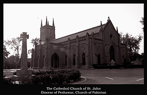
St. John's Church, Peshawar
Church in Peshawar, Pakistan
Distance: Approx. 2354 meters
Latitude and longitude: 33.9988,71.5308
St. John's Church, Peshawar, Pakistan, is the oldest in that city, constructed between 1851 and 1860. It is now called the Cathedral Church of St John, which is located in the cantonment next to the Peshawar Club.

Peshawar Cantonment
Cantonment in Khyber Pakhtunkhwa, Pakistan
Distance: Approx. 2357 meters
Latitude and longitude: 34.00055556,71.53694444
Peshawar Cantonment (Urdu: پشاور چھاؤنی, Pashto: د پیښور کنډک) is a garrison located in Peshawar, Khyber Pakhtunkhwa, Pakistan. Although the cantonment is located within Peshawar City District, it is an independent municipality under control of the Military Lands and Cantonments Department of the Ministry of Defence. Popular areas in the Cantonment are Garrison Rangers Club, Army Stadium Park, Peshawar Services Club, Serena Hotel, Food court, PAF Hospital and others.
2012 Bacha Khan International Airport attack
Tehrik-i-Taliban attack in Peshawar, Pakistan
Distance: Approx. 2966 meters
Latitude and longitude: 33.99388889,71.51472222
The 2012 Bacha Khan International Airport attack was a coordinated assault on Bacha Khan International Airport and the adjacent Pakistan Air Force Base Peshawar on 22 December 2012 by Tehrik-i-Taliban terrorists in Peshawar, Khyber Pakhtunkhwa, Pakistan.

Kalibari Mandir, Peshawar
Hindu temple in Peshawar, Pakistan
Distance: Approx. 2088 meters
Latitude and longitude: 33.99855556,71.54166667
Kalibari Mandir (Sanskrit: कालीबरी मंदिर) is a Hindu temple in Peshawar, in the Khyber Pakhtunkhwa province of Pakistan. This temple is dedicated to the Hindu goddess Kali and Durga Puja is its main festival.
Sunehri Mosque, Peshawar
Mosque in Peshawar, Khyber Pakhtunkhwa, Pakistan
Distance: Approx. 1812 meters
Latitude and longitude: 33.996,71.5401
Sunehri Mosque (Urdu: سنہری مسجد) is a mosque located in located in Peshawar, Pakistan. It is known for its considerable size and Mughal-style architecture.
Weather in this IP's area
haze
22 Celsius
22 Celsius
22 Celsius
22 Celsius
1012 hPa
60 %
1012 hPa
971 hPa
5000 meters
3.09 m/s
230 degree
20 %
06:12:35
17:50:24