Country:
 India
IndiaRegion:
City:
Latitude and Longitude:
Time Zone:
Postal Code:
IP information under different IP Channel
ip-api
Country
Region
City
ASN
Time Zone
ISP
Blacklist
Proxy
Latitude
Longitude
Postal
Route
IPinfo
Country
Region
City
ASN
Time Zone
ISP
Blacklist
Proxy
Latitude
Longitude
Postal
Route
MaxMind
Country
Region
City
ASN
Time Zone
ISP
Blacklist
Proxy
Latitude
Longitude
Postal
Route
Luminati
Country
INRegion
wb
City
kolkata
ASN
Time Zone
Asia/Kolkata
ISP
INDINET SERVICE PRIVATE LIMITED
Latitude
Longitude
Postal
db-ip
Country
Region
City
ASN
Time Zone
ISP
Blacklist
Proxy
Latitude
Longitude
Postal
Route
ipdata
Country
Region
City
ASN
Time Zone
ISP
Blacklist
Proxy
Latitude
Longitude
Postal
Route
Popular places and events near this IP address

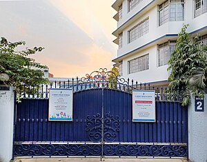
South Point School
Private school in Kolkata, West Bengal
Distance: Approx. 1101 meters
Latitude and longitude: 22.52583333,88.37666667
South Point is a higher-secondary co-educational private school located in Kolkata, West Bengal and affiliated to Central Board of Secondary Education, consisting of three organisations – South Point School (Nursery to Class V), South Point High School (Classes VI to XII) and South Point Education Society (administrative authority). The school operates in two shifts for all classes – Morning and Afternoon. The school opened in 1954, and was the first co-educational school in Kolkata.
Garden High School
Private school in Kolkata, West Bengal, India
Distance: Approx. 875 meters
Latitude and longitude: 22.5195414,88.3915427
Garden High School is a private, English-medium, co-educational school in Kasba, Kolkata, West Bengal, India. It was established in 2000 by the Satikanta Guha Foundation. It is affiliated to the Council for the Indian School Certificate Examinations (CISCE), New Delhi, for the ICSE (Class X) and ISC (Class XII) examinations.

Kasba, Kolkata
Neighbourhood in Kolkata in West Bengal, India
Distance: Approx. 94 meters
Latitude and longitude: 22.5176,88.384
Kasba is an upscale and standard locality of South Kolkata, in Kolkata district, West Bengal, India. It is situated in the southern part of the city encircled by the Sealdah South section of the Eastern Railways to the west, Dhakuria and Haltu to the south, the Eastern Metropolitan Bypass to the east and the locality of Tiljala to the north.

Naba Ballygunge Mahavidyalaya
Undergraduate college under Calcutta University
Distance: Approx. 213 meters
Latitude and longitude: 22.5199,88.383
Naba Ballygunge Mahavidyalaya, formerly known as Charu Chandra Evening College, established in 1985, is an undergraduate college in Kasba, West Bengal, India. It is affiliated with the University of Calcutta.

Tiljala
Neighbourhood in East Kolkata, West Bengal, India
Distance: Approx. 1124 meters
Latitude and longitude: 22.527861,88.385564
Tiljala is a neighbourhood of East Kolkata, in West Bengal, India.
Ward No. 67, Kolkata Municipal Corporation
Kolkata Municipal Corporation in West Bengal, India
Distance: Approx. 955 meters
Latitude and longitude: 22.523889,88.376444
Ward No. 67, Kolkata Municipal Corporation is an administrative division of Kolkata Municipal Corporation in Borough No. 7, covering parts of Tiljala (Kata Pukur-Bediadanga) and Kasba (Natore Park-New Ballygunge-Bosepukur) neighbourhoods in South Kolkata, in the Indian state of West Bengal.
Ward No. 91, Kolkata Municipal Corporation
Kolkata Municipal Corporation in West Bengal, India
Distance: Approx. 504 meters
Latitude and longitude: 22.516222,88.378694
Ward No. 91, Kolkata Municipal Corporation is an administrative division of Kolkata Municipal Corporation in Borough No. 10, covering parts of Kasba (Rathtala-Bosepukur) and Dhakuria (Kalupara-Kamala Park) neighbourhoods in South Kolkata, in the Indian state of West Bengal.
Ward No. 105, Kolkata Municipal Corporation
Kolkata Municipal Corporation in West Bengal, India
Distance: Approx. 1326 meters
Latitude and longitude: 22.506833,88.387694
Ward No. 105, Kolkata Municipal Corporation is an administrative division of Kolkata Municipal Corporation in Borough No. 12, covering parts of Haltu (Baidya Para-Jadavgarh-Ashutosh Colony-Sarat Bose Colony-Nazir Bagan-Sucheta Nagar-Neli Nagar) and Garfa (Manasatala) neighbourhoods in South Kolkata, in the Indian state of West Bengal.
Ward No. 106, Kolkata Municipal Corporation
Kolkata Municipal Corporation in West Bengal, India
Distance: Approx. 1120 meters
Latitude and longitude: 22.508833,88.387694
Ward No. 106, Kolkata Municipal Corporation is an administrative division of Kolkata Municipal Corporation in Borough No. 12, covering parts of Haltu (Nandi Bagan-Kayasthapara-Ramlal Bazar-Shanti Pally-Purbachal-North Purbachal-Unique Park-Safuipara-Sukhpally-Gitanjali Park-Kalitala-Kalikapur) neighbourhood in South Kolkata, in the Indian state of West Bengal.
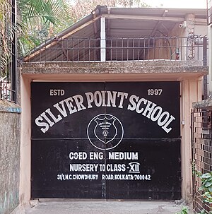
Silver Point School
English medium school in Kolkata, West Bengal, India
Distance: Approx. 773 meters
Latitude and longitude: 22.5135253,88.3774555
Silver Point School is an English-medium co-ed school located at 31/1, N.C Chowdhury road, Kolkata – 700042 (Junior) and located at 198/1,Kasba road Kolkata-700042 ( Senior).

Ballygunge Junction railway station
Railway Station in West Bengal, India
Distance: Approx. 1139 meters
Latitude and longitude: 22.5191616,88.3721923
Ballygunge Junction railway station is a Kolkata Suburban Railway junction station on the Main line with an approximate 6 kilometres (3.7 mi) distance from the Sealdah railway station. It is under the jurisdiction of the Eastern Railway zone of Indian Railways. Ballygunge Junction railway station is one of the busiest railway stations in the Sealdah railway division.
Nandi Bagan
Neighbourhood in Kolkata in West Bengal, India
Distance: Approx. 988 meters
Latitude and longitude: 22.509346,88.3853145
Nandy Bagan or Nandi Bagan is a neighbourhood of South Kolkata in the Indian state of West Bengal. It is a residential area surrounded with Kasba, Haltu, Garfa, Jadavpur, Babu Bagan, Dhakuria, Naskarpara, Shahid Nagar, Bosepukur and Selimpur. It is traditionally an upper-middle-class neighbourhood, situated around the Nandi Bagan community playground.
Weather in this IP's area
haze
28 Celsius
34 Celsius
28 Celsius
28 Celsius
1003 hPa
94 %
1003 hPa
1002 hPa
3500 meters
3.6 m/s
120 degree
75 %
05:23:49
17:38:16