Country:
Region:
City:
Latitude and Longitude:
Time Zone:
Postal Code:
IP information under different IP Channel
ip-api
Country
Region
City
ASN
Time Zone
ISP
Blacklist
Proxy
Latitude
Longitude
Postal
Route
Luminati
Country
ASN
Time Zone
Asia/Kolkata
ISP
Seven Star Digital Network Private Limited
Latitude
Longitude
Postal
IPinfo
Country
Region
City
ASN
Time Zone
ISP
Blacklist
Proxy
Latitude
Longitude
Postal
Route
db-ip
Country
Region
City
ASN
Time Zone
ISP
Blacklist
Proxy
Latitude
Longitude
Postal
Route
ipdata
Country
Region
City
ASN
Time Zone
ISP
Blacklist
Proxy
Latitude
Longitude
Postal
Route
Popular places and events near this IP address

Marathwada
Segmented region of the Kingdom of Hyderabad
Distance: Approx. 6715 meters
Latitude and longitude: 19.8833,75.3333
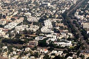
Marathwada (Marathi pronunciation: [məɾaːʈʰʋaːɖa]) is a proposed state and geographical region of the Indian state of Maharashtra. It was formed during the Nizam's rule and was part of the then Hyderabad State. The region coincides with the Aurangabad division of Maharashtra.
Aurangabad district, Maharashtra
District of Maharashtra in India
Distance: Approx. 6032 meters
Latitude and longitude: 19.88878611,75.34343611
Aurangabad district (Marathi pronunciation: [əu̯ɾəŋɡaːbaːd̪]), officially known as Chhatrapati Sambhaji Nagar district, is one of the 36 districts of the state of Maharashtra in western India. It borders the districts of Nashik to the west, Jalgaon to the north, Jalna to the east, and Ahmednagar to the south. The city of Aurangabad houses the district's administrative headquarters.

Aurangabad division
Place in Maharashtra, India
Distance: Approx. 6032 meters
Latitude and longitude: 19.88878611,75.34343611
Aurangabad division, officially known as Chhatrapati Sambhajinagar division is one of the six administrative divisions of Maharashtra state in India. It represents the Marathwada region of Maharashtra and is synonymous with it.

Aurangabad Airport
Airport in Aurangabad, Maharashtra, India
Distance: Approx. 575 meters
Latitude and longitude: 19.86277778,75.39805556
Aurangabad Airport (IATA: IXU, ICAO: VAAU) is a domestic airport and a seasonal international airport serving the city of Aurangabad, Maharashtra, India. It is located at Chikalthana, about 5.5 km east of the city centre and 11 km from Aurangabad Railway Station, along the Aurangabad–Nagpur State Highway. The airport is owned and operated by the Airports Authority of India, with one passenger terminal with 190,000 square feet of floor area and two aerobridges.

Indian Airlines Flight 491
1993 aviation accident
Distance: Approx. 5033 meters
Latitude and longitude: 19.875,75.43861111
Indian Airlines Flight 491 (IC491/IAC491) was a scheduled domestic passenger flight from Aurangabad to Bombay, operated by India's national airline Indian Airlines. On 26 April 1993, the aircraft operating the flight, a Boeing 737-2A8 with a registration of VT-ECQ crashed shortly after take-off following the aircraft's impact with a lorry and a high tension power line. The crash killed 55 people and injured 63 others.

Jawaharlal Nehru Engineering College
Engineering college im Maharashtra, India
Distance: Approx. 4437 meters
Latitude and longitude: 19.8806,75.356
The Jawaharlal Nehru Engineering College (JNEC) is an engineering college in Aurangabad CIDCO, India. It was established in 1982 and is affiliated with the Dr. Babasaheb Ambedkar Technological University in Maharashtra.

Aurangabad, Maharashtra Lok Sabha constituency
Lok Sabha Constituency in Maharashtra
Distance: Approx. 6032 meters
Latitude and longitude: 19.88878611,75.34343611
Aurangabad Lok Sabha constituency is one of the 48 Lok Sabha (parliamentary) constituencies in Maharashtra state in western India.
Gates in Aurangabad
Distance: Approx. 6032 meters
Latitude and longitude: 19.88878611,75.34343611
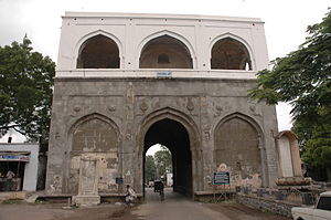
The Gates of Aurangabad distinguish it from several other medieval cities in India. Each of the 52 gates have a local history or had individuals linked with it. Out of the 52, only four main and nine subordinate gates have survived, the most famous, oldest and biggest of them being the Bhadkal Gate near the Naukhanda Palace of Nizams.

Aurangabad CIDCO
Planned city in India
Distance: Approx. 3114 meters
Latitude and longitude: 19.87405556,75.36659722
Aurangabad CIDCO (औरंगाबाद सिडको) is a planned city in Maharashtra state, India. Indian politician Rafiq Zakaria contested the first election of the newly created Maharashtra state in 1962, from Aurangabad and was elected to Maharashtra assembly. He was made Minister for Urban Development in the new ministry.

Prozone Mall Aurangabad
Shopping mall in Maharashtra, India
Distance: Approx. 2742 meters
Latitude and longitude: 19.87611111,75.37222222
Prozone Mall is one of the largest, as well as one of the first horizontally designed shopping malls in India. It has over 600,000 sq ft (56,000 m2) of retail space and was the first modern mall in Aurangabad.

Aurangabad East Assembly constituency
Constituency of the Maharashtra legislative assembly in India
Distance: Approx. 6661 meters
Latitude and longitude: 19.87,75.33
Aurangabad East Assembly constituency is one of the six constituencies of Maharashtra Vidhan Sabha located in Aurangabad district, Maharashtra.

Qila-e-Ark
Palace fort in Aurangabad, Maharashtra
Distance: Approx. 6032 meters
Latitude and longitude: 19.88878611,75.34343611
Qila-e-Ark is a 17th-century palace/citadel complex in Aurangabad, Maharashtra. Built by Mughal emperor Aurangzeb when he was a prince, it served as his royal residence during his subsequent reign as emperor. The site is currently ruined, and has no legal protected status; several modern-day buildings also encroach the complex.
Weather in this IP's area
overcast clouds
20 Celsius
19 Celsius
20 Celsius
20 Celsius
1013 hPa
62 %
1013 hPa
947 hPa
10000 meters
2.04 m/s
2.08 m/s
86 degree
99 %
06:37:14
17:49:05

