202.126.24.15 - IP Lookup: Free IP Address Lookup, Postal Code Lookup, IP Location Lookup, IP ASN, Public IP
Country:
 Japan
JapanRegion:
City:
Location:
Time Zone:
Postal Code:
ISP:
ASN:
language:
User-Agent:
Proxy IP:
Blacklist:
IP information under different IP Channel
ip-api
Country
Region
City
ASN
Time Zone
ISP
Blacklist
Proxy
Latitude
Longitude
Postal
Route
db-ip
Country
Region
City
ASN
Time Zone
ISP
Blacklist
Proxy
Latitude
Longitude
Postal
Route
IPinfo
Country
Region
City
ASN
Time Zone
ISP
Blacklist
Proxy
Latitude
Longitude
Postal
Route
IP2Location
202.126.24.15Country
jpRegion
yamaguchi
City
shimonoseki
Time Zone
Asia/Tokyo
ISP
Language
User-Agent
Latitude
Longitude
Postal
ipdata
Country
Region
City
ASN
Time Zone
ISP
Blacklist
Proxy
Latitude
Longitude
Postal
Route
Popular places and events near this IP address

Kanmon Straits
Stretch of water separating Honshu and Kyushu in Japan
Distance: Approx. 1307 meters
Latitude and longitude: 33.94694444,130.94666667
The Kanmon Straits (関門海峡, Kanmon-kaikyō) or the Straits of Shimonoseki is the stretch of water separating Honshu and Kyushu, two of Japan's four main islands. On the Honshu side of the strait is Shimonoseki (下関, which contributed "Kan" (関) to the name of the strait) and on the Kyushu side is Kitakyushu, whose former city and present ward, Moji (門司), gave the strait its "mon" (門). The straits silt up at the rate of about 15 centimetres per annum, and dredging has made it possible to build the Kitakyushu Airport at low cost.

Shimonoseki
City in Yamaguchi Prefecture, Japan
Distance: Approx. 1162 meters
Latitude and longitude: 33.95777778,130.94138889
Shimonoseki (Japanese: 下関市, Hepburn: Shimonoseki-shi) is a city located in Yamaguchi Prefecture, Japan. As of 30 June 2023, the city had an estimated population of 248,193 in 128,762 households and a population density of 350 persons per km2. The total area of the city is 716.18 square kilometres (276.52 sq mi).
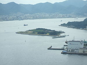
Ganryū-jima
Island in Japan between Honshū and Kyūshū
Distance: Approx. 1872 meters
Latitude and longitude: 33.93333333,130.93027778
Ganryū-jima (巌流島, formerly Funa-jima 船島) is an island in Japan located between Honshū and Kyūshū, and accessible via ferry from Shimonoseki Harbor (下関港).

Shimonoseki Junior College
College in Japan
Distance: Approx. 1667 meters
Latitude and longitude: 33.9625,130.92305556
Shimonoseki Junior College (下関短期大学, Shimonoseki tanki daigaku) is a private junior college in Shimonoseki, Yamaguchi, Japan. The school opened in 1962 as a women's junior college with enrollment of 32 students. In 2001 it became coeducational, adopting the present name at the same time.

Shimonoseki Station
Railway station in Shimonoseki, Yamaguchi Prefecture, Japan
Distance: Approx. 917 meters
Latitude and longitude: 33.95040556,130.92308333
Shimonoseki Station (下関駅, Shimonoseki-eki) is a passenger railway station located in the city of Shimonoseki, Yamaguchi Prefecture, Japan. It is operated by the West Japan Railway Company (JR West). The station is a freight depot of the Japan Freight Railway Company (JR Freight).

Akama Shrine
Shinto shrine in Yamaguchi Prefecture, Japan
Distance: Approx. 1792 meters
Latitude and longitude: 33.95972222,130.94847222
Akama Shrine (赤間神宮, Akama Jingū) is a Shinto shrine in Shimonoseki, Yamaguchi Prefecture, Japan. It is dedicated to the child Emperor Antoku, who died in the Battle of Dan-no-ura (aka Dannoura), which occurred nearby in 1185. This battle was important in the history of Japan because it brought an end to Genpei War in which the Minamoto clan defeated the rival Taira clan, and ended the Taira bid for control of Japan.

Kaikyo Messe Shimonoseki
Distance: Approx. 326 meters
Latitude and longitude: 33.950109,130.929468
Yamaguchi International Trade & Cultural Center or Kaikyo Messe Shimonoseki (海峡メッセ下関) is a complex facility located in Shimonoseki, Yamaguchi Prefecture, Japan. This building consists of Kaikyō Yume Tower and the International Trade Building.

Buzenda
Commercial area in Shimonoseki, Japan
Distance: Approx. 573 meters
Latitude and longitude: 33.95176944,130.92717222
Buzenda (豊前田, ぶぜんだ) refers to the downtown area of Shimonoseki City, Japan. It is located in the Shimonoseki Station area, and it is known as the most famous downtown area in Yamaguchi Prefecture. There are izakaya, karaoke bars, and other social venues around Buzenda-cho-2.

Karato
Area in Shimonoseki, Yamaguchi, Japan
Distance: Approx. 1143 meters
Latitude and longitude: 33.95666667,130.94241667
Karato (唐戸) is the downtown area of the city of Shimonoseki, Japan. It is known as the most famous sightseeing spot in Yamaguchi Prefecture.

Shimonoseki Station massacre
Mass stabbing and car ramming attack in Shimonoseki, Japan
Distance: Approx. 1022 meters
Latitude and longitude: 33.949,130.922
The Shimonoseki Station massacre (Japanese: 下関通り魔殺人事件, romanized: Shimonoseki tōrima satsujin jiken) was a mass murder that occurred in Shimonoseki, Japan on 29 September 1999. Yasuaki Uwabe, a 35-year-old former architect, drove a car into Shimonoseki Station and then stabbed passers-by at random, killing five people and injuring 10 others, before being arrested at the scene. Uwabe was sentenced to death in 2002 and executed in 2012.

Saving Athletic Stadium
Distance: Approx. 1815 meters
Latitude and longitude: 33.9663,130.9333
Shimonoseki Stadium (下関市営下関陸上競技場) is an athletic stadium in Shimonoseki, Yamaguchi Prefecture, Japan. It is the home stadium of football clubs Renofa Yamaguchi FC and FC Baleine Shimonoseki.

Kameyama Hachimangū
Shinto shrine located in Shimonoseki, Yamaguchi Prefecture, Japan
Distance: Approx. 1387 meters
Latitude and longitude: 33.9575,130.945
Kameyama Hachimangū (亀山八幡宮, Kameyama Hachimangū) is a Shinto shrine located in Shimonoseki, Yamaguchi Prefecture, Japan. It is a Hachiman shrine, dedicated to the kami Hachiman. The kami enshrined there include Emperor Ōjin, Empress Jingū, and Emperor Chūai.
Weather in this IP's area
broken clouds
6 Celsius
3 Celsius
6 Celsius
6 Celsius
1024 hPa
45 %
1024 hPa
1019 hPa
10000 meters
4.12 m/s
300 degree
75 %