Country:
 New Zealand
Region:
City:
Latitude and Longitude:
Time Zone:
Postal Code:
IP information under different IP Channel
ip-api
Country
Region
City
ASN
Time Zone
ISP
Blacklist
Proxy
Latitude
Longitude
Postal
Route
IPinfo
Country
Region
City
ASN
Time Zone
ISP
Blacklist
Proxy
Latitude
Longitude
Postal
Route
MaxMind
Country
Region
City
ASN
Time Zone
ISP
Blacklist
Proxy
Latitude
Longitude
Postal
Route
Luminati
Country
NZASN
Time Zone
Pacific/Auckland
ISP
Vector Communications LTD.
Latitude
Longitude
Postal
db-ip
Country
Region
City
ASN
Time Zone
ISP
Blacklist
Proxy
Latitude
Longitude
Postal
Route
ipdata
Country
Region
City
ASN
Time Zone
ISP
Blacklist
Proxy
Latitude
Longitude
Postal
Route
Popular places and events near this IP address

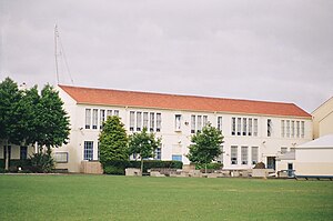
Auckland Grammar School
New Zealand state run secondary school for boys
Distance: Approx. 625 meters
Latitude and longitude: -36.86916667,174.76944444
Auckland Grammar School (often simplified to Auckland Grammar, or Grammar), established in 1869, is a state, day and boarding secondary school for boys in Auckland, New Zealand. The school was originally situated on Howe Street in Freeman’s Bay, where Auckland Girls Grammar School is now located. It moved to its current site on Mountain Road in Epsom in 1916.

University of Auckland Faculty of Medical and Health Sciences
Distance: Approx. 516 meters
Latitude and longitude: -36.8618,174.7697
The University of Auckland Faculty of Medical and Health Sciences (FMHS; Māori: Mātauranga Hauora) was established in 1968 as The University of Auckland School of Medicine at its present site in Grafton, Auckland. Prior to this, the University of Otago had taught some students from the final years of its medical course in Auckland through a branch faculty of the Dunedin School of Medicine.

Auckland War Memorial Museum
Museum and war memorial in Auckland, New Zealand
Distance: Approx. 615 meters
Latitude and longitude: -36.86027778,174.77777778
The Auckland War Memorial Museum (Māori: Tāmaki Paenga Hira), also known as Auckland Museum, is one of New Zealand's most important museums and war memorials. Its neoclassical building constructed in the 1920s and 1950s, stands on Observatory Hill, the remains of a dormant volcano, in the Auckland Domain, near Auckland CBD. Museum collections concentrate on New Zealand history (and especially the history of the Auckland Region), natural history, and military history. Auckland Museum's collections and exhibits began in 1852.
St Peter's College, Auckland
School in Auckland, New Zealand
Distance: Approx. 539 meters
Latitude and longitude: -36.8675,174.76888889
St Peter's College (Māori: Te Kura Teitei o Hāto Petera) is a Catholic secondary school for boys in the Edmund Rice tradition, and dedicated to St Peter. It is located in the central Auckland area of Grafton, Auckland, New Zealand. With a roll of over 1300 it is one of the largest catholic schools in New Zealand .

Auckland City Hospital
Hospital in Auckland, New Zealand
Distance: Approx. 604 meters
Latitude and longitude: -36.860549,174.76995
Auckland City Hospital is a public hospital located in Grafton, Auckland, New Zealand. It is the largest hospital in New Zealand, as well as one of the oldest medical facilities in the country. It provides a total of 1,165 beds (as of 2021).

Grafton railway station, Auckland
Railway station in New Zealand
Distance: Approx. 354 meters
Latitude and longitude: -36.8655,174.7701
Grafton railway station is a station serving the inner-city suburb of Grafton in Auckland, New Zealand. It is located on the Western Line of Auckland's passenger rail network and consists of an island platform located in a trench near the intersection of Khyber Pass Road and Park Road. The station opened on 11 April 2010.
Grafton Volcano
Buried volcano in Auckland, New Zealand
Distance: Approx. 481 meters
Latitude and longitude: -36.862,174.77
Grafton Volcano is a buried volcano in New Zealand's Auckland volcanic field that underlies much of the Auckland suburb of Grafton. First recognised in 2010, it includes the Outhwaite Park scoria cone that was first mapped by Hochstetter (1864) and inferred by later geologists to be a late phase vent of adjacent Pukekawa Volcano. Borehole drilling and building excavations in the Grafton-Auckland Domain area during the 1990s and 2000s provided new subsurface geological information that allowed geologists to recognise the buried Grafton Volcano.

ACG Parnell College
School
Distance: Approx. 468 meters
Latitude and longitude: -36.8632,174.7788
ACG Parnell College is an independent co-educational facility and is part of ACG Schools, with its New Zealand branches being members of the Independent Schools of New Zealand (ISNZ). It is situated in the suburb of Parnell in Auckland, New Zealand. The college offers the Cambridge Assessment International Education (CAIE).

Domain Wintergardens
Wintergarden in Auckland, New Zealand
Distance: Approx. 517 meters
Latitude and longitude: -36.860253,174.77409
The Domain Wintergardens is a complex of gardens located within the Auckland Domain. It is registered with the Heritage New Zealand as a Category I Historic Place.

Khyber Pass Road
Street in central Auckland, New Zealand
Distance: Approx. 411 meters
Latitude and longitude: -36.8657,174.7695
Khyber Pass Road is a street in the Auckland City Centre, New Zealand, connecting Upper Symonds Street to Broadway in Newmarket. The road is intersected by both the Western Line and the Auckland Southern Motorway.

New North Road, New Zealand
Street in Auckland, New Zealand
Distance: Approx. 411 meters
Latitude and longitude: -36.8657,174.7695
New North Road is a street in the central and western Auckland isthmus, New Zealand, connecting Upper Symonds Street in Eden Terrace to Avondale. The road runs parallel to Great North Road, located to the north, and crosses Dominion Road, the Western Line at Morningside and runs above the Waterview Tunnel section of the Southwestern Motorway at Mount Albert.

Kaitiaki (sculpture)
Public sculpture in New Zealand
Distance: Approx. 330 meters
Latitude and longitude: -36.86271,174.77649
Kaitiaki is a public sculpture located in the Auckland Domain in Auckland, New Zealand, created by New Zealand sculptor Fred Graham. The 11.8-metre-tall (39 ft) piece depicts a kāhu pōkere (harrier hawk), a bird that features as a guardian in Ngāti Whātua and Tainui oral histories. Developed as a part of the Auckland Domain Sculpture Walk, the sculpture was unveiled in 2004.
Weather in this IP's area
broken clouds
13 Celsius
13 Celsius
13 Celsius
14 Celsius
1025 hPa
82 %
1025 hPa
1017 hPa
10000 meters
4.12 m/s
70 degree
75 %
06:31:13
19:40:15