202.126.18.105 - IP Lookup: Free IP Address Lookup, Postal Code Lookup, IP Location Lookup, IP ASN, Public IP
Country:
 Japan
JapanRegion:
City:
Location:
Time Zone:
Postal Code:
ISP:
ASN:
language:
User-Agent:
Proxy IP:
Blacklist:
IP information under different IP Channel
ip-api
Country
Region
City
ASN
Time Zone
ISP
Blacklist
Proxy
Latitude
Longitude
Postal
Route
db-ip
Country
Region
City
ASN
Time Zone
ISP
Blacklist
Proxy
Latitude
Longitude
Postal
Route
IPinfo
Country
Region
City
ASN
Time Zone
ISP
Blacklist
Proxy
Latitude
Longitude
Postal
Route
IP2Location
202.126.18.105Country
jpRegion
kochi
City
tosashimizu
Time Zone
Asia/Tokyo
ISP
Language
User-Agent
Latitude
Longitude
Postal
ipdata
Country
Region
City
ASN
Time Zone
ISP
Blacklist
Proxy
Latitude
Longitude
Postal
Route
Popular places and events near this IP address

Tosashimizu, Kōchi
City in Shikoku, Japan
Distance: Approx. 37 meters
Latitude and longitude: 32.78333333,132.95
Tosashimizu (土佐清水市, Tosashimizu-shi) is a city located in the southwest of Kōchi Prefecture, Japan. As of 31 July 2022, the city had an estimated population of 12,407 in 7004 households, and a population density of 47 persons per km2. The total area of the city is 266.34 square kilometres (102.83 sq mi).

Ashizuri-Uwakai National Park
National park in Shikoku, Japan
Distance: Approx. 9331 meters
Latitude and longitude: 32.72333333,133.02
Ashizuri-Uwakai National Park (足摺宇和海国立公園, Ashizuri Uwakai Kokuritsu Kōen) is a national park at the southwestern tip of the island of Shikoku, Japan. The park is spread over small areas on the western side of Shikoku between Ehime and Kōchi prefectures. The main feature of the park is Cape Ashizuri, the southernmost point of the island.
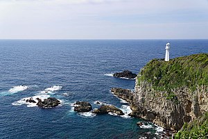
Cape Ashizuri
Distance: Approx. 9314 meters
Latitude and longitude: 32.723829,133.020337
Cape Ashizuri (足摺岬, Ashizuri-misaki) is a headland at the southernmost tip of the Japanese island of Shikoku, in the city of Tosashimizu, Kōchi Prefecture. The promontory extends into the Pacific Ocean and is situated within Ashizuri-Uwakai National Park. Above the cape is Cape Ashizuri Lighthouse, which started operating in 1914, and two observatories, while a short distance inland stand Kongōfuku-ji, the thirty-eighth temple on the Shikoku Pilgrimage, and a bronze statue of Nakahama Manjirō, who was born nearby.

Kongōfuku-ji
Distance: Approx. 9023 meters
Latitude and longitude: 32.726028,133.018556
Kongōfuku-ji (金剛福寺) is a Buzan Shingon temple in Tosashimizu, Kōchi Prefecture, Japan. Temple 38 on the Shikoku 88 temple pilgrimage, the deity that is worshipped at this temple is Sahasra-bhuja, or Senju Kannon Bosatsu (千手観音菩薩) in Japanese. The temple is said to have been founded by Gyōki in 822.

Iburikawa Dam
Dam in Kochi Prefecture, Japan
Distance: Approx. 1954 meters
Latitude and longitude: 32.80055556,132.95027778
Iburikawa Dam (Japanese: 以布利川ダム) is a gravity dam located in Kochi Prefecture in Japan. The dam is used for flood control and water supply. The catchment area of the dam is 0.7 km2.
Weather in this IP's area
broken clouds
5 Celsius
-0 Celsius
5 Celsius
5 Celsius
1015 hPa
56 %
1015 hPa
1012 hPa
10000 meters
10.02 m/s
17.74 m/s
307 degree
64 %