Country:
 Mauritius
Region:
City:
Latitude and Longitude:
Time Zone:
Postal Code:
IP information under different IP Channel
ip-api
Country
Region
City
ASN
Time Zone
ISP
Blacklist
Proxy
Latitude
Longitude
Postal
Route
IPinfo
Country
Region
City
ASN
Time Zone
ISP
Blacklist
Proxy
Latitude
Longitude
Postal
Route
MaxMind
Country
Region
City
ASN
Time Zone
ISP
Blacklist
Proxy
Latitude
Longitude
Postal
Route
Luminati
Country
MUASN
Time Zone
Indian/Mauritius
ISP
MauritiusTelecom
Latitude
Longitude
Postal
db-ip
Country
Region
City
ASN
Time Zone
ISP
Blacklist
Proxy
Latitude
Longitude
Postal
Route
ipdata
Country
Region
City
ASN
Time Zone
ISP
Blacklist
Proxy
Latitude
Longitude
Postal
Route
Popular places and events near this IP address
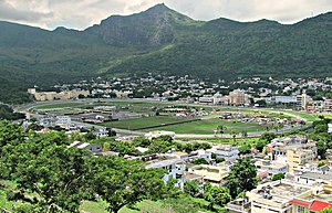
Port Louis
Capital of Mauritius
Distance: Approx. 172 meters
Latitude and longitude: -20.16444444,57.50416667
Port Louis (French: Port-Louis, [pɔʁ lwi] ; Mauritian Creole: Polwi or Porlwi, [poːlwi]) is the capital and most populous city of Mauritius, mainly located in the Port Louis District, with a small western part in the Black River District. Port Louis is the country's financial and political centre. It is administered by the Municipal City Council of Port Louis.

Jummah Mosque (Mauritius)
Mosque in Port Louis, Mauritius
Distance: Approx. 343 meters
Latitude and longitude: -20.15986111,57.50486111
The Jummah Mosque (Arabic: مسجد جمعة) formerly "Mosque of the Arabs", is a mosque in Port Louis, Mauritius dating from the 1850s. The building combines Indian, Creole and Islamic architecture. The Jummah Mosque houses the remains of Jamal Shah (a pir from Kutch, India) in a marble tomb next to the mosque.
National Assembly (Mauritius)
Parliament of Mauritius
Distance: Approx. 105 meters
Latitude and longitude: -20.163,57.5033
The National Assembly (French: Assemblée nationale) is Mauritius's unicameral legislature, which was called the Legislative Assembly from 1968 until 1992, when the country became a republic. Prior to 1968 and under British rule it was known as the Legislative Council. The Constitution of Mauritius provides for the parliament of Mauritius to consist of the President and the National Assembly.

Bank of Mauritius Tower
Skyscraper in Port Louis, the capital of Mauritius, and a home to Bank of Mauritius
Distance: Approx. 131 meters
Latitude and longitude: -20.1618405,57.503752
The Bank of Mauritius Tower (also known as Bank of Mauritius Building or Bank of Mauritius Headquarters) is a skyscraper in Port Louis, the capital of Mauritius, and a home to Bank of Mauritius. It is the tallest building of the country. When measured to roof, it stands at 98 m (321 ft) and to pinnacle at 124 m (407 ft).
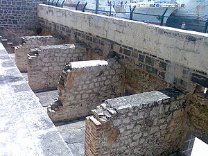
Aapravasi Ghat
Building complex in Port Louis, Mauritius
Distance: Approx. 495 meters
Latitude and longitude: -20.158611,57.503056
The Immigration Depot is a building complex located in Port Louis, Mauritius, the first British colony to receive indentured, or contracted, labour workforce from many countries. From 1849 to 1923, half a million Indian indentured labourers passed through the Immigration Depot, to be transported to plantations throughout the British Empire. The large-scale migration of the labourers left an indelible mark on the societies of many former British colonies, with Indians constituting a substantial proportion of their national populations.

State Bank Tower
Offices in Port Louis, Mauritius
Distance: Approx. 322 meters
Latitude and longitude: -20.16194444,57.50138889
The State Bank Tower is a high-rise building in the capital city of Mauritius, Port Louis. The 16-storey tower contrary to popular belief, is not the tallest building in Port Louis. It is the fourth tallest building and only steel frame skeleton high-rise on the island.

Roman Catholic Diocese of Port-Louis
Catholic diocese in Mauritius
Distance: Approx. 301 meters
Latitude and longitude: -20.1640937,57.5068831
The Diocese of Port-Louis (Latin: Portus Ludovici; French: Diocèse de Port-Louis) is a Latin Church ecclesiastical territory or diocese of the Catholic Church located in the city of Port Louis, the capital city of Mauritius.
Municipal City Council of Port Louis
Local authority for Port Louis, Mauritius
Distance: Approx. 167 meters
Latitude and longitude: -20.164386,57.504104
The Municipal City Council of Port Louis (French: Conseil Municipal de Port Louis), also known as Municipality, is the local authority responsible for the administration of the city of Port Louis, Port Louis District, Mauritius. The Lord Mayor is Daniel Laurent and the Deputy Lord Mayor Marie Désiré Audie Paul Travailleur.

Radio One (Mauritius)
Private Radio Station in Mauritius
Distance: Approx. 548 meters
Latitude and longitude: -20.165768,57.500034
Radio One (R1) is the first private radio station in Mauritius, owned and broadcast by Viva Voce Ltd. It started operations in 2002 with a Private Commercial Free to Air FM Radio Broadcasting Licence issued by the Independent Broadcasting Authority- Mauritius. Radio One is popularly known as the news and entertainment radio channel.

St. Louis Cathedral, Port-Louis
Church in Port Louis, Mauritius
Distance: Approx. 291 meters
Latitude and longitude: -20.1645,57.5065
St. Louis Cathedral (French: Cathédrale Saint-Louis de Port-Louis, Mauritian Creole: Katedral Sin Lwi) is a Roman Catholic cathedral in Port Louis, Mauritius, the seat of the bishop of Port-Louis. Several churches have been built in succession at this location.

Natural History Museum, Port Louis
Museum in Port Louis, Mauritius
Distance: Approx. 205 meters
Latitude and longitude: -20.16316667,57.50236111
The Natural History Museum is a museum in Port Louis, Mauritius.
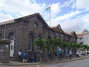
Mauritius Postal Museum
Postal Museum
Distance: Approx. 430 meters
Latitude and longitude: -20.15996,57.50163
The Mauritius Postal Museum is the Postal museum in Port Louis, the capital city of Mauritius.
Weather in this IP's area
light rain
21 Celsius
22 Celsius
21 Celsius
22 Celsius
1018 hPa
88 %
1018 hPa
1015 hPa
10000 meters
4.53 m/s
6.14 m/s
117 degree
71 %
05:44:57
18:09:43