201.76.5.15 - IP Lookup: Free IP Address Lookup, Postal Code Lookup, IP Location Lookup, IP ASN, Public IP
Country:
Region:
City:
Location:
Time Zone:
Postal Code:
ISP:
ASN:
language:
User-Agent:
Proxy IP:
Blacklist:
IP information under different IP Channel
ip-api
Country
Region
City
ASN
Time Zone
ISP
Blacklist
Proxy
Latitude
Longitude
Postal
Route
db-ip
Country
Region
City
ASN
Time Zone
ISP
Blacklist
Proxy
Latitude
Longitude
Postal
Route
IPinfo
Country
Region
City
ASN
Time Zone
ISP
Blacklist
Proxy
Latitude
Longitude
Postal
Route
IP2Location
201.76.5.15Country
Region
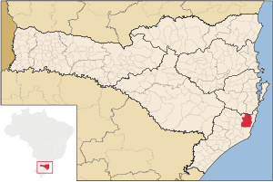
santa catarina
City
bananal
Time Zone
America/Sao_Paulo
ISP
Language
User-Agent
Latitude
Longitude
Postal
ipdata
Country
Region
City
ASN
Time Zone
ISP
Blacklist
Proxy
Latitude
Longitude
Postal
Route
Popular places and events near this IP address

Laguna, Santa Catarina
Municipality in Brazil
Distance: Approx. 8707 meters
Latitude and longitude: -28.4825,-48.78083333
Laguna is a Brazilian municipality located in the southern state of Santa Catarina, 120 kilometers south of the state's capital, Florianópolis, and north east of Porto Alegre. The population is 46,122 (2020 est.) in an area of 336.4 km². Elevation is 2 m.
Tubarão River
Distance: Approx. 9793 meters
Latitude and longitude: -28.50277778,-48.78861111
The Tubarão River is a river in the Brazilian state of Santa Catarina.

Juliana Republic
Short-lived republic in 19th century Brazil
Distance: Approx. 8962 meters
Latitude and longitude: -28.46666667,-48.76666667
The Juliana Republic (Portuguese: República Juliana) or the Catarinense Republic (República Catarinense), fully and officially the Free and Independent Catarinense Republic (República Catarinense Livre e Independente), was a revolutionary state that existed between 29 July and 15 November 1839, in the province of Santa Catarina of the Empire of Brazil. The Republic was proclaimed in an extension of the Ragamuffin War started in the neighboring province of Rio Grande do Sul, where the Rio-Grandense Republic had already been created. Forces of the revolutionary Riograndense Republic, led by General David Canabarro and Italian revolutionary Giuseppe Garibaldi, with help from the local population, conquered the harbor city of Laguna on 22 July 1839, in a battle known as the Capture of Laguna.

Imaruí
Municipality in South, Brazil
Distance: Approx. 9831 meters
Latitude and longitude: -28.35,-48.81666667
Imaruí is a municipality in the state of Santa Catarina in the South region of Brazil. The municipality contains part of the 84,130 hectares (207,900 acres) Serra do Tabuleiro State Park, a protected area created in 1975. The lushly-forested park protects the sources of the Vargem do Braço, Cubatão and D'Una rivers, which supply most of the drinking water for greater Florianópolis and the south coast region.

Pescaria Brava
Municipality in South, Brazil
Distance: Approx. 6449 meters
Latitude and longitude: -28.38333333,-48.88333333
Pescaria Brava is a municipality in the state of Santa Catarina in the South region of Brazil. The municipality was established in January 2013.
Weather in this IP's area
overcast clouds
22 Celsius
23 Celsius
22 Celsius
22 Celsius
1014 hPa
95 %
1014 hPa
1008 hPa
10000 meters
2.43 m/s
6.86 m/s
252 degree
98 %