201.76.15.40 - IP Lookup: Free IP Address Lookup, Postal Code Lookup, IP Location Lookup, IP ASN, Public IP
Country:
Region:
City:
Location:
Time Zone:
Postal Code:
IP information under different IP Channel
ip-api
Country
Region
City
ASN
Time Zone
ISP
Blacklist
Proxy
Latitude
Longitude
Postal
Route
Luminati
Country
Region
sc
City
criciuma
ASN
Time Zone
America/Sao_Paulo
ISP
Contato Internet EIRELI
Latitude
Longitude
Postal
IPinfo
Country
Region
City
ASN
Time Zone
ISP
Blacklist
Proxy
Latitude
Longitude
Postal
Route
IP2Location
201.76.15.40Country
Region
santa catarina
City
forquilhinha
Time Zone
America/Sao_Paulo
ISP
Language
User-Agent
Latitude
Longitude
Postal
db-ip
Country
Region
City
ASN
Time Zone
ISP
Blacklist
Proxy
Latitude
Longitude
Postal
Route
ipdata
Country
Region
City
ASN
Time Zone
ISP
Blacklist
Proxy
Latitude
Longitude
Postal
Route
Popular places and events near this IP address

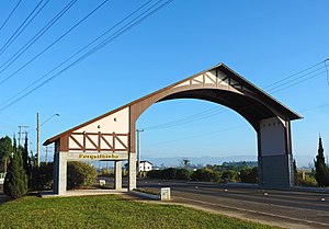
Forquilhinha
Distance: Approx. 1855 meters
Latitude and longitude: -28.76416667,-49.47222222
Forquilhinha is a municipality in the Brazilian state of Santa Catarina. In 2020, it had a population of 27,211 inhabitants. It covers an area of 184,557 km2 at an altitude of 42 meters above sea level.
São Bento River (Mãe Luzia River tributary)
River in Brazil
Distance: Approx. 3138 meters
Latitude and longitude: -28.73333333,-49.5
The São Bento River is a river of Santa Catarina state in southeastern Brazil. It is a tributary of the Mãe Luzia River.

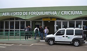
Diomício Freitas Airport
Airport in Forquilhinha, Brazil
Distance: Approx. 5224 meters
Latitude and longitude: -28.72583333,-49.42472222
Diomício Freitas/Forquilhinha Airport (IATA: CCM, ICAO: SSIM) formerly SBCM, is the airport serving Criciúma, Brazil, located in the adjoining municipality of Forquilhinha. It is named after Diomício Manoel de Freitas (1911-1981), a local entrepreneur and politician. It is operated by Infracea.

Universidade do Extremo Sul Catarinense
Distance: Approx. 8077 meters
Latitude and longitude: -28.7013,-49.4084
The Universidade do Extremo Sul Catarinense (Unesc) is a community university, located in the municipality of Criciúma, in the southern part of Santa Catarina, Brazil. It works through education, research and extension in different areas of knowledge. It was the first institution of higher education to be deployed in the southern state of Santa Catarina.
Weather in this IP's area
overcast clouds
22 Celsius
22 Celsius
22 Celsius
22 Celsius
1006 hPa
98 %
1006 hPa
1002 hPa
10000 meters
2.04 m/s
5.26 m/s
266 degree
95 %