Country:
Region:
City:
Latitude and Longitude:
Time Zone:
Postal Code:
IP information under different IP Channel
ip-api
Country
Region
City
ASN
Time Zone
ISP
Blacklist
Proxy
Latitude
Longitude
Postal
Route
Luminati
Country
ASN
Time Zone
America/Caracas
ISP
Telecomunicaciones MOVILNET
Latitude
Longitude
Postal
IPinfo
Country
Region
City
ASN
Time Zone
ISP
Blacklist
Proxy
Latitude
Longitude
Postal
Route
db-ip
Country
Region
City
ASN
Time Zone
ISP
Blacklist
Proxy
Latitude
Longitude
Postal
Route
ipdata
Country
Region
City
ASN
Time Zone
ISP
Blacklist
Proxy
Latitude
Longitude
Postal
Route
Popular places and events near this IP address
El Ávila National Park
Venezuelan national park
Distance: Approx. 1593 meters
Latitude and longitude: 10.53333333,-66.86666667
The Ávila National Park, officially known as Waraira Repano National Park for its indigenous Cariban name, protects part of the Cordillera de la Costa Central mountain range, in the coastal region of central-northern Venezuela. The area's highest elevation is Pico Naiguatá, at 2,765 meters (9,072 ft) above sea level.
Colegio Humboldt, Caracas
School in Caracas, Venezuela
Distance: Approx. 1180 meters
Latitude and longitude: 10.51227,-66.867301
Colegio Humboldt, Caracas is a German school located in Caracas, Venezuela.

Teleférico de Caracas
Distance: Approx. 1703 meters
Latitude and longitude: 10.5124,-66.8867
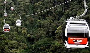
The Teleférico de Caracas is a gondola lift that ascends El Ávila Mountain within El Ávila National Park, in Caracas, Venezuela.
Israelite Association of Venezuela
Jewish organization in Venezuela
Distance: Approx. 2906 meters
Latitude and longitude: 10.499,-66.8883
The Israelite Association of Venezuela (Spanish: Asociación Israelita de Venezuela), known as Tiferet Israel, is an association for Sephardic Jews living in Venezuela. Founded in the 1920s in Caracas, it is the oldest surviving Jewish organization in Venezuela. The association supports two synagogues, the Tiféret Israel Synagogue and the Bet-El Synagogue, both in Caracas.
Apostolic Nunciature to Venezuela
Diplomatic Mission of the Holy See in Venezuela
Distance: Approx. 2516 meters
Latitude and longitude: 10.501,-66.88477778
The Apostolic Nunciature to Venezuela is the diplomatic mission of the Holy See to Venezuela, formally established in 1921. The most recent Apostolic Nuncio is Archbishop Aldo Giordano, who was named to the position by Pope Francis on 26 October 2013. The Apostolic Nunciature to the Bolivarian Republic of Venezuela is an ecclesiastical office of the Catholic Church in Venezuela, with the rank of an embassy.

La Chiquinquirá Church (Caracas)
Distance: Approx. 2178 meters
Latitude and longitude: 10.50154722,-66.87725556
La Chiquinquirá Church (Spanish: Iglesia La Chiquinquirá) is a church in Caracas, Venezuela. La Chiquinquirá Church is the largest Catholic church in Caracas, located in a fortress-like building with a high tower. The church contains some notable statues and paintings.
Radio Nacional de Venezuela
Government radio station in Venezuela
Distance: Approx. 2235 meters
Latitude and longitude: 10.50166667,-66.8675
Radio Nacional de Venezuela is a government radio station in Venezuela. Broadcasting began in 1936. The station is currently run by the Venezuelan governments Ministry of Popular Power for Communication and Information (MINCI).
Polar Towers
Two-tower building complex in Venezuela
Distance: Approx. 2909 meters
Latitude and longitude: 10.4979,-66.8865
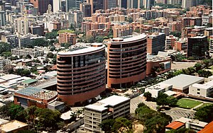
Polar Towers is a complex of two towers located in Plaza Venezuela, east of Caracas, Venezuela. It is the headquarters of Empresas Polar, and is formed by the east tower and the west tower.

La Castellana, Caracas
Neighborhood in Caracas, Venezuela
Distance: Approx. 2758 meters
Latitude and longitude: 10.50333333,-66.85583333
La Castellana is a district in Caracas, Venezuela, located in the northeast part of the city, La Castellana is bordered on the south by Chacao, on the east by Altamira (Caracas) neighbourhood, on the west by Caracas Country Club and Campo Alegre neighbourhood and on the north by El Ávila National Park. It has an approximate surface of 98 hectares (0.987 square kilometers).

Tiféret Israel Synagogue
Orthodox synagogue in Caracas, Venezuela
Distance: Approx. 2906 meters
Latitude and longitude: 10.499,-66.8883
The Tiféret Israel Synagogue (Hebrew: בית הכנסת תפארת ישראל; Spanish: Sinagoga Tiféret Israel) is a Jewish synagogue located in El Recreo, close to Plaza Venezuela in Caracas, capital of Venezuela. It is also the headquarters of the Israelite Association of Venezuela.
St. Ignatius of Loyola College, Caracas
Private primary and secondary school in Venezuela
Distance: Approx. 2948 meters
Latitude and longitude: 10.49944444,-66.85777778
St. Ignatius of Loyola College, Caracas, (Colegio San Ignacio de Loyola) is a private Catholic primary and secondary school located in Caracas, Venezuela Founded by the Jesuits in 1923, the school is coeducational, and covers pre-primary through high school.

Plaza Venezuela station
Caracas metro station
Distance: Approx. 2892 meters
Latitude and longitude: 10.49611111,-66.88191667
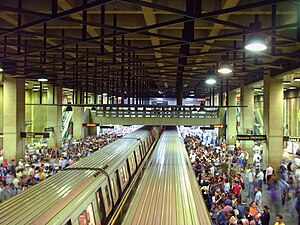
Plaza Venezuela is a Caracas Metro station on Lines 1 and 3. The Line 1 station was opened on 27 March 1983 as part of the extension of the line from La Hoyada to Chacaíto. The station is between Colegio de Ingenieros and Sabana Grande.
Weather in this IP's area
overcast clouds
20 Celsius
20 Celsius
18 Celsius
20 Celsius
1011 hPa
88 %
1011 hPa
865 hPa
10000 meters
1.03 m/s
100 degree
98 %
06:20:17
18:02:10

