Country:
Region:
City:
Latitude and Longitude:
Time Zone:
Postal Code:
IP information under different IP Channel
ip-api
Country
Region
City
ASN
Time Zone
ISP
Blacklist
Proxy
Latitude
Longitude
Postal
Route
Luminati
Country
Region
lim
City
villa
ASN
Time Zone
America/Lima
ISP
HUASCARAN INVESTMENT GROUP S.A.C.
Latitude
Longitude
Postal
IPinfo
Country
Region
City
ASN
Time Zone
ISP
Blacklist
Proxy
Latitude
Longitude
Postal
Route
db-ip
Country
Region
City
ASN
Time Zone
ISP
Blacklist
Proxy
Latitude
Longitude
Postal
Route
ipdata
Country
Region
City
ASN
Time Zone
ISP
Blacklist
Proxy
Latitude
Longitude
Postal
Route
Popular places and events near this IP address
Pachacamac
Archaeological site in Peru
Distance: Approx. 5634 meters
Latitude and longitude: -12.25666667,-76.90027778
Pachacámac (Quechua: Pachakamaq) is an archaeological site 40 kilometres (25 mi) southeast of Lima, Peru in the Valley of the Lurín River. The site was first settled around A.D. 200 and was named after the "Earth Maker" creator god Pacha Kamaq. The site flourished for about 1,300 years until the Spanish invaded.
Scientific University of the South
Distance: Approx. 3861 meters
Latitude and longitude: -12.2208,-76.9784
The Universidad Científica del Sur or Scientific University of the South (UCSUR) is a private institution of higher education, located at 19 km south from the city of Lima, nearby Pantanos de Villa Reserved Zone. The university was founded and recognized in 1997 by education representatives, led by José Carlos Dextre. It started activities by offering Medicine and Systems Engineering programmes.

Pantanos de Villa Wildlife Refuge
Protected area in Lima, Peru
Distance: Approx. 5200 meters
Latitude and longitude: -12.2137,-76.989
Pantanos de Villa Wildlife Refuge is a protected area of marshes located in the district of Chorrillos, within the city of Lima, Peru with an extension of 263.27 hectares (2.63 km2).

Battle of San Juan and Chorrillos
1881 battle of the War of the Pacific
Distance: Approx. 6169 meters
Latitude and longitude: -12.1756,-76.9564
The Battle of San Juan, also known as the Battle of San Juan and Chorrillos, was the first of two battles in the Lima Campaign during the War of the Pacific, and was fought on 13 January 1881. This battle is really a group of smaller, yet fierce confrontations at the defensive strongholds of Villa, Chorrillos, Santiago de Surco, San Juan de Miraflores, Santa Teresa and Morro Solar. The Chilean army led by Gen.

Lurín River
River in Peru
Distance: Approx. 6696 meters
Latitude and longitude: -12.275,-76.9036
The Lurín River is a 108.57 kilometres (67.46 mi) long watercourse located in the Lima Region of Peru. It originates in the glaciers and lagoons of the western Andes. It is known as the Chalilla River until joining the Taquía creek where it receives its common name.

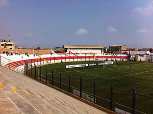
Estadio Iván Elías Moreno
Distance: Approx. 1462 meters
Latitude and longitude: -12.22010556,-76.934925
Estadio Iván Elías Moreno is a multi-purpose stadium in the Villa El Salvador District, Lima, Peru. It is currently used by football team Club Deportivo Municipal. The stadium holds 10,000 people.

2020 Villa El Salvador explosion
2020 explosion in Peru
Distance: Approx. 2516 meters
Latitude and longitude: -12.20819444,-76.95122222
On January 23, 2020, a gas leak from a truck transporting liquefied petroleum gas caused an explosion in Villa El Salvador, Lima metropolitan area, Peru. The subsequent fires affected at least 20 homes and several vehicles.

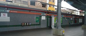
Villa El Salvador metro station
Lima metro station
Distance: Approx. 3299 meters
Latitude and longitude: -12.23388889,-76.91408333
Villa El Salvador is a Lima and Callao Metro station that serves as the southern terminus of Line 1. The adjacent station is Parque Industrial. The station was inaugurated on 28 April 1990 as part of the first section of the line between Villa El Salvador and Atocongo.

Parque Industrial metro station
Lima metro station
Distance: Approx. 3748 meters
Latitude and longitude: -12.19627778,-76.93997222
Parque Industrial is a Lima and Callao Metro station on Line 1. The station is located between Villa El Salvador and Pumacahua. It was inaugurated on 28 April 1990 as part of the first section of the line between Villa El Salvador and Atocongo.

Pumacahua metro station
Lima metro station
Distance: Approx. 5288 meters
Latitude and longitude: -12.18227778,-76.94691667
Pumacahua is a Lima and Callao Metro station on Line 1. The station is located between Parque Industrial and Villa María. It was inaugurated on 28 April 1990 as part of the first section of the line between Villa El Salvador and Atocongo.

Villa María metro station
Lima metro station
Distance: Approx. 6751 meters
Latitude and longitude: -12.16936111,-76.95030556
Villa María is a Lima and Callao Metro station on Line 1. The station is located between Pumacahua and María Auxiliadora. It was inaugurated on 28 April 1990 as part of the first section of the line between Villa El Salvador and Atocongo.

National Museum of Peru
National museum in Lima, Peru
Distance: Approx. 4554 meters
Latitude and longitude: -12.25425407,-76.91061959
The National Museum of Peru is a national museum in Lurín District, Lima, Peru, located within the archaeological zone of Pachacamac. The museum will hold over a half million artifacts of the Pre-Columbian era and Inca Empire, ranging back to 5,000 BCE. It opened in July 2021 as part of Peru's bicentennial celebrations and is capable of accepting 15,000 guests per day.
Weather in this IP's area
overcast clouds
20 Celsius
21 Celsius
20 Celsius
20 Celsius
1014 hPa
79 %
1014 hPa
1001 hPa
7949 meters
4.4 m/s
3.88 m/s
188 degree
94 %
05:32:17
18:12:31