Country:
Region:
City:
Latitude and Longitude:
Time Zone:
Postal Code:
IP information under different IP Channel
ip-api
Country
Region
City
ASN
Time Zone
ISP
Blacklist
Proxy
Latitude
Longitude
Postal
Route
Luminati
Country
Region
pe
City
jaboataodosguararapes
ASN
Time Zone
America/Recife
ISP
INETWORKS LTDA
Latitude
Longitude
Postal
IPinfo
Country
Region
City
ASN
Time Zone
ISP
Blacklist
Proxy
Latitude
Longitude
Postal
Route
db-ip
Country
Region
City
ASN
Time Zone
ISP
Blacklist
Proxy
Latitude
Longitude
Postal
Route
ipdata
Country
Region
City
ASN
Time Zone
ISP
Blacklist
Proxy
Latitude
Longitude
Postal
Route
Popular places and events near this IP address
American School of Recife
Private school in Recife, Brazil
Distance: Approx. 7966 meters
Latitude and longitude: -8.1328,-34.9061
The American School of Recife (Portuguese: Escola Americana do Recife, or EAR) is an American school in the city of Recife, Brazil. The school, founded in 1957, is a private, non-profit, coeducational day school. It offers an instructional program from early childhood through grade 12 for students of all nationalities.

Second Battle of Guararapes
Part of the Pernambucana Insurrection (1649)
Distance: Approx. 5486 meters
Latitude and longitude: -8.11222222,-35.01555556
The Second Battle of Guararapes was the second and decisive battle in the Insurrection of Pernambuco between Dutch and Portuguese forces in February 1649 at Jaboatão dos Guararapes in Pernambuco. The defeat convinced the Dutch "that the Portuguese were formidable opponents, something which they had hitherto refused to concede." The Dutch still retained a presence in Brazil until 1654 and a treaty was signed in 1661.

Recife/Guararapes–Gilberto Freyre International Airport
Brazilian airport
Distance: Approx. 6341 meters
Latitude and longitude: -8.12638889,-34.92277778
Aeroporto Internacional do Recife/Guararapes–Gilberto Freyre (IATA: REC, ICAO: SBRF) is the airport serving Recife, Brazil. Since December 27, 2001 it is named after the Recife-born Anthropologist and Sociologist Gilberto de Mello Freyre (1900–1987). Some of its facilities are shared with the Recife Air Force Base of the Brazilian Air Force.

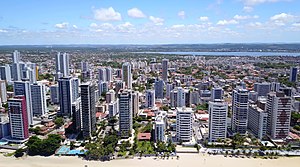
Jaboatão dos Guararapes
Municipality in Northeast, Brazil
Distance: Approx. 5486 meters
Latitude and longitude: -8.11222222,-35.01555556
Jaboatão dos Guararapes (Portuguese pronunciation: [ʒabwaˈtɐ̃w duz ɡwaɾaˈɾapis]) is a city in the state of Pernambuco, Brazil. It is a part of the Recife metro area. The population was 706,867 according to the Brazilian Institute of Geography and Statistics (IBGE) in 2020, making it the second most-populous city in the state of Pernambuco and the 27th in Brazil, ahead of major Brazilian state capitals such as Cuiabá and Aracaju.

Noar Linhas Aéreas Flight 4896
2011 aviation accident
Distance: Approx. 7559 meters
Latitude and longitude: -8.1525,-34.90944444
On 13 July 2011, Noar Linhas Aéreas Flight 4896, a Let L-410 Turbolet passenger aircraft on a domestic service from Recife to Mossoró, Brazil, crashed shortly after take-off in the Boa Viagem neighbourhood of Recife, after suffering an engine failure. All 16 people on board were killed.

Recife Air Force Base
Air base of the Brazilian Air Force
Distance: Approx. 6341 meters
Latitude and longitude: -8.12638889,-34.92277778
Base Aérea do Recife – BARF (IATA: REC, ICAO: SBRF) was a base of the Brazilian Air Force, located in Recife, Brazil. It shared some facilities with Recife/Guararapes–Gilberto Freyre International Airport.

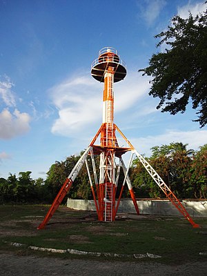
Zeppelin Tower
Brazilian airship station
Distance: Approx. 9247 meters
Latitude and longitude: -8.07833333,-34.92611111
The Zeppelin Tower (Portuguese: Torre do Zeppelin) is located in the neighborhood of Jiquiá, formerly Campo do Jiquiá, in the city of Recife, state of Pernambuco, Brazil. It was the first aeronautical station for airships in South America, and is the only object of its kind still standing in the world.
Weather in this IP's area
few clouds
27 Celsius
30 Celsius
27 Celsius
27 Celsius
1013 hPa
78 %
1013 hPa
1011 hPa
10000 meters
5.14 m/s
110 degree
20 %
04:50:19
17:20:48