Country:
 Mexico
Region:
City:
Latitude and Longitude:
Time Zone:
Postal Code:
IP information under different IP Channel
ip-api
Country
Region
City
ASN
Time Zone
ISP
Blacklist
Proxy
Latitude
Longitude
Postal
Route
IPinfo
Country
Region
City
ASN
Time Zone
ISP
Blacklist
Proxy
Latitude
Longitude
Postal
Route
MaxMind
Country
Region
City
ASN
Time Zone
ISP
Blacklist
Proxy
Latitude
Longitude
Postal
Route
Luminati
Country
MXRegion
mex
City
coacalco
ASN
Time Zone
America/Mexico_City
ISP
Sixsigma Networks Mexico, S.A. de C.V.
Latitude
Longitude
Postal
db-ip
Country
Region
City
ASN
Time Zone
ISP
Blacklist
Proxy
Latitude
Longitude
Postal
Route
ipdata
Country
Region
City
ASN
Time Zone
ISP
Blacklist
Proxy
Latitude
Longitude
Postal
Route
Popular places and events near this IP address

Coacalco de Berriozábal
Municipality in Mexico, Mexico
Distance: Approx. 1340 meters
Latitude and longitude: 19.63333333,-99.09305556
Coacalco de Berriozábal (; simply known as Coacalco) is one of 125 municipalities in the State of Mexico, Mexico. The municipal seat is the city of San Francisco Coacalco. The municipality lies in the Greater Mexico City conurbation, north of Mexico City.
San Pablo de las Salinas
Town in State of Mexico, Mexico
Distance: Approx. 4275 meters
Latitude and longitude: 19.66555556,-99.09166667
San Pablo de las Salinas is an exclave and the second-largest colonia in Tultitlán Municipality in the State of Mexico, Mexico. The neighborhood is part of the Mexico City metropolitan area and had a 2010 census population of 189,453 inhabitants, or 36.15% of the municipal population. The town lies near the northern tip of Mexico City.

Fuentes del Valle
Distance: Approx. 3532 meters
Latitude and longitude: 19.6325,-99.13861111
Fuentes del Valle is the third-largest colonia in Tultitlán Municipality in Mexico State, Mexico. The neighborhood is part of the Mexico City metropolitan area and had a 2010 census population of 74,087 inhabitants. It lies near the northern tip of the Federal District (Distrito Federal), and between the larger Buenavista and San Pablo de las Salinas.

Santiago Teyahualco
Distance: Approx. 5105 meters
Latitude and longitude: 19.66666667,-99.13333333
Santiago Teyahualco is the second-largest town in the municipality of Tultepec in the state of México in Mexico. At the Mexican census of 2005 the town reported a population of 47,547 inhabitants. Santiago Teyahualco, is a town located in Tultepec, State of Mexico, Mexico.
Tultepec
Municipality in Mexico State, Mexico
Distance: Approx. 6651 meters
Latitude and longitude: 19.685,-99.12805556
Tultepec (Nahuatl languages: Tōltepec, Otomi: Nt‘ōkwä) is a city and municipality located in State of Mexico, Mexico. It lies directly north of Mexico City in the northeastern part of the State of Mexico, making it part of the Greater Mexico City urban area. The name comes from Náhuatl meaning 'hill of the 'tule'.

Mexiquense Televisión
Public TV network of the State of Mexico
Distance: Approx. 4268 meters
Latitude and longitude: 19.59227778,-99.11566667
Mexiquense Televisión is the public television network of the Mexican State of Mexico. It is operated by the Sistema Mexiquense de Medios Públicos, previously Sistema de Radio y Televisión Mexiquense, a state agency which also owns six radio stations. It consists of two high-powered television transmitters covering the valleys of Toluca and Mexico, supplemented by 28 retransmitters.

Ecatepec de Morelos
City & Municipality in State of Mexico, Mexico
Distance: Approx. 5207 meters
Latitude and longitude: 19.60972222,-99.06
Ecatepec (Spanish: [ekateˈpek] ), officially Ecatepec de Morelos, is a municipality in the State of Mexico, and is situated in the north part of the Greater Mexico City urban area. The municipal seat is San Cristóbal Ecatepec. The city of Ecatepec is co-extensive with the municipality, comprising 99% of the total population of 1,645,352.

XHCME-FM
Radio station in Coacalco–Melchor Ocampo, State of Mexico
Distance: Approx. 1012 meters
Latitude and longitude: 19.63339,-99.09648
XHCME-FM is a radio station in Melchor Ocampo, State of Mexico. Broadcasting on 103.7 FM, XHCME is owned by Grupo Siete and is known as Radio Crystal with an older-leaning Regional Mexican format.

2016 San Pablito Market fireworks explosion
2016 Explosion at the San Pablito Market in Tultepec, Mexico
Distance: Approx. 4912 meters
Latitude and longitude: 19.66833333,-99.12694444
On 20 December 2016, a fireworks accident occurred at the San Pablito Market in the city of Tultepec, north of Valley of Mexico. At least 42 people were killed in the explosion, and dozens injured.

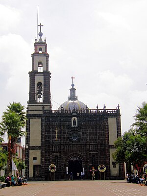
San Francisco de Asís Parish (Coacalco de Berriozábal)
Church in State of Mexico, Mexico
Distance: Approx. 158 meters
Latitude and longitude: 19.63025,-99.10398
San Francisco de Asís Parish (Spanish: Parroquia de San Francisco de Asís) is a Catholic parish church in San Francisco Coacalco, in the municipality of Coacalco de Berriozábal, State of Mexico. It is dedicated to Francis of Assisi, whose feast is on 4 October. The church was opened c. 1580 and was rebuilt c. 1700.

Cosmopol
Shopping mall in Mexico, Mexico
Distance: Approx. 2044 meters
Latitude and longitude: 19.6319,-99.1244
Cosmopol is a shopping mall in Coacalco de Berriozábal, State of Mexico, in the metropolitan area of Mexico City, located along José López Portillo Avenue. The mall was opened in September 2015. It is anchored by Liverpool and Sears, and it has over 210 stores and services and 2,900 parking lots.
Sierra de Guadalupe, Mexico
Mountain range along Central Mexico
Distance: Approx. 5296 meters
Latitude and longitude: 19.58305556,-99.11694444
The Sierra de Guadalupe is a mountain range in Mexico. It is found between the borough of Gustavo A. Madero in northern Mexico City and the municipalities of Cuautitlán Izcalli, Tultitlán, Coacalco, Ecatepec and Tlalnepantla, in the State of Mexico. Its highest peak is at 3,055 meters (10,023 ft).
Weather in this IP's area
few clouds
10 Celsius
10 Celsius
10 Celsius
10 Celsius
1020 hPa
78 %
1020 hPa
782 hPa
10000 meters
0.78 m/s
1.1 m/s
34 degree
12 %
06:31:56
18:10:39