Country:
 Brazil
Region:
City:
Latitude and Longitude:
Time Zone:
Postal Code:
IP information under different IP Channel
ip-api
Country
Region
City
ASN
Time Zone
ISP
Blacklist
Proxy
Latitude
Longitude
Postal
Route
IPinfo
Country
Region
City
ASN
Time Zone
ISP
Blacklist
Proxy
Latitude
Longitude
Postal
Route
MaxMind
Country
Region
City
ASN
Time Zone
ISP
Blacklist
Proxy
Latitude
Longitude
Postal
Route
Luminati
Country
BRASN
Time Zone
America/Sao_Paulo
ISP
BR.Digital Provider
Latitude
Longitude
Postal
db-ip
Country
Region
City
ASN
Time Zone
ISP
Blacklist
Proxy
Latitude
Longitude
Postal
Route
ipdata
Country
Region
City
ASN
Time Zone
ISP
Blacklist
Proxy
Latitude
Longitude
Postal
Route
Popular places and events near this IP address
Independência, Porto Alegre
Neighborhood in Porto Alegre, Rio Grande do Sul, Brazil
Distance: Approx. 1081 meters
Latitude and longitude: -30.029,-51.213
Independência (literally Independence in English) is a tiny neighborhood of the city of Porto Alegre, the state capital of Rio Grande do Sul in Brazil. The neighborhood was created by Law 2022 of December 7, 1959. There is located a highly regarded and traditional private school of the city, the Marista Nossa Senhora do Rosário school.

Federal University of Health Sciences of Porto Alegre
Distance: Approx. 1568 meters
Latitude and longitude: -30.031576,-51.220472
The Federal University of Health Sciences of Porto Alegre (Portuguese: Universidade Federal de Ciências da Saúde de Porto Alegre, UFCSPA), formerly known as Fundação Faculdade Federal de Ciências Médicas de Porto Alegre and Faculdade Católica de Medicina de Porto Alegre, is a federal institution of higher education and research on health sciences located in Porto Alegre, Brazil.

Santa Casa de Misericordia Hospital
Hospital in Porto Alegre, Brazil
Distance: Approx. 1558 meters
Latitude and longitude: -30.0305,-51.2222
Santa Casa de Misericordia Hospital is a major Hospital based in Porto Alegre, Brazil. It is reference in Latin America for transplants and genetic research. It is a university hospital linked to the Federal University of Health Sciences of Porto Alegre.

Moinhos de Vento Park
Park in Porto Alegre, Brazil
Distance: Approx. 1448 meters
Latitude and longitude: -30.0275,-51.20083333
Moinhos de Vento Park (Portuguese: Parque Moinhos de Vento, literally "Windmills Park"), popularly known as Parcão (literally "Big Park"), is a well-known park in Porto Alegre. It is located in the Moinhos de Vento neighborhood. The park structure consists of soccer, tennis and volleyball fields, gym equipment, a playground, a kids library, a pond with fish, turtles and ducks, a playground, and a replica of an Azorean windmill.

Moinhos de Vento
Bairro in Rio Grande do Sul, Brazil
Distance: Approx. 1101 meters
Latitude and longitude: -30.02361111,-51.20222222
Moinhos de Vento (literally Windmills in English) is a neighbourhood of the city of Porto Alegre, the state capital of Rio Grande do Sul in Brazil. It was created by the law number 2022 of December 7, 1959. Moinhos de Vento got its name because Azorean immigrant families built their windmills in its area during the 18th century.
Bom Fim
Neighborhood in Porto Alegre, Brazil
Distance: Approx. 1470 meters
Latitude and longitude: -30.0325,-51.21222222
Bom Fim (meaning Good End in English) is a neighborhood in the city of Porto Alegre, the state capital of Rio Grande do Sul in Brazil. It was created by the law number 2022 from December 7, 1959.
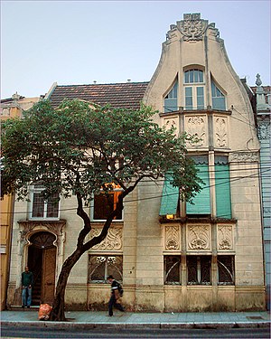
Godoy House
Historic site in RS, Brazil
Distance: Approx. 1180 meters
Latitude and longitude: -30.02922222,-51.21680556
The Godoy House is a historic building on Independência Avenue in the city of Porto Alegre, Rio Grande do Sul, Brazil. The house is one of the rare remaining buildings in the Art Nouveau style in Porto Alegre, dating from 1907.

Church of Our Lady of the Conception (Porto Alegre)
Catholic Church in Brazil
Distance: Approx. 1272 meters
Latitude and longitude: -30.02916667,-51.21916667
The Church of Our Lady of the Conception is a temple of the Catholic Church located on Independência Avenue, in front of the Dom Sebastião Square, in Porto Alegre, Brazil. It is one of the oldest churches in the city and the one that best preserves its original appearance, containing a rich internal decoration in gilded woodcarving and statuary, besides being a listed property by the City Hall.

Beneficência Portuguesa de Porto Alegre
Brazilian hospital
Distance: Approx. 1244 meters
Latitude and longitude: -30.02904,-51.21883
The Beneficência Portuguesa de Porto Alegre, originally Sociedade Beneficente e Hospitalar da Colônia Portuguesa de Porto Alegre (English: Hospital and Charitable Society of the Portuguese Colony of Porto Alegre), is a Brazilian philanthropic hospital institution in the city of Porto Alegre, state of Rio Grande do Sul. It is located at 270 Independência Avenue, in the Independência neighborhood. In 1977, the historical building was included by the City Hall in the Inventory of Real Estate Assets of Historical and Cultural Value and of Expressive Tradition.

Ely Building
Brazilian historic building
Distance: Approx. 1036 meters
Latitude and longitude: -30.02608,-51.21986
The Ely Building is a historic construction located in the Brazilian city of Porto Alegre, capital of Rio Grande do Sul, considered a cultural heritage of the city. The building, located at 283 Conceição Street, next to the bus station, was designed and erected between 1922 and 1923 by the German-Brazilian architect Theodor Wiederspahn, to be a store of the merchant Nicolau Ely, who became rich in the fabric trade. Originally, Ely kept his business on the first floor and rented out the upper floors for offices.

Dom Sebastião Square
Brazilian square
Distance: Approx. 1341 meters
Latitude and longitude: -30.03,-51.21888889
Dom Sebastião Square is located in the Brazilian city of Porto Alegre, capital of the state of Rio Grande do Sul. It is bordered on the north by Independência Avenue, on the east by Dom Sebastião Lane, on the south by Irmão José Otão Street and on the west by Sarmento Leite Street. It was named after the diocesan bishop Dom Sebastião Dias Laranjeira.

Argentina Palace
Historic building in Rio Grande do Sul, Brazil
Distance: Approx. 1130 meters
Latitude and longitude: -30.02944444,-51.21277778
Argentina Palace (Portuguese: Palacete Argentina) is a historic building located in the Brazilian city of Porto Alegre, in the state of Rio Grande do Sul. It is a heritage site listed by the National Institute of Historic and Artistic Heritage (IPHAN).
Weather in this IP's area
overcast clouds
19 Celsius
19 Celsius
18 Celsius
19 Celsius
1017 hPa
86 %
1017 hPa
1016 hPa
10000 meters
1.83 m/s
3.15 m/s
130 degree
100 %
05:41:49
18:37:19