Country:
 Mexico
Region:
City:
Latitude and Longitude:
Time Zone:
Postal Code:
IP information under different IP Channel
ip-api
Country
Region
City
ASN
Time Zone
ISP
Blacklist
Proxy
Latitude
Longitude
Postal
Route
IPinfo
Country
Region
City
ASN
Time Zone
ISP
Blacklist
Proxy
Latitude
Longitude
Postal
Route
MaxMind
Country
Region
City
ASN
Time Zone
ISP
Blacklist
Proxy
Latitude
Longitude
Postal
Route
Luminati
Country
MXRegion
cmx
City
miguelhidalgo
ASN
Time Zone
America/Mexico_City
ISP
AT&T COMUNICACIONES DIGITALES S DE RL
Latitude
Longitude
Postal
db-ip
Country
Region
City
ASN
Time Zone
ISP
Blacklist
Proxy
Latitude
Longitude
Postal
Route
ipdata
Country
Region
City
ASN
Time Zone
ISP
Blacklist
Proxy
Latitude
Longitude
Postal
Route
Popular places and events near this IP address

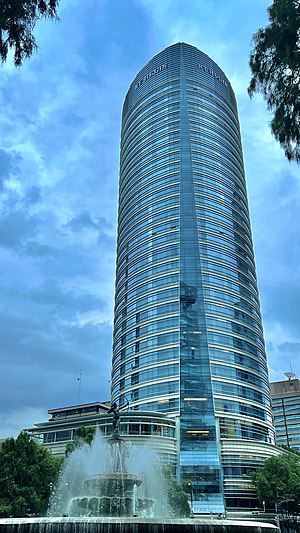
Torre Mayor
Skyscraper in Mexico City, Mexico
Distance: Approx. 463 meters
Latitude and longitude: 19.42416667,-99.17555556
The Torre Mayor is a skyscraper in Mexico City, Mexico that is the eighth tallest building in Mexico with a height of 225 meters (738 feet). From its completion in 2003 until 2010, it was the tallest building in Latin America; it was surpassed by the 236 m (774 ft) high Ocean Two in Panama City, Panama. The Torre Mayor was developed by Canadian businessman Paul Reichmann, who also maintained part ownership until his death in 2013.
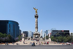
Angel of Independence
Victory column and statue in Mexico City
Distance: Approx. 443 meters
Latitude and longitude: 19.42699983,-99.16770983
The Angel of Independence, most commonly known by the shortened name El Ángel and officially known as Monumento a la Independencia ("Monument to Independence"), is a victory column on a roundabout on the major thoroughfare of Paseo de la Reforma in downtown Mexico City. El Ángel was built in 1910 during the presidency of Porfirio Díaz by architect Antonio Rivas Mercado, to commemorate the centennial of the beginning of Mexico's War of Independence. In later years it was made into a mausoleum for the most important heroes of that war.
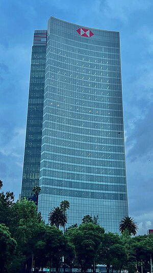
HSBC Tower, Mexico City
Distance: Approx. 375 meters
Latitude and longitude: 19.4278,-99.1686
HSBC Tower (Spanish: Torre HSBC) is a skyscraper office building located on Paseo de la Reforma in Colonia Cuauhtémoc, Cuauhtémoc, Mexico City, Mexico, which is the headquarters of HSBC Mexico. It is located opposite the Angel of Independence, and is home to the around 2,800 HSBC Mexico staff. Construction was completed in 2006, at a cost of around US$150 million.

Torre del Caballito
Office in Paseo de la Reforma, Mexico City
Distance: Approx. 463 meters
Latitude and longitude: 19.42416667,-99.17555556
Torre del Caballito is a skyscraper located on the Paseo de la Reforma #10 at the Cuauhtemoc delegation in Mexico City. It was designed by Grupo Posadas de Mexico. It is 135 metres (443 feet) and 35 storeys tall.
Torre Bicentenario
Skyscraper project
Distance: Approx. 329 meters
Latitude and longitude: 19.42463889,-99.17433333
The Torre Bicentenario (Bicentennial Tower) was a skyscraper project planned for construction in Mexico City. If built, at 300 meters (984 ft) tall, it would surpass the Torre Mayor as the holder of the title of Tallest Building in Mexico and same height as the highest building in Latin America. Torre Bicentenario was officially canceled, as announced by the local government and the involved investors on September 28, 2007.
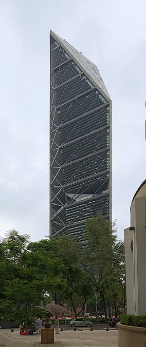
Torre Reforma
Mexico City skyscraper with a height of 807 feet
Distance: Approx. 329 meters
Latitude and longitude: 19.42463889,-99.17433333
The Torre Reforma is a skyscraper in Mexico City with a height of 807 feet (246 m) to the roof and housing 57 stories, in 2016 it became the tallest skyscraper in Mexico City, exceeding both Torre BBVA Bancomer at 771 feet (235 m) located just across the street, and Torre Mayor at 739.5 feet (225.4 m) located next to it. Construction began in May 2008. The complex hosts a restaurant, a shopping mall, entertainment areas and the DOOM International's Reforma Gym.
The St. Regis Mexico City
Skyscrapers in Mexico City
Distance: Approx. 105 meters
Latitude and longitude: 19.42558056,-99.17213056
Freedom Tower (also called the St. Regis Hotel Tower) is a skyscraper located in front of the Diana Fountain roundabout at Paseo de la Reforma 439, Colonia, Cuauhtémoc, Delegación Cuauhtémoc in Mexico City. Its construction began in November 2004 and completed in January 2008.

Pequeño Seúl
Koreatown in Mexico City, Mexico
Distance: Approx. 418 meters
Latitude and longitude: 19.4244,-99.1686
Pequeño Seúl (Korean: 작은 서울; RR: jageun seoul; lit. little Seoul) is a Koreatown in Mexico City. Most of the city's Korean population lives in and around the Zona Rosa.
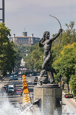
Diana the Huntress Fountain
Fountain and sculpture in Mexico City, Mexico
Distance: Approx. 149 meters
Latitude and longitude: 19.4251879,-99.1716226
The Huntress Diana Fountain (Spanish: Fuente de la Diana Cazadora) stands as a monumental sculptural landmark situated within the roundabout at the intersection of Paseo de la Reforma and Río Misisipí and Sevilla streets. Positioned on the border of the Colonia Cuauhtémoc and Colonia Juárez neighborhoods in Mexico City, this fountain serves as a focal point within the urban fabric of the metropolis. Designed by the Italian architect and sculptor Enrique Alciati, the fountain was unveiled in 1942 and has since become an enduring symbol of Mexico City's cultural heritage and urban landscape.

Embassy of the United Kingdom, Mexico City
Diplomatic mission
Distance: Approx. 468 meters
Latitude and longitude: 19.4258,-99.1675
The Embassy of the United Kingdom in Mexico City is the chief diplomatic mission of the United Kingdom in Mexico. The Embassy is located on Paseo de la Reforma 350 20th Floor, Torre del Angel. The former location of the Embassy was in Rio Lerma 71, in the Colonia Cuauhtémoc neighbourhood.

El Ángel de la Seguridad Social
Sculpture in Mexico City, Mexico
Distance: Approx. 403 meters
Latitude and longitude: 19.4233947,-99.1738657
El Ángel de la Seguridad Social (or The Social Security Angel) is an outdoor 2013 bronze sculpture by Jorge Marín, installed along Mexico City's Paseo de la Reforma, in Mexico. It commemorates the creation of the Mexican Social Security Institute.

Parish of the Holy Child of Peace
Church in Mexico City, Mexico
Distance: Approx. 270 meters
Latitude and longitude: 19.42486111,-99.17
The Parish of the Holy Child of Peace (Spanish: Parroquia del Santo Niño de la Paz) is a historic church located near Paseo de la Reforma and Zona Rosa in Cuauhtémoc, Mexico City, Mexico. It is also known as Praga Parish (Spanish: Parroquia de Praga) because it is found on Praga 11 Street. The church is known for its German neogothic architecture and was recognized as a temple by the Secretariat of the Interior in 1931.
Weather in this IP's area
light rain
20 Celsius
20 Celsius
20 Celsius
20 Celsius
1014 hPa
78 %
1014 hPa
785 hPa
10000 meters
3.58 m/s
30 degree
96 %
06:25:06
18:35:34