Country:
 Mexico
Region:
City:
Latitude and Longitude:
Time Zone:
Postal Code:
IP information under different IP Channel
ip-api
Country
Region
City
ASN
Time Zone
ISP
Blacklist
Proxy
Latitude
Longitude
Postal
Route
IPinfo
Country
Region
City
ASN
Time Zone
ISP
Blacklist
Proxy
Latitude
Longitude
Postal
Route
MaxMind
Country
Region
City
ASN
Time Zone
ISP
Blacklist
Proxy
Latitude
Longitude
Postal
Route
Luminati
Country
MXASN
Time Zone
America/Mexico_City
ISP
AT&T COMUNICACIONES DIGITALES S DE RL
Latitude
Longitude
Postal
db-ip
Country
Region
City
ASN
Time Zone
ISP
Blacklist
Proxy
Latitude
Longitude
Postal
Route
ipdata
Country
Region
City
ASN
Time Zone
ISP
Blacklist
Proxy
Latitude
Longitude
Postal
Route
Popular places and events near this IP address

Tasqueña metro station
Mexico City metro station
Distance: Approx. 1199 meters
Latitude and longitude: 19.344168,-99.142685
Tasqueña (sometimes also spelled Taxqueña) is a station on Line 2 of the Mexico City Metro system. It is located in the Campestre Churubusco neighborhood, within the Coyoacán borough of Mexico City, directly south of the city centre on Avenida Tasqueña and Canal de Miramontes. It is a surface station and the southern terminus of the line.

General Anaya metro station (Mexico City)
Mexico City metro station
Distance: Approx. 2122 meters
Latitude and longitude: 19.353259,-99.145002
General Anaya is a station on Line 2 of the Mexico City Metro system. It is located in the Coyoacán borough of Mexico City, directly south of the city centre in the median of Calzada de Tlalpan, and right next to the Estudios Churubusco. It is a surface station.
Estudios Churubusco
Movie studio in Mexico City
Distance: Approx. 2228 meters
Latitude and longitude: 19.35551,-99.14284
Estudios Churubusco is one of the oldest and largest movie studios in Mexico. It is located in the Churubusco neighborhood of Mexico City.
Anahuacalli Museum
Museum and arts center in Mexico City
Distance: Approx. 1984 meters
Latitude and longitude: 19.3225,-99.14416667
The Diego Rivera Anahuacalli Museum is a museum and arts center in Mexico City, located in the San Pablo de Tepetlapa neighborhood of Coyoacán, 10 minutes by car from the Frida Kahlo Museum, as well as from the tourist neighborhood of this district. The Anahuacalli (from the Nahuatl word, whose meaning is "house surrounded by water"), is a temple of the arts designed by the Mexican muralist Diego Rivera. This museum stands out for its extensive collection of pre-Columbian art, as well as for its Ecological Space that protects endemic flora and fauna.

Secretariat of the Navy
Mexican naval military official
Distance: Approx. 1819 meters
Latitude and longitude: 19.322,-99.128
The Mexican Secretary of the Navy (Spanish: Secretaría de Marina, SEMAR) is a member of the federal executive cabinet as well as the highest-ranking Mexican naval officer with the responsibility of commanding the Mexican Navy (including the Mexican Naval Infantry or ‘marines,’ as well as the Mexican merchant marine service ) and managing the Secretariat of the Navy (the naval ministry and naval civil service). The secretary is appointed by the President of the Republic. Organizes, administers and prepares the Navy.
Instituto Superior de Intérpretes y Traductores
Distance: Approx. 415 meters
Latitude and longitude: 19.3411,-99.1343
The Instituto Superior de Intérpretes y Traductores, S.C. (in English: Superior Institute of Interpreters and Translators), commonly known as ISIT, is a private university located in Mexico City, Mexico. It focuses on interpretation and translation, and it became the first institution in the Americas to academically acknowledge these disciplines as bachelor degrees. ISIT has worked along with Fondo de Cultura Económica (Economic Culture Fund), the Instituto Nacional de Bellas Artes (National Institute of Fine Arts), Asociación de Escritores de México (Writers Association of Mexico) and the National Autonomous University of Mexico (UNAM).

Escuela Nacional de Pintura, Escultura y Grabado "La Esmeralda"
Art school in Mexico City, Mexico
Distance: Approx. 2234 meters
Latitude and longitude: 19.35655,-99.14015
La Esmeralda or Escuela Nacional de Pintura, Escultura y Grabado (ENPEG) (English: National School of Painting, Sculpture and Printmaking) is a Mexican art school founded in 1927 and located in Mexico City.

Zoológico Los Coyotes
Zoo in Mexico City, Mexico
Distance: Approx. 2394 meters
Latitude and longitude: 19.319,-99.122
The Zoológico Los Coyotes is the third zoo in Mexico City, Mexico. It was opened on 2 February 1999 to complement the other zoos of the City of Mexico. It is built on a site that was previously a centre for seized animals, which it fell into disrepair.

Tasqueña light rail station
Northern terminal of the Xochimilco Light Rail
Distance: Approx. 982 meters
Latitude and longitude: 19.343568,-99.140485
Tasqueña is the northern terminal of the Xochimilco Light Rail. It is located south of Mexico City in the mayor of Coyoacán's office.
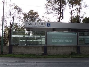
Las Torres light rail station
Distance: Approx. 1082 meters
Latitude and longitude: 19.340833,-99.143433
Las Torres light rail station is one of the stations on the Xochimilco Light Rail in Mexico City. Managed by the Servicio de Transportes Eléctricos, it is located between Tasqueña and Ciudad Jardín stations. It was inaugurated on August 1, 1986.

Ciudad Jardín light rail station
Railway station in Mexico City
Distance: Approx. 869 meters
Latitude and longitude: 19.335656,-99.141867
Ciudad Jardín light rail station is one of the stations on the Xochimilco Light Rail in Mexico City. Managed by the Servicio de Transportes Eléctricos, it is located between Las Torres and La Vírgen stations. It was inaugurated on August 1, 1986.

La Virgen light rail station
Railway station in Mexico City
Distance: Approx. 954 meters
Latitude and longitude: 19.331667,-99.140556
La Virgen light rail station is a station on the Xochimilco Light Rail in Mexico City. Managed by the Servicio de Transportes Eléctricos, it is located between Ciudad Jardín and Xotepingo stations. It was inaugurated on August 1, 1986.
Weather in this IP's area
broken clouds
21 Celsius
21 Celsius
21 Celsius
21 Celsius
1015 hPa
63 %
1015 hPa
789 hPa
9656 meters
0.45 m/s
1.34 m/s
109 degree
75 %
06:24:58
18:35:24