Country:
Region:
City:
Latitude and Longitude:
Time Zone:
Postal Code:
IP information under different IP Channel
ip-api
Country
Region
City
ASN
Time Zone
ISP
Blacklist
Proxy
Latitude
Longitude
Postal
Route
Luminati
Country
ASN
Time Zone
America/Argentina/Buenos_Aires
ISP
Telefonica Moviles Argentina S.A. Movistar Argentina
Latitude
Longitude
Postal
IPinfo
Country
Region
City
ASN
Time Zone
ISP
Blacklist
Proxy
Latitude
Longitude
Postal
Route
db-ip
Country
Region
City
ASN
Time Zone
ISP
Blacklist
Proxy
Latitude
Longitude
Postal
Route
ipdata
Country
Region
City
ASN
Time Zone
ISP
Blacklist
Proxy
Latitude
Longitude
Postal
Route
Popular places and events near this IP address

Flores, Buenos Aires
Neighborhood of Buenos Aires in C7, Argentina
Distance: Approx. 760 meters
Latitude and longitude: -34.63333333,-58.46666667
Flores (Spanish for “Flowers”) is a middle-class barrio or district in the center part of Buenos Aires city, Argentina. Flores was considered a rural area of the Province of Buenos Aires until 1888 when it was integrated into the city. Flores is the birthplace of Pope Francis.

Parque Chacabuco
Neighborhood of Buenos Aires in C7, Argentina
Distance: Approx. 1035 meters
Latitude and longitude: -34.63333333,-58.45
Parque Chacabuco is a neighbourhood in Buenos Aires, Argentina. Its name is due to Chacabuco Park, which is in its centre, taking the name from the Battle of Chacabuco.

Chacabuco Park
Distance: Approx. 1573 meters
Latitude and longitude: -34.63444444,-58.44333333
Chacabuco Park is a public park in the Parque Chacabuco section of Buenos Aires.
Carabobo (Buenos Aires Underground)
Buenos Aires Underground station
Distance: Approx. 1287 meters
Latitude and longitude: -34.62641667,-58.45608333
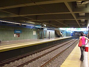
Carabobo is a station on Line A of the Buenos Aires Underground. It is located at the 6300 block of Rivadavia avenue. It is near the Koreatown of Buenos Aires.

San Pedrito (Buenos Aires Underground)
Buenos Aires Underground station
Distance: Approx. 1152 meters
Latitude and longitude: -34.63083333,-58.46972222
San Pedrito is a station on Line A of the Buenos Aires Underground and it is the current terminus of the line. The station was opened on 27 September 2013 as a part of the extension of the line from Carabobo.

San José de Flores (Buenos Aires Underground)
Buenos Aires Underground station
Distance: Approx. 1067 meters
Latitude and longitude: -34.62861111,-58.46444444
San José de Flores is a station on Line A of the Buenos Aires Underground. The station connects with Flores station on the Sarmiento Line commuter rail service. The station was opened on 27 September 2013 as part of the extension of the line from Carabobo to San Pedrito.

Plaza de los Virreyes - Eva Perón (Buenos Aires Underground)
Buenos Aires Underground station
Distance: Approx. 631 meters
Latitude and longitude: -34.64302778,-58.46161111
Plaza de los Virreyes - Eva Perón is a station on Line E of the Buenos Aires Underground and is the current terminus. The station was opened on 8 May 1986 as the western terminus of the one-line extension from Varela. It was originally called Plaza de los Virreyes; however, Eva Perón was added to the name of the station to commemorate Eva Duarte de Perón, the prominent Argentine historical figure.

Varela (Buenos Aires Underground)
Buenos Aires Underground station
Distance: Approx. 337 meters
Latitude and longitude: -34.64,-58.45802778
Varela is a station on Line E of the Buenos Aires Underground. The station was opened on 27 November 1985 as the western terminus of the one-line extension from Medalla Milagrosa. On 8 May 1986, the line was extended to Plaza de los Virreyes.

Medalla Milagrosa (Buenos Aires Underground)
Buenos Aires Underground station
Distance: Approx. 905 meters
Latitude and longitude: -34.63625,-58.45033333
Medalla Milagrosa is a station on Line E of the Buenos Aires Underground. It is located at the intersection of Eva Perón and Pumacahua avenues. The station was opened on 31 October 1985 as the western terminus of the one-line extension from Emilio Mitre.
Emilio Mitre (Buenos Aires Underground)
Buenos Aires Underground station
Distance: Approx. 1797 meters
Latitude and longitude: -34.631,-58.44213889
Emilio Mitre is a station on Line E of the Buenos Aires Underground. The station was opened on 7 October 1985 as a one station extension from José María Moreno. On 31 October 1985, the line was extended to Medalla Milagrosa.

2011 Flores rail crash
Railway accident in Buenos Aires, Argentina
Distance: Approx. 1200 meters
Latitude and longitude: -34.6275,-58.465
The 2011 Flores rail crash occurred at 06.23 ART on 13 September 2011 when a bus on a level crossing at Flores railway station, in the Flores barrio of Buenos Aires, Argentina, was hit by a train on the Sarmiento Line, heading for Moreno. The accident caused that same train to collide into another one as it derailed. It is regarded as the worst train accident in Buenos Aires within 50 years.

Instituto Coreano Argentino
Primary school in Buenos Aires, Argentina
Distance: Approx. 966 meters
Latitude and longitude: -34.639273,-58.449773
Instituto Coreano Argentino (ICA, "Argentina Korean School," Korean: 아르헨티나한국학교) is a Korean international school in Buenos Aires, Argentina. It serves the preschool and elementary school levels. In 2010 it had 29 teachers, 184 day kindergarten students, and 155 day elementary students.
Weather in this IP's area
clear sky
20 Celsius
20 Celsius
19 Celsius
22 Celsius
1011 hPa
69 %
1011 hPa
1008 hPa
10000 meters
5.81 m/s
360 degree
05:40:23
19:36:54

