Country:
 Venezuela
Region:
City:
Latitude and Longitude:
Time Zone:
Postal Code:
IP information under different IP Channel
ip-api
Country
Region
City
ASN
Time Zone
ISP
Blacklist
Proxy
Latitude
Longitude
Postal
Route
IPinfo
Country
Region
City
ASN
Time Zone
ISP
Blacklist
Proxy
Latitude
Longitude
Postal
Route
MaxMind
Country
Region
City
ASN
Time Zone
ISP
Blacklist
Proxy
Latitude
Longitude
Postal
Route
Luminati
Country
VEASN
Time Zone
America/Caracas
ISP
TELEFONICA VENEZOLANA, C.A.
Latitude
Longitude
Postal
db-ip
Country
Region
City
ASN
Time Zone
ISP
Blacklist
Proxy
Latitude
Longitude
Postal
Route
ipdata
Country
Region
City
ASN
Time Zone
ISP
Blacklist
Proxy
Latitude
Longitude
Postal
Route
Popular places and events near this IP address
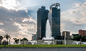
Caracas
Capital and largest city of Venezuela
Distance: Approx. 5 meters
Latitude and longitude: 10.48055556,-66.90361111
Caracas ( kə-RA(H)K-əs, Spanish: [kaˈɾakas]), officially Santiago de León de Caracas (CCS), is the capital and largest city of Venezuela, and the center of the Metropolitan Region of Caracas (or Greater Caracas). Caracas is located along the Guaire River in the northern part of the country, within the Caracas Valley of the Venezuelan coastal mountain range (Cordillera de la Costa). The valley is close to the Caribbean Sea, separated from the coast by a steep 2,200-meter-high (7,200 ft) mountain range, Cerro El Ávila; to the south there are more hills and mountains.

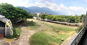
Central University of Venezuela
Venezuelan public university
Distance: Approx. 1658 meters
Latitude and longitude: 10.4884,-66.8907
The Central University of Venezuela (Spanish: Universidad Central de Venezuela; UCV) is a public university located in Caracas, Venezuela. Founded in 1721, it is the oldest university in Venezuela and one of the oldest in the Western Hemisphere. The main university campus, Ciudad Universitaria de Caracas, was designed by architect Carlos Raúl Villanueva and it is considered a masterpiece of urban planning and was declared a World Heritage Site by UNESCO in 2000.

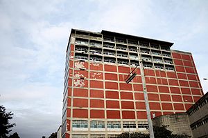
Hospital Clínico Universitario
Hospital in Caracas, Venezuela
Distance: Approx. 1513 meters
Latitude and longitude: 10.49027778,-66.89388889
The Hospital Universitario de Caracas or University Hospital of Caracas (also named Hospital Clínico Universitario or just El Clínico) is a publicly owned hospital located in the spaces of the Ciudad Universitaria de Caracas, part of the Central University of Venezuela, located in the Chaguaramos parish of Libertador Municipality in the District Capital of Venezuela and west of Caracas Metropolitan District and the city of Caracas, the north central Venezuela. The idea of creating this institution arose in the year 1943 on the initiative of General Eleazar López Contreras who in the same year ordered start work with the design of the architect Carlos Raúl Villanueva. It was completed in 1954 and opened in the year 1956 under the dictatorship of General Marcos Perez Jimenez .

Attack on Richard Nixon's motorcade
1958 attack on the motorcade of US Vice President
Distance: Approx. 5 meters
Latitude and longitude: 10.48055556,-66.90361111
On May 13, 1958, US Vice President Richard Nixon's motorcade was attacked by a mob in Caracas, Venezuela, during Nixon's goodwill tour of South America. The event was described at the time as the "most violent attack ever perpetrated on a high American official while on foreign soil." Close to being killed while a couple of his aides were injured in the melee, Nixon ended up unharmed and his entourage managed to reach the U.S. embassy. The visit took place only months after the overthrow in January of Venezuelan dictator Marcos Pérez Jiménez, who in 1954 had been awarded the Legion of Merit and was later granted asylum by the United States, and the incident may have been orchestrated by the Communist Party of Venezuela.

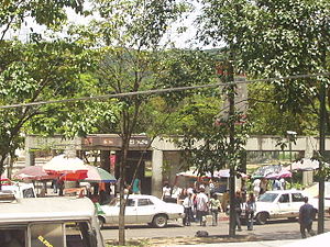
El Valle Parish
Parish in Distrito Capital, Venezuela
Distance: Approx. 1541 meters
Latitude and longitude: 10.46722222,-66.90722222
El Valle is one of the 22 parishes located in the Libertador Bolivarian Municipality and one of 32 of Caracas, Venezuela.
Tierra de nadie (Central University of Venezuela)
UNESCO World Heritage Site in University City of Caracas, Venezuela
Distance: Approx. 1818 meters
Latitude and longitude: 10.49038889,-66.89030556
Tierra de nadie (No man's land) is the unofficial name of a public green space officially called Plaza Jorge Rodríguez in the University City of Caracas, the campus of the Central University of Venezuela.
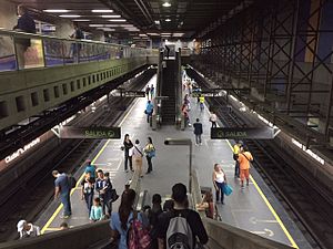
Ciudad Universitaria station (Caracas)
Caracas metro station
Distance: Approx. 1785 meters
Latitude and longitude: 10.48805556,-66.88916667
Ciudad Universitaria is a Caracas Metro station on Line 3. It was opened on 18 December 1994 as part of the inaugural section of Line 3 from Plaza Venezuela to El Valle. The station is between Plaza Venezuela and Los Símbolos.
Central Library (Central University of Venezuela)
UNESCO World Heritage Site in University City of Caracas, Venezuela
Distance: Approx. 1748 meters
Latitude and longitude: 10.48991667,-66.89075
The Biblioteca Central de la UCV, or Central Library is the main library in the University City of Caracas, and the most important one of the Central University of Venezuela. It is easily accessible from anywhere in the city as it is near the Caracas Metro line 3 station Ciudad Universitaria.

Los Símbolos station
Caracas metro station
Distance: Approx. 834 meters
Latitude and longitude: 10.48275,-66.89630556
Los Símbolos is a Caracas Metro station on Line 3. It was opened on 18 December 1994 as part of the inaugural section of Line 3 from Plaza Venezuela to El Valle. The station is between Ciudad Universitaria and La Bandera.
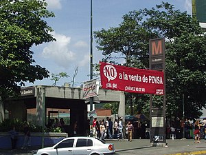
La Bandera station
Caracas metro station
Distance: Approx. 313 meters
Latitude and longitude: 10.47869444,-66.9015
La Bandera is a Caracas Metro station on Line 3. It was opened on 18 December 1994 as part of the inaugural section of Line 3 from Plaza Venezuela to El Valle. The station is between Los Símbolos and El Valle.
El Valle station
Caracas metro station
Distance: Approx. 1330 meters
Latitude and longitude: 10.46869444,-66.90458333
El Valle is a Caracas Metro station on Line 3. It was opened on 18 December 1994 as the southern terminus of the inaugural section of Line 3 from Plaza Venezuela to El Valle. The station is between La Bandera and Los Jardines.

Berger des Nuages
Distance: Approx. 1787 meters
Latitude and longitude: 10.49094444,-66.89111111
Berger des Nuages, Pastor de Nubes, or Cloud Shepherd is a work of art by Jean Arp just outside the Plaza Cubierta of the University City of Caracas.
Weather in this IP's area
scattered clouds
24 Celsius
25 Celsius
21 Celsius
24 Celsius
1015 hPa
80 %
1015 hPa
916 hPa
10000 meters
1.54 m/s
330 degree
40 %
06:16:02
18:14:52