200.58.244.60 - IP Lookup: Free IP Address Lookup, Postal Code Lookup, IP Location Lookup, IP ASN, Public IP
Country:
Region:
City:
Location:
Time Zone:
Postal Code:
IP information under different IP Channel
ip-api
Country
Region
City
ASN
Time Zone
ISP
Blacklist
Proxy
Latitude
Longitude
Postal
Route
Luminati
Country
Region
06
City
sanfranciscodemacoris
ASN
Time Zone
America/Santo_Domingo
ISP
Cable Atlantico SRL
Latitude
Longitude
Postal
IPinfo
Country
Region
City
ASN
Time Zone
ISP
Blacklist
Proxy
Latitude
Longitude
Postal
Route
IP2Location
200.58.244.60Country
Region
santiago
City
santiago de los caballeros
Time Zone
America/Santo_Domingo
ISP
Language
User-Agent
Latitude
Longitude
Postal
db-ip
Country
Region
City
ASN
Time Zone
ISP
Blacklist
Proxy
Latitude
Longitude
Postal
Route
ipdata
Country
Region
City
ASN
Time Zone
ISP
Blacklist
Proxy
Latitude
Longitude
Postal
Route
Popular places and events near this IP address

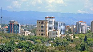
Santiago de los Caballeros
City in Santiago, Dominican Republic
Distance: Approx. 1434 meters
Latitude and longitude: 19.45722222,-70.68888889
Santiago de los Caballeros (English: Saint James of the Knights), often shortened to Santiago, is the second-largest city in the Dominican Republic and the fourth-largest city in the Caribbean by population. It is the capital of Santiago Province and the largest major metropolis in the Cibao region of the country. Santiago is the largest Caribbean city that is not a capital city, and it is also the largest non-coastal metropolis in the Caribbean islands.
Gurabo, Dominican Republic
Place in Santiago, Dominican Republic
Distance: Approx. 3928 meters
Latitude and longitude: 19.47388,-70.67265
Gurabo is a suburban section in northeast Santiago de los Caballeros, Dominican Republic. Its estimated population is 42,000. Gurabo is best known for its tobacco plantations and amber mines.
Estadio La Barranquita
Stadium in Dominican Republic
Distance: Approx. 4765 meters
Latitude and longitude: 19.42005833,-70.73263333
Estadio La Barranquita is a multi-use stadium in Santiago, Dominican Republic. It is currently used mostly for football matches. The stadium holds 20,000.

Estadio Cibao
Distance: Approx. 2095 meters
Latitude and longitude: 19.46694444,-70.70888889
Estadio Cibao is a multi-use stadium in Santiago, Dominican Republic. Currently, it is mostly used for baseball games and hosts the home games of the Águilas Cibaeñas in the Dominican Winter Baseball League. The stadium opened on October 25, 1958 and was constructed by the engineer Bienvenido Martinez Brea.

Roman Catholic Archdiocese of Santiago de los Caballeros
Roman Catholic archdiocese in the Dominican Republic
Distance: Approx. 679 meters
Latitude and longitude: 19.45027778,-70.70666667
The Roman Catholic Metropolitan Archdiocese of Santiago de los Caballeros (Latin: Archidioecesis Metropolitae Sancti Iacobi Equitum) is a Latin Rite Metropolitan Archdiocese in the Dominican Republic.
Monumento de Santiago
Distance: Approx. 550 meters
Latitude and longitude: 19.4506,-70.695
The Monumento a los Héroes de la Restauración (Monument to the Heroes of the Restoration) is a monument in the city of Santiago de los Caballeros in the Dominican Republic. It is the highest building in Santiago, and a major tourist attraction for the area. The monument is located on a hill in the middle of Santiago, with views of the city and surrounding mountains.

Hospital Metropolitano de Santiago
Hospital in Santiago Province, Dominican Republic
Distance: Approx. 4369 meters
Latitude and longitude: 19.436414,-70.661153
The Hospital Metropolitano de Santiago (HOMS) is the largest hospital in the Dominican Republic and one of the most modern hospitals in Latin America and the Caribbean, with 300 doctor's offices, 400 beds, 16 operating rooms, a hotel, and other specialized units. HOMS not only takes care of the Dominicans’ health but also allows foreigners to have the opportunity to receive high quality health care at low prices in what is called "health tourism". HOMS has an investment of more than $80.0 million US dollars.

Gran Arena del Cibao
Arena in the Dominican Republic
Distance: Approx. 1978 meters
Latitude and longitude: 19.4654,-70.7096
The Gran Arena del Cibao Dr. Oscar Gobaira, formerly known as the Palacio de los Deportes, is a multi-purpose arena in Santiago de los Caballeros, Dominican Republic, built in 1978. The arena has a capacity of 8,768 seats, consisting of 7,000 regular seats, 668 comfortable armchairs and 1,100 luxury seats that are fully reclinable.

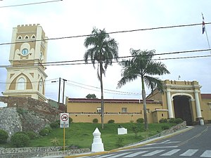
Fortaleza San Luis
History museum in Santiago, Dominican Republic
Distance: Approx. 337 meters
Latitude and longitude: 19.44824683,-70.70281944
Fortaleza San Luis is located near the Yaque del Norte River in southwest Santiago de los Caballeros, Dominican Republic. The Fort was the location of several battles during the War of Restoration. Fortaleza San Luis has also served as a Municipal Prison and more recently the fort has been converted into a Museum.
Nivaje Shale
Distance: Approx. 5566 meters
Latitude and longitude: 19.5,-70.7
The Nivaje Shale is a geologic group in Dominican Republic. It preserves coral fossils dating back to the Miocene period.

Estadio Cibao FC
Football statdium in the Dominican Republic
Distance: Approx. 2213 meters
Latitude and longitude: 19.44550278,-70.67966389
Cibao FC Stadium is a football stadium in Santiago de los Caballeros, Dominican Republic. It is currently used for football matches and hosts the home games of Cibao FC of the Liga Dominicana de Fútbol. The stadium holds 8,000 spectators.
St. James the Apostle Cathedral, Santiago de los Caballeros
Church in Santiago de los Caballeros, Dominican Republic
Distance: Approx. 683 meters
Latitude and longitude: 19.45023,-70.7067
The St. James the Apostle Cathedral (also Santiago de los Caballeros Cathedral; Spanish: Catedral de Santiago Apóstol) is a Catholic church located in the city of Santiago de los Caballeros, the capital of Santiago Province in the Dominican Republic. It was baptized thus in honor of St.
Weather in this IP's area
fog
21 Celsius
21 Celsius
20 Celsius
21 Celsius
1016 hPa
100 %
1016 hPa
992 hPa
500 meters
1.54 m/s
75 %

