200.56.117.236 - IP Lookup: Free IP Address Lookup, Postal Code Lookup, IP Location Lookup, IP ASN, Public IP
Country:
 Mexico
Region:
City:
Location:
Time Zone:
Postal Code:
ISP:
ASN:
language:
User-Agent:
Proxy IP:
Blacklist:
IP information under different IP Channel
ip-api
Country
Region
City
ASN
Time Zone
ISP
Blacklist
Proxy
Latitude
Longitude
Postal
Route
db-ip
Country
Region
City
ASN
Time Zone
ISP
Blacklist
Proxy
Latitude
Longitude
Postal
Route
IPinfo
Country
Region
City
ASN
Time Zone
ISP
Blacklist
Proxy
Latitude
Longitude
Postal
Route
IP2Location
200.56.117.236Country
mxRegion
aguascalientes
City
jesus maria
Time Zone
America/Mexico_City
ISP
Language
User-Agent
Latitude
Longitude
Postal
ipdata
Country
Region
City
ASN
Time Zone
ISP
Blacklist
Proxy
Latitude
Longitude
Postal
Route
Popular places and events near this IP address

Jesús María, Aguascalientes
City in the Mexican state of Aguascalientes
Distance: Approx. 929 meters
Latitude and longitude: 21.96666667,-102.35
Jesús María is a city in the Mexican state of Aguascalientes. It stands at 21°58′N 102°21′W and serves as the municipal seat of the surrounding municipality of Jesús María. As of 2010, the city of Jesús María had a population of 43,012, making it the second largest city in the state.
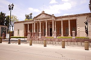
Aguascalientes Museum
Museum in Aguascalientes, México
Distance: Approx. 9950 meters
Latitude and longitude: 21.885881,-102.291245
The Aguascalientes City Museum (Spanish: Museo de Aguascalientes) is the premier art museum in the city of Aguascalientes in the state of Aguascalientes, Mexico.

Aguascalientes Municipality
Municipality in the Mexican state of Aguascalientes
Distance: Approx. 9744 meters
Latitude and longitude: 21.88333333,-102.3
Aguascalientes is a municipality in the Mexican state of Aguascalientes. Its municipal seat is the city of Aguascalientes, which is also the state capital. As of 2010, its population was 797,010, most of whom lived in the city of Aguascalientes.

Autonomous University of Aguascalientes
University in Mexico
Distance: Approx. 6062 meters
Latitude and longitude: 21.91338056,-102.315025
The Autonomous University of Aguascalientes (in Spanish: Universidad Autónoma de Aguascalientes, UAA) is a Mexican public university based in the city of Aguascalientes, Mexico. The Autonomous University of Aguascalientes has several campuses that are located across the state. The university was founded on June 19, 1973, its preceding institution, The School of Agriculture (in Spanish: Escuela de Agricultura), was founded on January 15, 1867.

1st federal electoral district of Aguascalientes
Federal electoral district of Mexico
Distance: Approx. 929 meters
Latitude and longitude: 21.96666667,-102.35
The 1st federal electoral district of Aguascalientes (Distrito electoral federal 01 de Aguascalientes) is one of the 300 electoral districts into which Mexico is divided for elections to the federal Chamber of Deputies and one of three such districts in the state of Aguascalientes. It elects one deputy to the lower house of Congress for each three-year legislative session by means of the first-past-the-post system. Votes cast in the district also count towards the calculation of proportional representation ("plurinominal") deputies elected from the second region.
2nd federal electoral district of Aguascalientes
Federal electoral district of Mexico
Distance: Approx. 9744 meters
Latitude and longitude: 21.88333333,-102.3
The 2nd federal electoral district of Aguascalientes (Distrito electoral federal 02 de Aguascalientes) is one of the 300 electoral districts into which Mexico is divided for elections to the federal Chamber of Deputies and one of three such districts in the state of Aguascalientes. It elects one deputy to the lower house of Congress for each three-year legislative session by means of the first-past-the-post system. Votes cast in the district also count towards the calculation of proportional representation ("plurinominal") deputies elected from the second region.
3rd federal electoral district of Aguascalientes
Federal electoral district of Mexico
Distance: Approx. 9744 meters
Latitude and longitude: 21.88333333,-102.3
The 3rd federal electoral district of Aguascalientes (Distrito electoral federal 03 de Aguascalientes) is one of the 300 electoral districts into which Mexico is divided for elections to the federal Chamber of Deputies and one of three such districts in the state of Aguascalientes. It elects one deputy to the lower house of Congress for each three-year legislative session by means of the first-past-the-post system. Votes cast in the district also count towards the calculation of proportional representation ("plurinominal") deputies elected from the second region.

Jesús María Municipality
Municipality in the Mexican state of Aguascalientes
Distance: Approx. 929 meters
Latitude and longitude: 21.96666667,-102.35
Jesús María is a municipality in the Mexican state of Aguascalientes. It stands at 21°58′N 102°21′W. As of 2010, the municipality had a total population of 99,590.

Jesús María (El Zapote)
Town in San Martín de Hidalgo, Mexico
Distance: Approx. 231 meters
Latitude and longitude: 21.963,-102.3442
Jesús María, also known as El Zapote, is a town in the municipality of San Martín de Hidalgo in the state of Jalisco, Mexico. It has a population of 278 inhabitants.

Aguascalientes Territory
Mexican federal territory (1835–1857)
Distance: Approx. 6224 meters
Latitude and longitude: 22.016667,-102.35
Aguascalientes was a federal territory of Mexico, lasting from 1835 and 1857.
Pocitos, Aguascalientes
Locality in Aguascalientes, Mexico
Distance: Approx. 5757 meters
Latitude and longitude: 21.91193889,-102.326
Pocitos is an inhabited place in the state of Aguascalientes. It is located 3 miles northwest of the city of Aguascalientes and has a population of 5,169.

Jardín de San Marcos
Garden in the historic centre of Aguascalientes, Mexico
Distance: Approx. 9974 meters
Latitude and longitude: 21.879576,-102.30324
The Jardín de San Marcos (English: San Marcos Garden; St. Mark Garden) is a public garden located in the Barrio de San Marcos in the historic centre of Aguascalientes, Aguascalientes, Mexico, Has a various types of plant and tree species. It has paths throughout the garden which have on their sides the iconic bronze statues representatives of the regional culture.
Weather in this IP's area
clear sky
11 Celsius
9 Celsius
11 Celsius
11 Celsius
1017 hPa
48 %
1017 hPa
800 hPa
10000 meters
2.09 m/s
1.79 m/s
325 degree