Country:
 Mexico
Region:
City:
Latitude and Longitude:
Time Zone:
Postal Code:
IP information under different IP Channel
ip-api
Country
Region
City
ASN
Time Zone
ISP
Blacklist
Proxy
Latitude
Longitude
Postal
Route
IPinfo
Country
Region
City
ASN
Time Zone
ISP
Blacklist
Proxy
Latitude
Longitude
Postal
Route
MaxMind
Country
Region
City
ASN
Time Zone
ISP
Blacklist
Proxy
Latitude
Longitude
Postal
Route
Luminati
Country
MXRegion
cmx
City
mexicocity
ASN
Time Zone
America/Mexico_City
ISP
Megacable Comunicaciones de Mexico, S.A. de C.V.
Latitude
Longitude
Postal
db-ip
Country
Region
City
ASN
Time Zone
ISP
Blacklist
Proxy
Latitude
Longitude
Postal
Route
ipdata
Country
Region
City
ASN
Time Zone
ISP
Blacklist
Proxy
Latitude
Longitude
Postal
Route
Popular places and events near this IP address
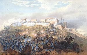
Battle of Chapultepec
Battle of the Mexican–American War
Distance: Approx. 443 meters
Latitude and longitude: 19.421,-99.182
The Battle of Chapultepec took place between U.S. forces and Mexican soldiers holding the strategically located Chapultepec Castle just outside Mexico City on the 13th of September, 1847 during the Mexican–American War. The castle was built atop a 200-foot (61 m) hill, and was used as a military academy. The battle was part of the campaign to sieze Mexico City, for which General Winfield Scott's U.S. Army totaled 7,200 men.

Battle of Molino del Rey
Distance: Approx. 624 meters
Latitude and longitude: 19.419,-99.191
The Battle of Molino del Rey (8 September 1847) was one of the bloodiest engagements of the Mexican–American War as part of the Battle for Mexico City. It was fought in September 1847 between Mexican forces under General Antonio León against an American force under Major General Winfield Scott at El Molino del Rey on the fringes of Mexico City. The Americans made little progress in this battle, but the Mexican forces were unable to hold them back long enough to prevent the capture of Mexico City one week later.

Chapultepec Castle
Castle in Mexico City
Distance: Approx. 439 meters
Latitude and longitude: 19.42055556,-99.18166667
Chapultepec Castle (Spanish: Castillo de Chapultepec) is located on top of Chapultepec Hill in Mexico City's Chapultepec park. The name Chapultepec is the Nahuatl word chapoltepēc which means "on the hill of the grasshopper". It is located at the entrance to Chapultepec park, at a height of 2,325 metres (7,628 ft) above sea level.

Museo Nacional de Historia
History museum in Mexico City, Mexico
Distance: Approx. 452 meters
Latitude and longitude: 19.4206,-99.18155556
The National Museum of History (Spanish: Museo Nacional de Historia), also known as MNH, is a national museum of Mexico, located inside Chapultepec Castle in Mexico City. The Castle itself is found within the first section of the well known Chapultepec Park. The museum received 2,135,465 visitors in 2017.
Galería de Arte Mexicano
Distance: Approx. 615 meters
Latitude and longitude: 19.41305556,-99.18694444
The Galería de Arte Mexicano (GAM) was founded by Carolina in 1935 and directed by Inés Amor, her sister from 1936 until the 80's, in Mexico City and has been the first gallery of Mexican art. The gallery building was the first building in Mexico of Andrés Casillas de Alba. The intention of the GAM is to establish national artists as well as the promotion of young artists.

Casa del Lago Juan José Arreola
Cultural center in Mexico
Distance: Approx. 506 meters
Latitude and longitude: 19.422655,-99.186494
Casa del Lago was instituted in 1959 as the first off-campus Cultural Center of the National Autonomous University of Mexico. It is characterized by its extraordinary ability to promote the cultural and generational encounter between the vanguard and tradition. It was established with Juan José Arreola as its founding director and is located in the Woods of Chapultepec, a traditional Sunday walk area for the inhabitants of the capital.

Museo del Caracol
Mexican history museum in Mexico City
Distance: Approx. 203 meters
Latitude and longitude: 19.418956,-99.183298
The Museo del Caracol (lit. Snail Museum) is a Mexican history museum, at the bottom of the access ramp to the Castillo de Chapultepec in Mexico City. The “Snail Museum” is a spiral shaped building designed by the architect Pedro Ramirez Vazquez.

Obelisco a los Niños Héroes
Monument in Chapultepec, Mexico City
Distance: Approx. 555 meters
Latitude and longitude: 19.42046,-99.18034
The Obelisco a los Niños Héroes is a monument installed in Chapultepec, Mexico City. The cenotaph was created in 1881 by architect Ramón Rodríguez Arangoity, one of the cadets captured in the Battle of Chapultepec. The marble cenotaph was a typical nineteenth-century monument.

El Sargento
Tree in Chapultepec, Mexico City
Distance: Approx. 462 meters
Latitude and longitude: 19.41933333,-99.18083333
El Sargento is a Mexican cypress tree in Mexico City's park Chapultepec, planted by Nezahualcoyotl c. 1460. After living for approximately 500 years, the tree died in 1969, and its trunk stands today at around 50 feet tall.

Tribuna Monumental
Monument in Chapultepec, Mexico City
Distance: Approx. 438 meters
Latitude and longitude: 19.41944444,-99.18111111
Tribuna Monumental, or the Monumento a las Águilas Caídas, is a monument in Chapultepec, Mexico City, commemorating Mexican army officers in Squadron 201, who fought on the Pacific front during World War II.
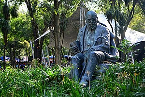
Statue of León Felipe, Mexico City
Statue in Mexico City, Mexico
Distance: Approx. 457 meters
Latitude and longitude: 19.42227778,-99.18619444
The statue of León Felipe is installed in Mexico City's Chapultepec park, in Mexico. The statue was created by Julián Martinez in 1973, and dedicated in 1974.

Templanza Fountain
Fountain in Chapultepec, Mexico City, Mexico
Distance: Approx. 490 meters
Latitude and longitude: 19.41930556,-99.18055556
Templanza Fountain (Spanish: Fuente de la Templanza) is a fountain in Chapultepec, Mexico City, Mexico.
Weather in this IP's area
scattered clouds
22 Celsius
22 Celsius
22 Celsius
23 Celsius
1014 hPa
43 %
1014 hPa
787 hPa
8047 meters
2.06 m/s
100 degree
40 %
06:32:06
18:11:07