Country:
Region:
City:
Latitude and Longitude:
Time Zone:
Postal Code:
IP information under different IP Channel
ip-api
Country
Region
City
ASN
Time Zone
ISP
Blacklist
Proxy
Latitude
Longitude
Postal
Route
Luminati
Country
ASN
Time Zone
America/Argentina/Buenos_Aires
ISP
Telefonica Moviles Argentina S.A. Movistar Argentina
Latitude
Longitude
Postal
IPinfo
Country
Region
City
ASN
Time Zone
ISP
Blacklist
Proxy
Latitude
Longitude
Postal
Route
db-ip
Country
Region
City
ASN
Time Zone
ISP
Blacklist
Proxy
Latitude
Longitude
Postal
Route
ipdata
Country
Region
City
ASN
Time Zone
ISP
Blacklist
Proxy
Latitude
Longitude
Postal
Route
Popular places and events near this IP address

National University of Rosario
Research public university in Rosario, Santa Fe, Argentina
Distance: Approx. 482 meters
Latitude and longitude: -32.94277778,-60.65
The National University of Rosario (Spanish: Universidad Nacional de Rosario, UNR) is a research public university located in the city of Rosario, province of Santa Fe, Argentina.

Dr. Ángel Gallardo Provincial Natural Sciences Museum
Public museum in Rosario, Argentina
Distance: Approx. 482 meters
Latitude and longitude: -32.94277778,-60.65
The Dr. Ángel Gallardo Provincial Natural Sciences Museum (in Spanish, Museo Provincial de Ciencias Naturales Dr. Ángel Gallardo) is a public museum in Rosario, Argentina, specialized in biology.

San Martín Street (Rosario)
Street in Rosaria, Argentina
Distance: Approx. 846 meters
Latitude and longitude: -32.9467,-60.6367
San Martín Street is an important street in Rosario, Santa Fe Province, Argentina. It runs north–south through the center of the city, from the coastal avenue by the Paraná River to the southern limit of the urbanized area (a total of 6.5 km). It was originally named Calle del Puerto ("Port Street"); the name was changed in 1887 to honour Independence War hero General José de San Martín.

Rosario Central railway station
Former railway station in Rosario, Argentina
Distance: Approx. 987 meters
Latitude and longitude: -32.93717222,-60.64031944
Rosario Central is a former railway station in Rosario, Argentina. It is located at the junction of Corrientes St. and Wheelwright Avenue, in the city center, not far from the coast of the Paraná River.

Plaza San Martín (Rosario)
Distance: Approx. 414 meters
Latitude and longitude: -32.943645,-60.649676
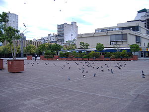
Plaza San Martín (Spanish, San Martín Square) is a plaza (urban square) in Rosario, province of Santa Fe, Argentina. Its name is an homage to General José de San Martín, hero of the Argentine War of Independence. Plaza San Martín is located in the downtown area of Rosario, occupying the block defined by Santa Fe St., Dorrego St., Córdoba St.

Plaza Pringles (Rosario)
Square in the city of Rosario, Argentina
Distance: Approx. 107 meters
Latitude and longitude: -32.945121,-60.644386
Plaza Pringles (Spanish for "Pringles Square") is a plaza (urban square) in Rosario, province of Santa Fe, Argentina. Its name is an homage to Colonel Juan Pascual Pringles, hero of the Spanish American wars of independence (who also gave its name to the Plaza Pringles located in the city of San Luis). Plaza Pringles occupies a half block in the downtown area of Rosario, beside the historical section of Córdoba St.

Plaza Sarmiento (Rosario)
Plaza in city of Rosario, Santa Fe, Argentina
Distance: Approx. 579 meters
Latitude and longitude: -32.94947,-60.642541
Plaza Sarmiento is a plaza (urban square) in the city of Rosario, province of Santa Fe, Argentina. Its name is an homage to former Argentine president Domingo Faustino Sarmiento. Plaza Sarmiento is located in a strategic location within the Rosario downtown area, and serves as a transport node for many urban and short-distance interurban bus lines.

Plaza Montenegro (Rosario)
Distance: Approx. 883 meters
Latitude and longitude: -32.949479,-60.637777
Plaza Santiago Montenegro is a small hardscape plaza in the city of Rosario, province of Santa Fe, Argentina. Its name honors one of the first Spanish-descended settlers in the area, Captain Santiago Montenegro. It was known as Plaza Pinasco until 1993.
Facultad de Derecho (UNR)
Distance: Approx. 536 meters
Latitude and longitude: -32.94388889,-60.65111111
The Facultad de Derecho is the Law School of the National University of Rosario (Argentina), and is located in the former Palace of Justice Building, a Rosario landmark and a National Historic Monument.

Palacio Cabanellas
Distance: Approx. 783 meters
Latitude and longitude: -32.949245,-60.638904
The Palacio Cabanellas (Spanish, Cabanellas Palace) is a historical building in the city of Rosario, province of Santa Fe, Argentina. It is located in the downtown area, occupying the southwestern corner of San Luis St. and Sarmiento St.

Palacio Minetti
Distance: Approx. 250 meters
Latitude and longitude: -32.945481,-60.642917
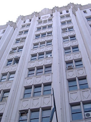
The Palacio Minetti (Spanish, Minetti Palace) is a building in Rosario, in Santa Fe Province, Argentina. It is located at one end of the pedestrian segment of Córdoba St., within the historical district known as Paseo del Siglo. The palace was projected in 1929 by the architects José Gerbino, Luis Schwarz and Juan Bautista Durand, who were commissioned by Domingo Minetti, a vegetable oil and mill industry businessman, for the design of new corporate headquarters for Minetti y Compañía.

Palace of Justice (Rosario)
Former courthouse in Rosario, Santa Fe, Argentina
Distance: Approx. 536 meters
Latitude and longitude: -32.94388889,-60.65111111
The Palace of Justice (Palacio de Justicia) is a former courthouse in Rosario, Santa Fe, Argentina. Juan Canals, an entrepreneur, commissioned the British architect Herbert Boyd Walker, who conceived and built the Palace of Justice in 1892. The building constitutes a singular example of the eclectic style common at the end of the century.
Weather in this IP's area
clear sky
28 Celsius
28 Celsius
28 Celsius
28 Celsius
1009 hPa
44 %
1009 hPa
1005 hPa
10000 meters
7.72 m/s
10 degree
05:52:37
19:42:09