Country:
 Venezuela
Region:
City:
Latitude and Longitude:
Time Zone:
Postal Code:
IP information under different IP Channel
ip-api
Country
Region
City
ASN
Time Zone
ISP
Blacklist
Proxy
Latitude
Longitude
Postal
Route
IPinfo
Country
Region
City
ASN
Time Zone
ISP
Blacklist
Proxy
Latitude
Longitude
Postal
Route
MaxMind
Country
Region
City
ASN
Time Zone
ISP
Blacklist
Proxy
Latitude
Longitude
Postal
Route
Luminati
Country
VEASN
Time Zone
America/Caracas
ISP
TELEFONICA VENEZOLANA, C.A.
Latitude
Longitude
Postal
db-ip
Country
Region
City
ASN
Time Zone
ISP
Blacklist
Proxy
Latitude
Longitude
Postal
Route
ipdata
Country
Region
City
ASN
Time Zone
ISP
Blacklist
Proxy
Latitude
Longitude
Postal
Route
Popular places and events near this IP address

Bolívar (state)
State in Venezuela
Distance: Approx. 3768 meters
Latitude and longitude: 8.12194444,-63.55
Bolívar (Spanish: Estado Bolívar, IPA: [esˈtaðo βoˈliβaɾ]) is one of the 23 states of Venezuela. The state capital city is Ciudad Bolívar and the largest city is Ciudad Guayana. Bolívar State covers a total surface area of 242,801 km2 (93,746 sq mi) and as of the 2011 census, had a population of 1,410,964.
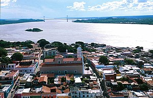
Ciudad Bolívar
City in Bolívar, Venezuela
Distance: Approx. 5558 meters
Latitude and longitude: 8.13793,-63.548266
Ciudad Bolívar (Spanish pronunciation: [sjuˈðað βoˈliβaɾ]; Spanish for "Bolivar City"), formerly known as Angostura and St. Thomas de Guyana, is the capital of Venezuela's southeastern Bolívar State. It lies at the spot where the Orinoco River narrows to about 1 mile (1.6 km) in width, is the site of the first bridge across the river, and is a major riverport for the eastern regions of Venezuela.

Angostura Bridge
Bridge near Ciudad Bolívar, Venezuela
Distance: Approx. 7943 meters
Latitude and longitude: 8.14444444,-63.59805556
Angostura Bridge is a suspension bridge that spans the Orinoco River at Ciudad Bolívar, Venezuela. The Spanish word Angostura means "narrows". Built in 1967 at a cost of US$35million, the bridge has a total length of 1,678.50 meters, a distance of 1,272 meters between the two towers, and a main span of 712 meters.

Jesús Soto Museum of Modern Art
Museum of modern art in Ciudad Bolívar, Venezuela
Distance: Approx. 5254 meters
Latitude and longitude: 8.1325,-63.53694444
The Jesús Soto Museum of Modern Art (Spanish: Museo de Arte Moderno Jesús Soto) is a museum of modern art in Ciudad Bolívar, Venezuela. It is named after the kinetic artist and sculptor Jesús Rafael Soto, who was born in Ciudad Bolívar. The museum, which opened in 1973, is a late work of the Venezuelan modernist architect Carlos Raúl Villanueva.

Roman Catholic Archdiocese of Ciudad Bolívar
Roman Catholic archdiocese in Venezuela
Distance: Approx. 6163 meters
Latitude and longitude: 8.1436,-63.5513
The Roman Catholic Archdiocese of Ciudad Bolívar (Latin: Civitatis Bolivaren(sis)) is an archdiocese located in the city of Ciudad Bolívar in Venezuela.

Tomás de Heres Airport
Airport in Venezuela
Distance: Approx. 4242 meters
Latitude and longitude: 8.12222222,-63.53611111
Tomás de Heres Airport (Spanish: Aeropuerto Nacional Tomas de Heres, (IATA: CBL, ICAO: SVCB)) is an airport serving Ciudad Bolívar, the capital of the Bolívar state of Venezuela. The airport is named in honor of Tomás de Heres, a hero of Latin American independence and governor of Venezuela's former Guayana Province. The airport serves as a maintenance base for RUTACA Airlines.

Orinoco Department
Place
Distance: Approx. 4108 meters
Latitude and longitude: 8.08333333,-63.51666667
Orinoco Department was one of the departments of Gran Colombia created in 1824. Its territory was split from the Venezuela Department. It had borders to Apure Department in the West.

St. Thomas Cathedral, Ciudad Bolívar
Church in Ciudad Bolívar, Venezuela
Distance: Approx. 6187 meters
Latitude and longitude: 8.1438,-63.5511
The Cathedral of St. Thomas (Spanish: Catedral de Santo Tomás de Ciudad Bolívar), also called Ciudad Bolívar Cathedral, is the cathedral of the Roman Catholic Archdiocese of Ciudad Bolívar. It is located opposite Bolívar Square in Ciudad Bolívar, capital of Bolívar State in the Guayana region in southern Venezuela.
First Battle of Angostura
1817 battle in the Venezuelan War of Independence
Distance: Approx. 5569 meters
Latitude and longitude: 8.138,-63.548
The First Battle of Angostura took place during the Venezuelan War of Independence. The battle saw Patriot forces attempt to capture the city of Angostura, but retreat after being unable to penetrate Spanish defenses.

Second Battle of Angostura
1817 battle in the Venezuelan War of Independence
Distance: Approx. 5558 meters
Latitude and longitude: 8.13793,-63.548266
The Second Battle of Angostura was a military siege and confrontation that took place in the context of the Venezuelan War of Independence between Patriot and Royalist forces, that ended with victory for the Patriots, who managed to capture the city of Angostura on 17 July 1817.
Weather in this IP's area
overcast clouds
30 Celsius
33 Celsius
30 Celsius
30 Celsius
1014 hPa
61 %
1014 hPa
1003 hPa
10000 meters
2.24 m/s
2.59 m/s
221 degree
89 %
06:01:44
18:02:22