Country:
 Venezuela
Region:
City:
Latitude and Longitude:
Time Zone:
Postal Code:
IP information under different IP Channel
ip-api
Country
Region
City
ASN
Time Zone
ISP
Blacklist
Proxy
Latitude
Longitude
Postal
Route
IPinfo
Country
Region
City
ASN
Time Zone
ISP
Blacklist
Proxy
Latitude
Longitude
Postal
Route
MaxMind
Country
Region
City
ASN
Time Zone
ISP
Blacklist
Proxy
Latitude
Longitude
Postal
Route
Luminati
Country
VEASN
Time Zone
America/Caracas
ISP
TELEFONICA VENEZOLANA, C.A.
Latitude
Longitude
Postal
db-ip
Country
Region
City
ASN
Time Zone
ISP
Blacklist
Proxy
Latitude
Longitude
Postal
Route
ipdata
Country
Region
City
ASN
Time Zone
ISP
Blacklist
Proxy
Latitude
Longitude
Postal
Route
Popular places and events near this IP address

Aragua
State of Venezuela
Distance: Approx. 2994 meters
Latitude and longitude: 10.25,-67.6
Aragua State (Spanish: Estado Aragua, IPA: [esˈtaðo aˈɾaɣwa]) is one of the 23 states of Venezuela. It is located in the north-central region of Venezuela. It has plains and jungles and Caribbean beaches.

Maracay
Place in Aragua, Venezuela
Distance: Approx. 3164 meters
Latitude and longitude: 10.24694444,-67.59611111
Maracay (Spanish pronunciation: [maɾaˈkaj]) is a city in north-central Venezuela, near the Caribbean coast, and is the capital and most important city of the state of Aragua. Most of it falls under the jurisdiction of Girardot Municipality. The population of Maracay and its surroundings in the 2011 census was 955,362.
Santa Rita, Venezuela
Place in Aragua, Venezuela
Distance: Approx. 8520 meters
Latitude and longitude: 10.20027778,-67.55138889
Santa Rita is a city in the state of Aragua, Venezuela. It is the shire town of the Francisco Linares Alcántara Municipality, in the state of Aragua. It is part of the metropolitan area of Maracay.
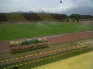
Estadio Olímpico Hermanos Ghersi Páez
Distance: Approx. 2985 meters
Latitude and longitude: 10.25861111,-67.61222222
Estadio Olímpico Hermanos Ghersi Páez is a multi-use stadium in Maracay, Venezuela. It is currently used mostly for football matches and is the home stadium of Aragua Fútbol Club. The stadium holds 14,000 people.

Estadio José Pérez Colmenares
Distance: Approx. 3202 meters
Latitude and longitude: 10.26047,-67.611626
Estadio José Pérez Colmenares is a multi-purpose stadium in Maracay, Venezuela. The stadium was named in honor of first baseman and outfielder José Pérez Colmenares, a member of the National Baseball team that won the Baseball World Cup in its 1941 edition. It is used mostly for baseball games and serves as the home of the Tigres de Aragua, a member team of the Venezuelan Professional Baseball League.

Mariscal Sucre Airport (Venezuela)
Airport in Aragua, Venezuela
Distance: Approx. 3576 meters
Latitude and longitude: 10.25,-67.64944444
Mariscal Sucre Airport (IATA: MYC, ICAO: SVBS) is an airport in the Aragua state of Venezuela, serving the city of Maracay. The airport is on the northeastern shore of Lake Valencia also named Los Tacariguas Lake . The airport is named in honor of Antonio José de Sucre, a leader of the Venezuelan War of Independence and the second president of Bolivia.

Aragua River
River in Venezuela
Distance: Approx. 6935 meters
Latitude and longitude: 10.17333,-67.60472
The Aragua River is a South America river in Aragua State, Venezuela. The river flows from the northern part of the state into the endorheic Lake Valencia, and is the lake's main tributary.

Aeronautics Museum of Maracay
Aviation museum in Maracay, Venezuela
Distance: Approx. 3625 meters
Latitude and longitude: 10.252944,-67.595033
Venezuelan Air Force's Museo Aeronáutico de Maracay (Aeronautics Museum of Maracay) is a historical aviation museum of military and civic aeronautic technology inaugurated on 10 December 1963 and located at the installations of the former Aeropuerto Nacional Florencio Gómez (the first airport in Maracay) adjacent to the Venezuelan Air Force officer graduation school, and the "Cradle of Venezuelan Military Aviation" in the City of Maracay, Estado Aragua, Venezuela. The museum is the only one of its kind in Venezuela and the largest collector and restorator of aircraft, engines, weapons, documents, photographs, maps, paintings, memorabilia and other items of historical value. The aviation museum in Maracay is one of the largest in Latin America, with over 40 aircraft on display.

El Limón, Aragua
Place in Aragua, Venezuela
Distance: Approx. 7562 meters
Latitude and longitude: 10.30027778,-67.63361111
El Limón is a city in the state of Aragua, Venezuela. It is the shire town of the Mario Briceño Iragorry Municipality. From early colonial times it was a center of cane sugar production, and it remained a small town well into the twentieth century.

Sindoni Tower
Office in Maracay, Venezuela
Distance: Approx. 3789 meters
Latitude and longitude: 10.24861111,-67.59055556
The Sindoni Tower (also known as Filippo Sindoni Tower or the Torre Sindoni in Spanish) is a building located in the Venezuelan city of Maracay. It is the highest tower in the city. It has an estimated height of 125 meters, and about 32 floors, making it the eighth tallest building in Venezuela, as well as being one of the newest buildings in height.

La Cabrera Tunnel
Tunnel in Venezuela
Distance: Approx. 6244 meters
Latitude and longitude: 10.270278,-67.664444
The La Cabrera Tunnel (Spanish: Túnel de La Cabrera), also known as the La Cabrera bridge-tunnel, is a tunnel and viaduct in Venezuela which lies within Carabobo State and connects it with Aragua State. It was built in the late 1950s using the New Austrian Tunnelling method. It was the first application by Ladislaus von Rabcewicz of systematic rock bolt and shotcrete support in a highway tunnel.
San Martín de Porres Parish (Aragua)
Parish in Venezuela
Distance: Approx. 8515 meters
Latitude and longitude: 10.17111111,-67.57638889
San Martín de Porres Parish is a Venezuelan administrative political division, located in Libertador Municipality, Aragua State, Venezuela and has an approximate population of 130,270 inhabitants. It covers almost 56% of the municipality. The San Martín de Porres Parish limits to the north with the Santa Rita Parish, to the east with the Palo Negro parish, to the south with the Palo Negro Crossroads, and to the west with the Lake of Valencia.
Weather in this IP's area
overcast clouds
23 Celsius
24 Celsius
23 Celsius
23 Celsius
1013 hPa
88 %
1013 hPa
964 hPa
10000 meters
0.33 m/s
0.69 m/s
98 degree
96 %
06:18:49
18:17:50