Country:
 Venezuela
Region:
City:
Latitude and Longitude:
Time Zone:
Postal Code:
IP information under different IP Channel
ip-api
Country
Region
City
ASN
Time Zone
ISP
Blacklist
Proxy
Latitude
Longitude
Postal
Route
IPinfo
Country
Region
City
ASN
Time Zone
ISP
Blacklist
Proxy
Latitude
Longitude
Postal
Route
MaxMind
Country
Region
City
ASN
Time Zone
ISP
Blacklist
Proxy
Latitude
Longitude
Postal
Route
Luminati
Country
VEASN
Time Zone
America/Caracas
ISP
TELEFONICA VENEZOLANA, C.A.
Latitude
Longitude
Postal
db-ip
Country
Region
City
ASN
Time Zone
ISP
Blacklist
Proxy
Latitude
Longitude
Postal
Route
ipdata
Country
Region
City
ASN
Time Zone
ISP
Blacklist
Proxy
Latitude
Longitude
Postal
Route
Popular places and events near this IP address

Rómulo Gallegos Center for Latin American Studies
Distance: Approx. 931 meters
Latitude and longitude: 10.5003,-66.848
Rómulo Gallegos Center for Latin American Studies (CELARG, Fundación Centro de Estudios Latinoamericanos Rómulo Gallegos), is a Venezuelan government foundation that aims to study and promote Latin American culture and Latin American integration, taking its inspiration from the life and work of prominent author and former president Rómulo Gallegos. It was established on July 30, 1974 by an international board chaired by Mexican philosopher Leopoldo Zea. Currently, the CELARG is an integral space where research, academic events, and cultural activities are presented and open to the general public.

Parque del Este
Distance: Approx. 1115 meters
Latitude and longitude: 10.49666667,-66.84111111
El Parque del Este (In English: "East Park"), renamed as officially Generalissimo Francisco de Miranda Park by Chávez since, in honor of the Venezuelan national hero, is a public recreation park located in the Sucre Municipality of Metropolitan Caracas in Venezuela. Opened in 1961, it is one of the most important of the city, with an area of 82 hectares (200 acres). The park was designed by Roberto Burle Marx and associates Fernando Tabora and John Stoddart.

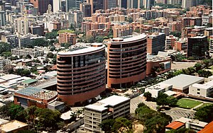
CorpBanca Tower
Office in Caracas, Venezuela
Distance: Approx. 1447 meters
Latitude and longitude: 10.4981,-66.8524
The CorpBanca Tower (Spanish: Torre CorpBanca) is a high-rise office building located in the city of Caracas, Venezuela. It is known for being the tallest skyscraper in the Financial Center of the Golden Mile of Caracas with 124 meters and 30 floors, a title that will be held in the future by the neighboring CAF Tower, when it is completed.

Parque Cristal
National historical monument of Venezuela in Caracas
Distance: Approx. 985 meters
Latitude and longitude: 10.49777778,-66.84305556
The Parque Cristal is an office and recreation building located on Avenida Francisco de Miranda in Caracas, Venezuela, which has become a famous landmark. It was seen as a symbol of development when it was constructed in 1977.

Centro San Ignacio
Shopping mall in Caracas, Venezuela
Distance: Approx. 1794 meters
Latitude and longitude: 10.4976,-66.856
Centro San Ignacio is a Venezuelan shopping mall and office complex which opened in September 1998. It won recognition for Latin American contemporary architecture with the Mies van der Rohe Award that year. The mall is in La Castellana in the Chacao area of Caracas.
La Castellana, Caracas
Neighborhood in Caracas, Venezuela
Distance: Approx. 1515 meters
Latitude and longitude: 10.50333333,-66.85583333
La Castellana is a district in Caracas, Venezuela, located in the northeast part of the city, La Castellana is bordered on the south by Chacao, on the east by Altamira (Caracas) neighbourhood, on the west by Caracas Country Club and Campo Alegre neighbourhood and on the north by El Ávila National Park. It has an approximate surface of 98 hectares (0.987 square kilometers).
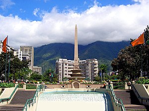
Plaza Francia (Caracas)
Distance: Approx. 1346 meters
Latitude and longitude: 10.4964,-66.849
France Square (Plaza Francia in Spanish), also known as "Plaza Altamira", is a public space located in Altamira, east Caracas. It was built at the beginning of the 1940s and opened on August 11, 1945, with the original name of "Plaza Altamira". Its name was later changed due to an agreement between the cities of Caracas and Paris to have a Venezuela Square in Paris and a France Square in Caracas.
St. Ignatius of Loyola College, Caracas
Private primary and secondary school in Venezuela
Distance: Approx. 1862 meters
Latitude and longitude: 10.49944444,-66.85777778
St. Ignatius of Loyola College, Caracas, (Colegio San Ignacio de Loyola) is a private Catholic primary and secondary school located in Caracas, Venezuela Founded by the Jesuits in 1923, the school is coeducational, and covers pre-primary through high school.
Colegio Amerigo Vespucci
School in Caracas, Venezuela
Distance: Approx. 1517 meters
Latitude and longitude: 10.49804,-66.83162
Colegio Amerigo Vespucci is an Italian private school in Caracas, Venezuela.

Altamira station
Caracas metro station
Distance: Approx. 1296 meters
Latitude and longitude: 10.49561111,-66.8385
Altamira is a Caracas Metro station on Line 1. It was opened on 23 April 1988 as part of the extension of Line 1 from Chacaíto to Los Dos Caminos. The station is between Chacao and Miranda.

Miranda station (Caracas)
Caracas metro station
Distance: Approx. 1063 meters
Latitude and longitude: 10.49719444,-66.84072222
Miranda (formerly Parque del Este) is a Caracas Metro station on Line 1. It was opened on 23 April 1988 as part of the extension of Line 1 from Chacaíto to Los Dos Caminos. The station is between Altamira and Los Dos Caminos.

Los Dos Caminos station
Caracas metro station
Distance: Approx. 1567 meters
Latitude and longitude: 10.49516667,-66.83405556
Los Dos Caminos is a Caracas Metro station on Line 1. It was opened on 23 April 1988 as the eastern terminus of the extension of Line 1 from Chacaíto. On 10 November 1989, the line was extended further to Palo Verde.
Weather in this IP's area
scattered clouds
25 Celsius
25 Celsius
20 Celsius
25 Celsius
1015 hPa
78 %
1015 hPa
911 hPa
10000 meters
1.54 m/s
330 degree
40 %
06:15:48
18:14:37