Country:
 Venezuela
Region:
City:
Latitude and Longitude:
Time Zone:
Postal Code:
IP information under different IP Channel
ip-api
Country
Region
City
ASN
Time Zone
ISP
Blacklist
Proxy
Latitude
Longitude
Postal
Route
IPinfo
Country
Region
City
ASN
Time Zone
ISP
Blacklist
Proxy
Latitude
Longitude
Postal
Route
MaxMind
Country
Region
City
ASN
Time Zone
ISP
Blacklist
Proxy
Latitude
Longitude
Postal
Route
Luminati
Country
VEASN
Time Zone
America/Caracas
ISP
TELEFONICA VENEZOLANA, C.A.
Latitude
Longitude
Postal
db-ip
Country
Region
City
ASN
Time Zone
ISP
Blacklist
Proxy
Latitude
Longitude
Postal
Route
ipdata
Country
Region
City
ASN
Time Zone
ISP
Blacklist
Proxy
Latitude
Longitude
Postal
Route
Popular places and events near this IP address

Llovizna Falls
Waterfall in Venezuela
Distance: Approx. 3683 meters
Latitude and longitude: 8.31583333,-62.67416667
Llovizna Falls is a waterfall on the Caroní River, close to its confluence with the Orinoco, are located in the Llovizna Park, Puerto Ordaz, Venezuela. The nearby Macagua Dam has reduced the flow over the waterfall in recent years, but the cascade continues to be spectacular and returns to its former glory several times a year when the floodgates of the dam are opened. (Llovizna - "yoviz-nah", is Spanish for mist, drizzle, spray).

Ciudad Guayana
Place in Bolívar, Venezuela
Distance: Approx. 8512 meters
Latitude and longitude: 8.36666667,-62.65
Ciudad Guayana (Spanish pronunciation: [sjuˈðað ɣwaˈʝana]) (English: Guayana City) is a city in Bolívar State, Venezuela. It stretches 40 kilometers along the south bank of the Orinoco river, at the point where it is joined by its main tributary, the Caroní river. The Caroní flows through the city from south to north, dividing it into its predominant halves — the old town of San Félix, to the east, and the newer area of Puerto Ordaz (Spanish pronunciation: [ˈpweɾto oɾˈðas]), to the west.

Caroní River
River in Venezuela
Distance: Approx. 3532 meters
Latitude and longitude: 8.34527778,-62.71916667
The Caroní River is the second most important river of Venezuela, the second in flow, and one of the longest, 952 kilometres (592 mi) from the Kukenan tepui through to its confluence with the Orinoco River. The name "Caroní" is applied starting from the confluence of the Kukenan with the Yuruaní River at 182 kilometres (113 mi) from the source of the Kukenan and 770 kilometres (480 mi) from its discharge in the Orinoco. The confluence takes place in Bolivar State.
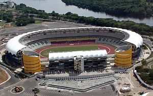
Polideportivo Cachamay
Distance: Approx. 1256 meters
Latitude and longitude: 8.3125,-62.69666667
The Estadio Cachamay is part of the Centro Total de Entretenimiento Cachamay (English: The Total Entertainment Center of Cachamay). It is a multipurpose stadium located on Avenida Guayana in Puerto Ordaz (Part of Ciudad Guayana) Bolivar State, Venezuela. The old stadium was opened in 1980 and subjected to an expansion, modernization and remodeling over the years 1990 and 2006–2007, which involved the demolition of some parts and redesign of its structure to point to double its capacity before 2006, being one of the 9 host stadiums of the 2007 Copa América, when it reopened as Cachamay CTE. It is set in grounds with beautiful natural landscapes, surrounded by the mighty river Caroni and waterfalls Cachamay Park.

Estadio La Ceiba
Distance: Approx. 5381 meters
Latitude and longitude: 8.3425,-62.66694444
Estadio La Ceiba is a multi-use stadium in the San Felix area of Ciudad Guayana, Venezuela. It is currently used mostly for baseball games. The stadium holds 30,000 people.

Roman Catholic Diocese of Ciudad Guayana
Roman Catholic diocese in Venezuela
Distance: Approx. 2658 meters
Latitude and longitude: 8.2966,-62.7221
The Roman Catholic Diocese of Ciudad Guayana (Latin: Dioecesis Civitatis Guayanensis) is a diocese located in the city of Ciudad Guayana in the ecclesiastical province of Ciudad Bolívar in Venezuela.
Universidad Experimental Politécnica Antonio José de Sucre
Distance: Approx. 4711 meters
Latitude and longitude: 8.27972,-62.73014
Universidad Experimental Politécnica Antonio José de Sucre Vicerectorado Luis Caballero Mejías is a university in Caracas.
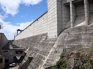
Macagua Dam
Dam in Bolívar State, Venezuela
Distance: Approx. 4550 meters
Latitude and longitude: 8.30388889,-62.66805556
The Macagua Dam, officially known as Antonio José de Sucre, is an embankment dam with concrete gravity sections on the Caroní River in Ciudad Guayana, Bolívar State, Venezuela. It is 10 kilometres (6.2 mi) upstream from the confluence of the Caroni and Orinoco Rivers, 81 km (50 mi) downstream of the Guri Dam and 22 kilometres (14 mi) downstream of the Caruachi Dam. The dam's main purpose is hydroelectric power generation and it was later named after Antonio José de Sucre.
Battle of San Félix
Distance: Approx. 9420 meters
Latitude and longitude: 8.317643,-62.622102
The Battle of San Félix was an engagement in the Guayana campaign of the War of Independence of Venezuela, that occurred on 11 April 1817, on the mesa of Chirica in Province of Guayana, over the course of just half an hour.
Loyola College Gumilla
Jesuit, catholic school in Puerto Ordaz, Ciudad Guayana, Venezuela
Distance: Approx. 1837 meters
Latitude and longitude: 8.29964167,-62.71150278
Loyola College Gumilla is a coeducational school, primary through high school, founded by the Jesuits in 1965 in Puerto Ordaz, Ciudad Guayana, Bolivar State, Venezuela.

Loefling Zoo
Zoo in Ciudad Guayana, Venezuela
Distance: Approx. 2290 meters
Latitude and longitude: 8.29555556,-62.70333333
The Loefling Zoo (Spanish: Parque Zoológico Loefling) Also Zoological Park Loefling Is a publicly owned zoological garden located southwest of Cachamay Park, in Ciudad Guayana, part of the Bolivar State in the Venezuelan Guayana region. It received its name in honor of the Swedish botanist Pehr Löfling. He was one of the first to make the fauna and flora of this region known to science, and he died near Ciudad Guayana.
Weather in this IP's area
overcast clouds
26 Celsius
26 Celsius
26 Celsius
26 Celsius
1012 hPa
77 %
1012 hPa
1010 hPa
10000 meters
1.38 m/s
2.87 m/s
200 degree
100 %
05:58:26
17:58:54