Country:
 Venezuela
Region:
City:
Latitude and Longitude:
Time Zone:
Postal Code:
IP information under different IP Channel
ip-api
Country
Region
City
ASN
Time Zone
ISP
Blacklist
Proxy
Latitude
Longitude
Postal
Route
IPinfo
Country
Region
City
ASN
Time Zone
ISP
Blacklist
Proxy
Latitude
Longitude
Postal
Route
MaxMind
Country
Region
City
ASN
Time Zone
ISP
Blacklist
Proxy
Latitude
Longitude
Postal
Route
Luminati
Country
VEASN
Time Zone
America/Caracas
ISP
TELEFONICA VENEZOLANA, C.A.
Latitude
Longitude
Postal
db-ip
Country
Region
City
ASN
Time Zone
ISP
Blacklist
Proxy
Latitude
Longitude
Postal
Route
ipdata
Country
Region
City
ASN
Time Zone
ISP
Blacklist
Proxy
Latitude
Longitude
Postal
Route
Popular places and events near this IP address

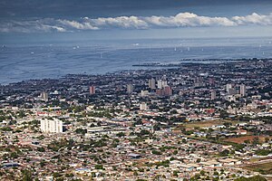
Maracaibo
Municipality in Zulia, Venezuela
Distance: Approx. 2552 meters
Latitude and longitude: 10.63333333,-71.63333333
Maracaibo ( MARR-ə-KY-boh, Spanish: [maɾaˈkajβo] ; Wayuu: Marakaaya) is a city and municipality in northwestern Venezuela, on the western shore of the strait that connects Lake Maracaibo to the Gulf of Venezuela. It is the second-largest city in Venezuela, after the national capital, Caracas, and the capital of the state of Zulia. The population of the city is approximately 2,658,355 with the metropolitan area estimated at 5,278,448 as of 2010.
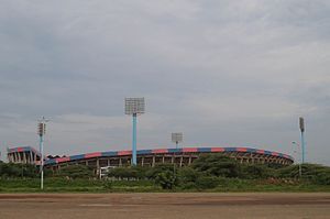
Estadio José Pachencho Romero
Distance: Approx. 5567 meters
Latitude and longitude: 10.67411389,-71.64501111
Estadio José Encarnación "Pachencho" Romero is a sports stadium in Maracaibo, capital of the Zulia state, in Venezuela. The stadium holds 40,800 spectators. The pitch was originally surrounded by both a running track and a scorched concrete cycling track, the latter being replaced with new stands due to the celebration of Copa América 2007.

Baralt Theatre
Theatre in Maracaibo, Venezuela
Distance: Approx. 5489 meters
Latitude and longitude: 10.64222222,-71.60805556
El Teatro Baralt (English: The Baralt Theatre) is a theatre in downtown Maracaibo, Venezuela, at the northwestern corner of the historic Plaza Bolívar. The first theatre at the site was built in the mid 19th century as a small performance hall, with subsequent theatre buildings there having seen many different reconstructions. A major Venezuelan cultural institution, the theatre received a National Monument designation in 1981, recognizing its location as the site of the first film screenings in the country and as a longstanding part of the historic center of Maracaibo.

Estadio Luis Aparicio El Grande
Distance: Approx. 5380 meters
Latitude and longitude: 10.672944,-71.648125
Estadio Luis Aparicio El Grande is a multi-use stadium in Maracaibo, Venezuela. It is currently used mostly for baseball games and serves as the home of Águilas del Zulia. The stadium holds 23,900 people and opened in 1963.

Basilica of Our Lady of Chiquinquirá, Maracaibo
Church in Maracaibo, Venezuela
Distance: Approx. 4970 meters
Latitude and longitude: 10.6425,-71.61326389
La Chiquinquirá Church (Spanish: Virgen de La Chiquinquirá) is a church in Maracaibo, Venezuela. The feast day of the church is November 18. Annually on this day many thousands of people gather around the church.

Maracaibo Province (Spanish Empire)
Administrative division of the Spanish Empire (1676-1824); part of present-day Venezuela
Distance: Approx. 2552 meters
Latitude and longitude: 10.63333333,-71.63333333
Maracaibo Province or Maracaybo Province from 1676 to 1824 was a province of the Spanish Empire. It resulted from a merger of the former Province of Mérida (1622 - 1676) with the territory of Maracaibo. In 1777 Captaincy General of Venezuela was created and the province was part of it.
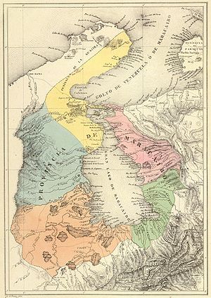
Maracaibo Province (Venezuela)
Place
Distance: Approx. 2552 meters
Latitude and longitude: 10.63333333,-71.63333333
Maracaibo Province was a historical region of Venezuela that corresponds roughtly to the actual Zulia State. The eighteenth century geographer Antonio de Alcedo mentions Maracaibo as one of the cities of the Venezuela Province, a jurisdiction of the vice-royalty of New Grenade. In 1777, the Crown of Castile reforms its American territories among which that of the contemporary Venezuela.

Palacio de Eventos de Venezuela
Convention center in Maracaibo, Venezuela
Distance: Approx. 2334 meters
Latitude and longitude: 10.60416667,-71.65388889
The Palacio de Eventos de Maracaibo is a convention center in Maracaibo, Venezuela. Its infrastructure is constituted by 6 levels that offer wide possibilities for its multifunctional use to any kind of events; and is 0.3 km away from the centre of the Maracaibo. The 7,000-seat center is the largest convention center in Maracaibo, and hosted the Miss Venezuela 2010 pageant.
Costa Oriental del Lago de Maracaibo
Region in Zulia, Venezuela
Distance: Approx. 2554 meters
Latitude and longitude: 10.6333,-71.6333
Costa Oriental del Lago de Maracaibo (in English Eastern Coast of Maracaibo Lake) is a metropolitan area and subregion, that includes seven municipalities of Zulia state. It is the main traditional area of the oil industry in Zulia and where most oilfield operations are based. It's bordered to the west by Lake Maracaibo, the east with the states of Falcón and Lara, the north with the Gulf of Venezuela, and the south with Trujillo state.
Gonzaga College, Venezuela
Jesuit, catholic school in Barrio San Jose, Maracaibo, Venezuela
Distance: Approx. 2701 meters
Latitude and longitude: 10.645025,-71.64101389
Gonzaga College is a coeducational, Jesuit school, primary through high school, presently situated in Barrio San Jose in Maracaibo, Venezuela. It was founded by the Society of Jesus in 1945.

Luxburg-Carolath Cemetery
Distance: Approx. 4736 meters
Latitude and longitude: 10.65,-71.62
The Luxburg-Carolath Cemetery (Spanish: Cementerio Luxburg-Carolath), commonly known as El Cuadrado ("The Square") is a privately owned cemetery located in Maracaibo, Zulia, Venezuela. It is one of the oldest operating cemeteries in the country, and has over 10,000 interments.

Hotel Europa
Former hotel in Venezuela
Distance: Approx. 5519 meters
Latitude and longitude: 10.64102778,-71.60733333
The Hotel Europa was a grand hotel located in Maracaibo, Venezuela. It opened in the late 19th century and served as the filming location for the first Venezuelan film, Un célebre especialista sacando muelas en el gran Hotel Europa, in 1897. Later, it was converted into other hotels with different names, most notably the Hotel Zulia, before being demolished in 1956 for the construction of the Maracaibo municipal building.
Weather in this IP's area
moderate rain
25 Celsius
26 Celsius
25 Celsius
25 Celsius
1011 hPa
92 %
1011 hPa
1008 hPa
10000 meters
0.55 m/s
1.91 m/s
222 degree
100 %
06:35:05
18:33:49