Country:
Region:
City:
Latitude and Longitude:
Time Zone:
Postal Code:
IP information under different IP Channel
ip-api
Country
Region
City
ASN
Time Zone
ISP
Blacklist
Proxy
Latitude
Longitude
Postal
Route
Luminati
Country
Region
cmx
City
gustavoadolfomadero
ASN
Time Zone
America/Mexico_City
ISP
Universidad Pedagogica Nacional
Latitude
Longitude
Postal
IPinfo
Country
Region
City
ASN
Time Zone
ISP
Blacklist
Proxy
Latitude
Longitude
Postal
Route
db-ip
Country
Region
City
ASN
Time Zone
ISP
Blacklist
Proxy
Latitude
Longitude
Postal
Route
ipdata
Country
Region
City
ASN
Time Zone
ISP
Blacklist
Proxy
Latitude
Longitude
Postal
Route
Popular places and events near this IP address

CINVESTAV
Mexican scientific research institution
Distance: Approx. 3360 meters
Latitude and longitude: 19.50916667,-99.12944444
The Center for Research and Advanced Studies of the National Polytechnic Institute (in Spanish: Centro de Investigación y de Estudios Avanzados del Instituto Politécnico Nacional or simply as CINVESTAV-IPN) is a Mexican non-governmental scientific research institution affiliated with the National Polytechnic Institute and founded by president Adolfo López Mateos on 17 April 1961, initially planned as a postgraduate department of the National Polytechnic Institute; this was later modified by President José López Portillo, on 17 September 1982. The modification by President Portillo stipulates that it is a decentralized organ of public interest, with legal personality and own patrimony. Cinvestav receives an annual subsidy by the Federal Government to fund its operations.

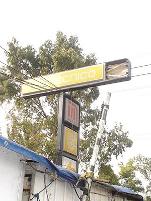
Politécnico metro station
Mexico City Metro station
Distance: Approx. 3954 meters
Latitude and longitude: 19.50082,-99.149294
Politécnico metro station is a Mexico City Metro station in Gustavo A. Madero, Mexico City. It is an at-grade station with two side platforms that serves as the northern terminus of Line 5 (the Yellow line). It is followed by Instituto del Petróleo station.

Estadio Wilfrido Massieu
Distance: Approx. 3835 meters
Latitude and longitude: 19.50194444,-99.13861111
Estadio Wilfrido Massieu is an outdoor stadium located north of Mexico City, within the "Adolfo Lopez Mateos" campus of the National Polytechnic Institute (IPN). It was built in 1959 and has a capacity of 15,000 spectators. The stadium is the home field of the IPN's college football teams: the Águilas Blancas and Burros Blancos .

ESCOM
Distance: Approx. 3461 meters
Latitude and longitude: 19.505,-99.14666667
The Higher School of Computing (in Spanish: Escuela Superior de Cómputo or ESCOM) is the college specialized in Computer Sciences of the National Polytechnic Institute located in Mexico City, Mexico. Its students pursue the bachelor's degree in computer engineering, artificial intelligence engineering and data science. The school has a faculty mostly with postgraduate studies, and there is a growing number of teachers with doctoral studies.

Santa Cecilia Acatitlan
Distance: Approx. 3579 meters
Latitude and longitude: 19.55258333,-99.17333333
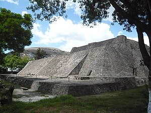
Acatitlan (Nahuatl: "place among the reeds"; Spanish "carrizal") is an archeological zone of the early Aztec (or early Toltec) culture located in the town of Santa Cecilia, in the municipality of Tlalnepantla de Baz in the State of Mexico, about 10 km northwest of Mexico City. In pre-Columbian times, it was located on the northwest shore of the great Lake Texcoco.

Tenayuca
Archaeological site in Mexico
Distance: Approx. 2592 meters
Latitude and longitude: 19.53216667,-99.16847222
Tenayuca (Nahuatl languages: Tenanyohcān pronounced [te.naˈyoʔ.kaːn]) is a pre-Columbian Mesoamerican archaeological site in the Valley of Mexico. In the Postclassic period of Mesoamerican chronology, Tenayuca was a settlement on the former shoreline of the western arm of Lake Texcoco. It was located approximately 10 kilometres (6.2 mi) to the northwest of Tenochtitlan (the heart of present-day Mexico City).
XHIPN-FM
IPN radio station in Mexico City
Distance: Approx. 1466 meters
Latitude and longitude: 19.53277778,-99.13055556
XHIPN-FM, known as Radio IPN, is the radio station of the Instituto Politécnico Nacional in Mexico City. The studios are located at the IPN's Allende Continuing Education Center; the transmitter is located atop Cerro del Chiquihuite.

UPIITA
School of the National Polytechnic Institute in Mexico
Distance: Approx. 3386 meters
Latitude and longitude: 19.51111111,-99.12555556
The Interdisciplinary Professional Unit in Engineering and Advanced Technologies (in Spanish: Unidad Profesional Interdisciplinaria en Ingeniería y Tecnologías Avanzadas or UPIITA) is one of the schools of the National Polytechnic Institute, located in Mexico City, Mexico. It offers undergraduate studies in Bionics, Telematics, Mechatronics, and Energy engineering, as well as postgraduate programs in Advanced Technology. UPIITA is currently one of the most demanded engineering schools in Mexico.
Instituto Politécnico Nacional
University in Mexico
Distance: Approx. 3972 meters
Latitude and longitude: 19.50055556,-99.13972222
The National Polytechnic Institute (Spanish: Instituto Politécnico Nacional), abbreviated IPN, is one of the largest public universities in Mexico with 171,581 students at the high school, undergraduate and postgraduate levels. It is the second-best university in Mexico in the technical and engineering domain according to the QS World University Rankings by Subject 2018. It was founded on 1 January 1936 during the administration of President Lázaro Cárdenas.
Benemerito De Las Americas
School
Distance: Approx. 983 meters
Latitude and longitude: 19.53811,-99.1532
La Preparatoria Benemérito de las Américas, officially named El Centro Escolar Benemérito de las Américas (CEBA) was a private high school operated by the Church of Jesus Christ of Latter-day Saints (LDS Church) in Mexico City. At the end of the 2012–13 school year, the LDS Church converted the school to a Missionary Training Center (MTC).

XHHCU-TDT
Canal del Congreso TV station in Mexico City
Distance: Approx. 1487 meters
Latitude and longitude: 19.53516389,-99.12995278
XHHCU-TDT is a television station in Mexico City, broadcasting on UHF channel 45. The station received its permit in 2010 and signed on July 16, 2015, as the first over-the-air outlet of the Canal del Congreso.
Cerro del Chiquihuite
Hill in Mexico City
Distance: Approx. 1466 meters
Latitude and longitude: 19.53277778,-99.13055556
Cerro del Chiquihuite (Chiquihuite Hill) is a hill located in the north of Mexico City, in the borough of Gustavo A. Madero and bordering the municipality of Tlalnepantla de Baz in the State of Mexico. The hill has a height of 2,730 metres (8,960 ft) above sea level and forms part of the Sierra de Guadalupe mountain range. It was used as a filming location for the 1993 Mexican film Lolo.
Weather in this IP's area
scattered clouds
18 Celsius
17 Celsius
18 Celsius
19 Celsius
1011 hPa
67 %
1011 hPa
782 hPa
10000 meters
3.6 m/s
90 degree
40 %
06:39:11
18:01:05
