Country:
 Brazil
Region:
City:
Latitude and Longitude:
Time Zone:
Postal Code:
IP information under different IP Channel
ip-api
Country
Region
City
ASN
Time Zone
ISP
Blacklist
Proxy
Latitude
Longitude
Postal
Route
IPinfo
Country
Region
City
ASN
Time Zone
ISP
Blacklist
Proxy
Latitude
Longitude
Postal
Route
MaxMind
Country
Region
City
ASN
Time Zone
ISP
Blacklist
Proxy
Latitude
Longitude
Postal
Route
Luminati
Country
BRRegion
sp
City
sorocaba
ASN
Time Zone
America/Sao_Paulo
ISP
SENCINET LATAM BRASIL LTDA
Latitude
Longitude
Postal
db-ip
Country
Region
City
ASN
Time Zone
ISP
Blacklist
Proxy
Latitude
Longitude
Postal
Route
ipdata
Country
Region
City
ASN
Time Zone
ISP
Blacklist
Proxy
Latitude
Longitude
Postal
Route
Popular places and events near this IP address

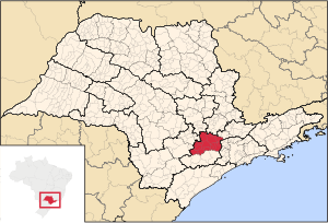
Sorocaba
Municipality in Southeast Brazil, Brazil
Distance: Approx. 3505 meters
Latitude and longitude: -23.50166667,-47.45805556
Sorocaba (Portuguese pronunciation: [soɾoˈkabɐ]) is a municipality in the interior of the state of São Paulo, Brazil. With over 723,000 inhabitants, it is the seventh-largest city in the state and the second-largest outside the Greater São Paulo region, ranking behind only Campinas. It forms its own Metropolitan Region of Sorocaba, comprising 27 municipalities with a total population of 2 million inhabitants, the 15th most populous in Brazil.
Faculdade de Engenharia de Sorocaba
Distance: Approx. 1361 meters
Latitude and longitude: -23.4699,-47.4298
Faculdade de Engenharia de Sorocaba (FACENS) The Sorocaba Engineering School (FACENS) is the first higher education institution of the sector founded in Sorocaba. Maintained by the Sorocaba Cultural Association for Technological Renovation (ACRTS), it is considered to be a nonprofit and philanthropic Federal Organization certified by the National Welfare Council. Subsequently, it offers numerous grants to students who have socio-economic needs.

Votorantim
Municipality in Southeast
Distance: Approx. 8179 meters
Latitude and longitude: -23.54694444,-47.43777778
Votorantim (Portuguese pronunciation: [votoɾɐ̃ˈtʃĩ]) is a city located at the southwest of São Paulo State in Brazil. It is part of the Metropolitan Region of Sorocaba. The population is 123,599 (2020 est.).
Microregion of Sorocaba
Microregion in Southeast, Brazil
Distance: Approx. 3520 meters
Latitude and longitude: -23.50194444,-47.45777778
The Microregion of Sorocaba (Portuguese: Microrregião de Sorocaba) is a microregion in the central part of São Paulo State, Brazil.

Roman Catholic Archdiocese of Sorocaba
Catholic ecclesiastical territory
Distance: Approx. 3387 meters
Latitude and longitude: -23.5003,-47.4584
The Roman Catholic Archdiocese of Sorocaba (Latin: Archidioecesis Sorocabana) is an archdiocese located in the city of Sorocaba in Brazil.

Municipal Zoological Park Quinzinho de Barros
Zoo in state of São Paulo, Brazil
Distance: Approx. 3617 meters
Latitude and longitude: -23.50583333,-47.43805556
The Municipal Zoological Park "Quinzinho de Barros" (the City Zoo of Sorocaba) is a 15-hectare (37-acre) zoo located in the municipality of Sorocaba, state of São Paulo, Brazil. It is a member of the Society of Brazilian Zoos (SZB), and is considered Brazil's second zoo in terms of species. The zoo lies in the Vila Hortência district, in the eastern area of the town of Sorocaba and covers an area of approximately 15 ha (37 acres).

Sorocaba Airport
Airport
Distance: Approx. 4872 meters
Latitude and longitude: -23.47777778,-47.49
Bertram Luiz Leupolz Airport (IATA: SOD, ICAO: SDCO) is the airport serving Sorocaba, Brazil. It is operated by Rede Voa.
Sorocaba Metropolitan Cathedral
Distance: Approx. 3347 meters
Latitude and longitude: -23.49984167,-47.45851111
The Sorocaba Metropolitan Cathedral or Metropolitan Cathedral of "Nossa Senhora da Ponte", home of Archdiocese of Sorocaba, located in the Plaza Coronel Fernando Prestes in downtown area of the city of Sorocaba, São Paulo, Brazil. It was built over 200 years ago. The cathedral is derived from the mother church of the second city, founded in 1771 when he arrived in Portugal the image Nossa Senhora da Ponte, which currently is at the main altar in style Baroque, 1771 .

Estádio Municipal Walter Ribeiro
Football Stadium in Brazil
Distance: Approx. 1898 meters
Latitude and longitude: -23.48955556,-47.44905556
Estádio Municipal Walter Ribeiro is a stadium in Sorocaba, Brazil. It has a capacity of 13,722 spectators. It is the home of Esporte Clube São Bento and Clube Atlético Sorocaba.
Weather in this IP's area
broken clouds
31 Celsius
33 Celsius
31 Celsius
31 Celsius
1010 hPa
55 %
1010 hPa
949 hPa
10000 meters
7.55 m/s
10.27 m/s
164 degree
69 %
06:01:00
18:05:12