Country:
Region:
City:
Latitude and Longitude:
Time Zone:
Postal Code:
IP information under different IP Channel
ip-api
Country
Region
City
ASN
Time Zone
ISP
Blacklist
Proxy
Latitude
Longitude
Postal
Route
Luminati
Country
Region
sp
City
saopaulo
ASN
Time Zone
America/Sao_Paulo
ISP
DC MATRIX INTERNET SA
Latitude
Longitude
Postal
IPinfo
Country
Region
City
ASN
Time Zone
ISP
Blacklist
Proxy
Latitude
Longitude
Postal
Route
db-ip
Country
Region
City
ASN
Time Zone
ISP
Blacklist
Proxy
Latitude
Longitude
Postal
Route
ipdata
Country
Region
City
ASN
Time Zone
ISP
Blacklist
Proxy
Latitude
Longitude
Postal
Route
Popular places and events near this IP address

Prestes Maia (building)
Squatted highrise building in São Paulo, Brazil
Distance: Approx. 285 meters
Latitude and longitude: -23.53507222,-46.6337
The Prestes Maia building, or sometimes simply Prestes Maia (Portuguese pronunciation: [ˈpɾɛstʃiz ˈmajjɐ]), is believed to be the largest squatted highrise building in South America, with an estimated 2000 inhabitants. The complex is made up of two tower blocks, Bloco A and Bloco B, the latter of which has the address Avenida Prestes Maia, 911 near Luz Station in downtown São Paulo. Businessman Jorge Nacle Hamuche purchased the building at auction in 1993 and co-owns it with his business partner, Eduardo Amorim.
Museum of the Portuguese Language
Language museum in São Paulo, Brazil
Distance: Approx. 186 meters
Latitude and longitude: -23.53503333,-46.63661667
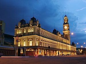
The Museum of the Portuguese Language (Portuguese: Museu da Língua Portuguesa, [muˈzew dɐ ˈlĩɡwɐ poʁtuˈɡezɐ]) is an interactive Portuguese language—and Linguistics/Language Development in general—museum in São Paulo, Brazil. It is housed in the Estação da Luz railway station, in the urban district of the same name. Three hundred thousand passengers arrive and leave the station every day, and the choice of the building for the launching of the museum is connected to the fact that it was mainly here that thousands of non-Portuguese speaking immigrants arriving from Europe and Asia into São Paulo via the Port of Santos got acquainted with the language for the first time.

Luz Station
Railway station in São Paulo, Brazil
Distance: Approx. 179 meters
Latitude and longitude: -23.535,-46.63527778
Luz Station (Portuguese: Estação da Luz, IPA: [(i)staˈsɐ̃w dɐ ˈlus]) is a commuter rail and intercity rail station in the Bom Retiro district of São Paulo, Brazil, serving RFFSA, the intercity rail network of Brazil, CPTM Line 7-Ruby, Line 11-Coral and Line 13–Jade (Airport-Express). It has subway connections to São Paulo Metro Line 1-Blue and ViaQuatro Line 4-Yellow via its underground metro station of the same name. It is currently located in Bairro da Luz and was driven between the years of 1895 and 1901, designed by the British architect Charles Henry Driver for the São Paulo Railway, a company based in London and which was responsible for building the first railway line in the state of São Paulo, ligand or port of Santos à cidade de Jundiaí.

Sala São Paulo
Concert hall in Campos Elíseos, São Paulo.
Distance: Approx. 397 meters
Latitude and longitude: -23.53416667,-46.63972222
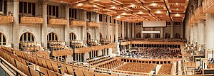
The Júlio Prestes Cultural Center, which is located in the Júlio Prestes Train Station in the old north central section of the city of São Paulo, Brazil, was inaugurated on July 9, 1999. The building has been restored and renovated by the São Paulo State Government, as part of the downtown revitalization in that city. It houses the Sala São Paulo, which has a capacity of 1498 seats and is the home of the São Paulo State Symphonic Orchestra (OSESP).

Jardim da Luz
Park in São Paulo
Distance: Approx. 107 meters
Latitude and longitude: -23.533,-46.635
Jardim da Luz (also: Praça da Luz or Parque da Luz) is a public park near the Luz station and Avenida Tiradentes in the Bom Retiro district of São Paulo. The headquarters of the Pinacoteca do Estado de São Paulo is located in the southeastern corner of the park.

Anhangabaú River
River in São Paulo state, Brazil
Distance: Approx. 263 meters
Latitude and longitude: -23.53333333,-46.63333333
The Anhangabaú River (in Portuguese: Rio Anhangabaú) is a river of São Paulo state in southeastern Brazil. The Anhangabaú River cuts through the very oldest part of central São Paulo, though it has been canalized since the first decade of the 20th century. The green space and plazas above the subterranean river is a popular place for various large public gatherings, including cultural events at the annual Virada Cultural, as well as numerous political protests.

Pinacoteca do Estado de São Paulo
Art museum in São Paulo, Brazil
Distance: Approx. 231 meters
Latitude and longitude: -23.53444444,-46.63388889
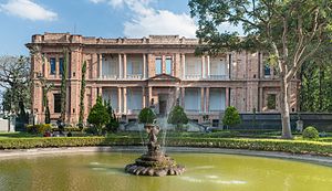
The Pinacoteca do Estado de São Paulo (Portuguese for "pinacotheca (picture gallery) of the state of São Paulo") is one of the most important art museums in Brazil. It is housed in a 1900 building in Jardim da Luz, Downtown São Paulo, designed by Ramos de Azevedo and Domiziano Rossi to be the headquarters of the Lyceum of Arts and Crafts. It is the oldest art museum in São Paulo, founded on December 24, 1905, and established as a public state museum since 1911.

Luz (São Paulo Metro)
São Paulo Metro station
Distance: Approx. 315 meters
Latitude and longitude: -23.536111,-46.634722
Luz is a metro station located between República and Sé districts, in the central region of São Paulo. This station connects the lines 1-Blue, operated by Companhia do Metropolitano de São Paulo, and 4-Yellow, operated by ViaQuatro. It also has connection with the CPTM station, which attends lines 7-Ruby and 11-Coral with no additional cost, and Line 13-Jade (Airport-Express).

Pinheiros (São Paulo Metro)
São Paulo Metro station
Distance: Approx. 315 meters
Latitude and longitude: -23.536111,-46.634722
Pinheiros is a metro station on Line 4-Yellow of the Brazilian São Paulo Metro operated by ViaQuatro. Already completed, passengers may transfer without any fee to Line 9-Emerald of ViaMobilidade.

Igreja de São Cristóvão (São Paulo)
Church in São Paulo, Brazil
Distance: Approx. 335 meters
Latitude and longitude: -23.535,-46.63305556
Igreja de São Cristóvão is a church located in São Paulo, Brazil on the Avenida Tiradentes.

Osasco (CPTM)
Train station in Brazil
Distance: Approx. 315 meters
Latitude and longitude: -23.536111,-46.634722
Osasco is a train station on ViaMobilidade Lines 8-Diamond and 9-Emerald, located in the city of Osasco.

Pinheiros (CPTM)
Railway station in São Paulo, Brazil
Distance: Approx. 315 meters
Latitude and longitude: -23.536111,-46.634722
Pinheiros is a train station on ViaMobilidade Line 9-Emerald, with connection with ViaQuatro Line 4-Yellow. It is located in the district of Pinheiros in São Paulo.
Weather in this IP's area
light rain
21 Celsius
21 Celsius
20 Celsius
21 Celsius
1016 hPa
93 %
1016 hPa
932 hPa
5000 meters
2.57 m/s
70 degree
100 %
05:19:02
18:21:06