Country:
 Brazil
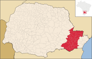
Region:
City:
Latitude and Longitude:
Time Zone:
Postal Code:
IP information under different IP Channel
ip-api
Country
Region
City
ASN
Time Zone
ISP
Blacklist
Proxy
Latitude
Longitude
Postal
Route
IPinfo
Country
Region
City
ASN
Time Zone
ISP
Blacklist
Proxy
Latitude
Longitude
Postal
Route
MaxMind
Country
Region
City
ASN
Time Zone
ISP
Blacklist
Proxy
Latitude
Longitude
Postal
Route
Luminati
Country
BRRegion
pr
City
pontagrossa
ASN
Time Zone
America/Sao_Paulo
ISP
CIA. DE TECNOL. DA INFOR. E COMUNICACAO DO PARANA
Latitude
Longitude
Postal
db-ip
Country
Region
City
ASN
Time Zone
ISP
Blacklist
Proxy
Latitude
Longitude
Postal
Route
ipdata
Country
Region
City
ASN
Time Zone
ISP
Blacklist
Proxy
Latitude
Longitude
Postal
Route
Popular places and events near this IP address

Curitiba
Capital city of Paraná, Brazil
Distance: Approx. 840 meters
Latitude and longitude: -25.42972222,-49.27111111
Curitiba (Brazilian Portuguese: [kuɾiˈtʃibɐ]) is the capital and largest city in the state of Paraná in Southern Brazil. The city's population was 1,773,718 as of 2022, making it the eighth most populous city in Brazil and the largest in Brazil's South Region. The Curitiba Metropolitan area comprises 29 municipalities with a total population of over 3,559,366, making it the ninth most populous metropolitan area in the country.

South Region, Brazil
Region in Brazil
Distance: Approx. 545 meters
Latitude and longitude: -25.43333333,-49.26666667
The South Region of Brazil (Região Sul do Brasil [ʁeʒiˈɐ̃w ˈsuw du bɾaˈziw]) is one of the five regions of Brazil. It includes the states of Paraná, Rio Grande do Sul, and Santa Catarina, and covers 576,409.6 square kilometres (222,553.0 sq mi), being the smallest region of the country, occupying only about 6.76% of the territory of Brazil. Its whole area is smaller than that of the state of Minas Gerais, in Southeast Brazil, for example or the whole metropolitan France.

Federal University of Paraná
University in Paraná, Brazil
Distance: Approx. 959 meters
Latitude and longitude: -25.42888889,-49.2675
The Federal University of Paraná (Portuguese: Universidade Federal do Paraná, UFPR) is a public university headquartered in Curitiba, Paraná, Brazil. UFPR is considered to be one of the oldest universities in Brazil. UFPR ranks as 37th best university in Latin-America and it is among the 651-700 best universities in the world, according to QS World University Rankings.

Arena da Baixada
Football stadium in Paraná, Brazil
Distance: Approx. 1422 meters
Latitude and longitude: -25.44833333,-49.27694444
Estádio Mario Celso Petraglia (Formerly known as Estádio Joaquim Américo Guimarães), also known as Ligga Arena for sponsorship reasons or Arena da Baixada, is a stadium located in Curitiba, the state capital of Paraná, Brazil. It is the home stadium of Club Athletico Paranaense, and has a capacity of 42,372 people. The stadium was the first in Brazil to sell its naming rights; it was known as Kyocera Arena between 2005 and 1 April 2008.

Estádio Vila Capanema
Distance: Approx. 1446 meters
Latitude and longitude: -25.43944444,-49.25583333
Estádio Durival Britto e Silva, better known as Estádio Vila Capanema (Portuguese for Capanema Borough Stadium), is the main stadium of Paraná Clube in Curitiba, Paraná, Brazil. The other stadium is Estádio Vila Olímpica, currently being used for training. The stadium holds 20,000 people.

Rua XV de Novembro
Distance: Approx. 714 meters
Latitude and longitude: -25.43083333,-49.27083333
Rua XV de Novembro (15 November Street) is one of the major streets in downtown Curitiba. Also known as Rua das Flores (Flower Street), it is one of the first major pedestrian streets in Brazil. It was inaugurated in 1972, with well-tended pots of flowers and tourist restaurants installed in hundred-year-old buildings.

Federal University of Technology – Paraná
Federal university in the state of Paraná, Brazil
Distance: Approx. 257 meters
Latitude and longitude: -25.43925,-49.268833
The Federal University of Technology – Paraná (Portuguese: Universidade Tecnológica Federal do Paraná, UTFPR) is a federal university with campuses in thirteen cities located in the state of Paraná. UTFPR is one of the most renowned Universities in Brazil. Their teaching pattern is inspired by the European polytechnic university model.

Teatro Guaíra
Distance: Approx. 1102 meters
Latitude and longitude: -25.4282,-49.26542778
The Teatro Guaíra Cultural Centre is a state-run cultural institution located in Curitiba, Paraná. It was built in 1945 at Santos Andrade Square. The theater has about 3,000 seats in three different auditoria, and is one of the largest concert halls in Latin America.
Greater Curitiba
Distance: Approx. 856 meters
Latitude and longitude: -25.4297,-49.2719
The Metropolitan Region of Curitiba, also known as Greater Curitiba, brings together 29 municipalities in the state of Paraná in a relative process of conurbation. The term refers to the extension of the capital of Paraná, forming with its bordering (or close) municipalities a continuous urban area. The population in 2022, according to the Brazilian Institute for Geography and Statistics was of 3,559,366 inhabitants.
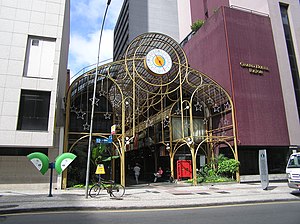
Rua 24 Horas
Shopping mall in Curitiba, Brazil
Distance: Approx. 741 meters
Latitude and longitude: -25.434329,-49.276647
Rua 24 Horas is a shopping mall in Curitiba, Brazil.

Cathedral Basilica Minor of Our Lady of Light, Curitiba
Church in Curitiba, Brazil
Distance: Approx. 968 meters
Latitude and longitude: -25.4286,-49.2714
The Cathedral Basilica Minor of Our Lady of Light (Portuguese: Catedral Basílica Menor Nossa Senhora da Luz), also called Curitiba Cathedral, is a Catholic church in the city of Curitiba, in the state of Paraná in Brazil. In 1668, a small wooden church was built on the site, in the old town of Curitiba today, with a church dedicated to Our Lady of Light and Jesus. In 1693, the City Council was established in the place in order to elect the first municipal authorities.
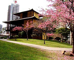
Japan Square
A public square in Curitiba, Brazil.
Distance: Approx. 1980 meters
Latitude and longitude: -25.44583333,-49.28722222
Japan Square is a public space in the city of Curitiba, the capital of the Brazilian state of Paraná. It was built in honor of the Japanese immigrants to Brazil who arrived starting in 1910. Paraná has the second-largest Japanese community in Brazil, behind São Paulo, and as of 2023 is home to more than 32,000 of its descendants.
Weather in this IP's area
mist
19 Celsius
19 Celsius
18 Celsius
20 Celsius
1021 hPa
70 %
1021 hPa
920 hPa
3000 meters
06:21:33
18:08:02