Country:
 Brazil
Region:
City:
Latitude and Longitude:
Time Zone:
Postal Code:
IP information under different IP Channel
ip-api
Country
Region
City
ASN
Time Zone
ISP
Blacklist
Proxy
Latitude
Longitude
Postal
Route
IPinfo
Country
Region
City
ASN
Time Zone
ISP
Blacklist
Proxy
Latitude
Longitude
Postal
Route
MaxMind
Country
Region
City
ASN
Time Zone
ISP
Blacklist
Proxy
Latitude
Longitude
Postal
Route
Luminati
Country
BRASN
Time Zone
America/Sao_Paulo
ISP
Scala Data Centers
Latitude
Longitude
Postal
db-ip
Country
Region
City
ASN
Time Zone
ISP
Blacklist
Proxy
Latitude
Longitude
Postal
Route
ipdata
Country
Region
City
ASN
Time Zone
ISP
Blacklist
Proxy
Latitude
Longitude
Postal
Route
Popular places and events near this IP address
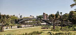
Santo André, São Paulo
Municipality in Southeast, Brazil
Distance: Approx. 4376 meters
Latitude and longitude: -23.65722222,-46.53333333
Santo André (Portuguese pronunciation: [sɐ̃twɐ̃ˈdɾɛ], Saint Andrew) is a Brazilian municipality located in the Metropolitan Region of São Paulo. It is part of a group of municipalities known as the ABC Region. According to the most recent census in 2022, the population is estimated at 748,919 in an area of 175.8 km².
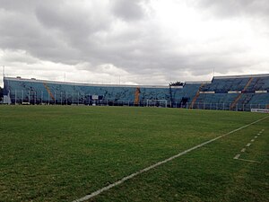
Estádio Anacleto Campanella
Distance: Approx. 887 meters
Latitude and longitude: -23.63011667,-46.559875
Estádio Municipal Anacleto Campanella, usually simply Estádio Anacleto Campanella - between 1964 and 1989 known as Estádio Municipal Lauro Gomes de Almeida, or for short Lauro Gomes, is an association football stadium in São Caetano do Sul, on the outskirts of São Paulo, Brazil. The stadium holds 16,744 people. It was inaugurated in 1955.

Heliópolis
Informal settlement in São Paulo, Brazil
Distance: Approx. 4064 meters
Latitude and longitude: -23.61055556,-46.5925
Heliópolis is a favela in the Sacomã district of São Paulo. It has around 200,000 inhabitants and has developed into a serviced neighbourhood from its beginnings as a squatted settlement in the 1970s.

Federal University of ABC
Public federal university in São Paulo, Brazil
Distance: Approx. 3671 meters
Latitude and longitude: -23.645,-46.528
Federal University of ABC (Portuguese: Universidade Federal do ABC, UFABC) is a Brazilian federal public institution of higher learning based in Santo André and São Bernardo do Campo, municipalities belonging to the ABC region, both in the state of São Paulo. UFABC is the only federal university in Brazil with 100% of its professors holding PhDs and, for the second consecutive year in 2011, emerged as the only university in Brazil with impact factor in scientific publications above the world average according to SCImago Institutions Rankings. The institution was evaluated by the General Course Index (IGC) of the Ministry of Education (MEC) as the best university in the State of São Paulo, being rated as the 1st in the ranking of undergraduate courses among all universities in Brazil.

Sacomã
District of São Paulo, Brazil
Distance: Approx. 4422 meters
Latitude and longitude: -23.6139,-46.5973
Sacomã is one of 96 districts in the city of São Paulo, Brazil. Sacomã is a district located in the southeast region of the municipality of São Paulo, in the state of São Paulo, Brazil. From a cultural and traditional point of view, the district of Sacomã is linked to the district of Ipiranga.

São Lucas (São Paulo Metro)
São Paulo Metro station
Distance: Approx. 3989 meters
Latitude and longitude: -23.5889,-46.544644
São Lucas is a monorail station of the São Paulo Metro. Belongs to Line 15–Silver, which is currently in expansion, and should reach the district of Cidade Tiradentes, with connection with Line 2–Green in Vila Prudente. It is placed in Av.

Camilo Haddad (São Paulo Metro)
São Paulo Metro station
Distance: Approx. 3597 meters
Latitude and longitude: -23.595354,-46.537678
Camilo Haddad is a monorail station of São Paulo Metro. Belongs to Line 15-Silver, which is actually in expansion, and should go to Cidade Tiradentes, with connection with Line 2-Green in Vila Prudente. It is placed in Av.

Vila Tolstói (São Paulo Metro)
São Paulo Metro station
Distance: Approx. 3964 meters
Latitude and longitude: -23.600801,-46.525163
Vila Tolstói is a monorail station of São Paulo Metro. Belongs to Line 15-Silver, which is actually in expansion, and should go to Cidade Tiradentes, with connection with Line 2-Green in Vila Prudente. It is placed in Av.

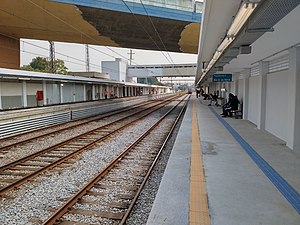
São Caetano do Sul-Pref. Walter Braido (CPTM)
Railway station in São Paulo, Brazil
Distance: Approx. 1175 meters
Latitude and longitude: -23.6261442,-46.544078
São Caetano do Sul-Prefeito Walter Braido, unofficially called only as São Caetano or São Caetano do Sul, is a train station on CPTM Line 10-Turquoise. The station is located in the center of the city of São Caetano do Sul, in the ABC Region. In January 2015, the then-called São Caetano station was renamed to São Caetano do Sul-Prefeito Walter Braido.
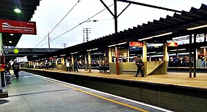
Utinga (CPTM)
Railway station in São Paulo, Brazil
Distance: Approx. 1175 meters
Latitude and longitude: -23.6261442,-46.544078
Utinga is a train station on CPTM Line 10-Turquoise, located in the district of Utinga, city of Santo André.
Prefeito Saladino (CPTM)
Railway station in São Paulo, Brazil
Distance: Approx. 2530 meters
Latitude and longitude: -23.6384257,-46.5365893
Prefeito Saladino is a train station on CPTM Line 10-Turquoise, located in the city of Santo André.
Pref. Celso Daniel-Santo André (CPTM)
Railway station in São Paulo, Brazil
Distance: Approx. 4228 meters
Latitude and longitude: -23.652244,-46.528221
Prefeito Celso Daniel-Santo André, or informally known only as Santo André, is a train station on CPTM Line 10 (Turquoise), in the city of Santo André.
Weather in this IP's area
clear sky
23 Celsius
23 Celsius
20 Celsius
24 Celsius
1015 hPa
62 %
1015 hPa
930 hPa
10000 meters
2.57 m/s
50 degree
05:46:04
18:05:15