Country:
Region:
City:
Latitude and Longitude:
Time Zone:
Postal Code:
IP information under different IP Channel
ip-api
Country
Region
City
ASN
Time Zone
ISP
Blacklist
Proxy
Latitude
Longitude
Postal
Route
Luminati
Country
ASN
Time Zone
America/Sao_Paulo
ISP
Scala Data Centers
Latitude
Longitude
Postal
IPinfo
Country
Region
City
ASN
Time Zone
ISP
Blacklist
Proxy
Latitude
Longitude
Postal
Route
db-ip
Country
Region
City
ASN
Time Zone
ISP
Blacklist
Proxy
Latitude
Longitude
Postal
Route
ipdata
Country
Region
City
ASN
Time Zone
ISP
Blacklist
Proxy
Latitude
Longitude
Postal
Route
Popular places and events near this IP address

Hospital das Clínicas da Universidade de São Paulo
Hospital in SP, Brazil
Distance: Approx. 1094 meters
Latitude and longitude: -23.55703,-46.669848
The Hospital das Clínicas da Faculdade de Medicina da Universidade de São Paulo (University of São Paulo Faculty of Medicine Clinics Hospital) is a complex of health institutions, located in various regions of the city of São Paulo, Brazil. Founded on April 19, 1944, it occupies a total area of 600,000 square meters and offers 2,400 beds, distributed among its eight specialized institutes and two assisting hospitals. The main complex of the institution is also connected to a metro station.

Heart Institute, University of São Paulo
Distance: Approx. 1281 meters
Latitude and longitude: -23.55704,-46.667729
The Heart Institute, University of São Paulo (Portuguese: Instituto do Coração da Universidade de São Paulo, or InCor) is one of the clinical institutes of the central University's teaching hospital (Hospital das Clínicas da Universidade de São Paulo) and recognized as one of the world's academic and clinical excellence centers in cardiology, cardiovascular medicine and cardiovascular surgery. The Heart Institute was founded in 1963 (1963) by the noted cardiovascular surgeon and professor of the Faculty of Medicine of the University of São Paulo, Dr. Euryclides de Jesus Zerbini.
D.O.M. (restaurant)
Brazilian restaurant
Distance: Approx. 1231 meters
Latitude and longitude: -23.56613889,-46.66758333
D.O.M. (Latin abbreviation of Deo optimo maximo) is a Brazilian cuisine restaurant in São Paulo run by Brazilian chef Alex Atala. Known for the use of native Brazilian ingredients, D.O.M. has been considered the best restaurant in South America since 2006 by Restaurant magazine, and since 2006 included in the S.Pellegrino World's 50 Best Restaurants list. In May 2012 the restaurant reached 4th place in the prestigious list.

Jardins
São Paulo region in Southeast, Brazil
Distance: Approx. 1136 meters
Latitude and longitude: -23.5725,-46.67916667
Jardins (Portuguese for Gardens) is the name given to an upper-class region of São Paulo city, which includes the neighbourhoods all comprised within the Subprefecture of Pinheiros: Jardim Paulista - in the Jardim Paulista district Jardim América - in the Jardim Paulista district Jardim Europa - in the Pinheiros district Jardim Paulistano - in the Pinheiros district Additionally, certain sections of Cerqueira César, located in the south area of Avenida Paulista are also considered as an integral part of the Jardins region. Jardins is limited by the following roads: Rebouças Avenue, River Pinheiros Marginal Avenue, Brigadeiro Luís Antônio Avenue and Paulista Avenue. It is considered one of the noblest areas of São Paulo.
São Paulo Museum of Image and Sound
Distance: Approx. 1179 meters
Latitude and longitude: -23.5726,-46.6762
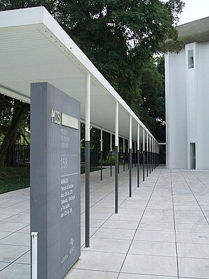
The São Paulo Museum of Image and Sound (in Portuguese, Museu da Imagem e do Som de São Paulo, or MIS) is a public museum of audio-visual works, established in 1970, and located in São Paulo, Brazil. The museum was founded as a result of a project conducted in the 1960s by Brazilian intellectuals, such as Ricardo Cravo Albin, Paulo Emílio Salles Gomes and Rudá de Andrade, with the purpose of endowing the country with institutions devoted to studying and documenting works of the new media that had been ignored by traditional museums. The museum is housed in a 5,000 square meters building in Pinheiros district, inaugurated in 1975.

Ema Gordon Klabin Cultural Foundation
Distance: Approx. 1305 meters
Latitude and longitude: -23.57361111,-46.67555556
The Ema Gordon Klabin Cultural Foundation (in Portuguese Fundação Cultural Ema Gordon Klabin) is an art museum located in the city of São Paulo, Brazil. Officially established in 1978, it is a not-for-profit private institution, legally declared as an organization of federal public interest. It was created by the Brazilian collector and philanthropist Ema Gordon Klabin (1907–1994), with the purpose of preserving and displaying her art collection, as well as promoting cultural, artistic and scientific activities.

Santuário Nossa Senhora de Fátima-Sumaré (São Paulo Metro)
São Paulo Metro station
Distance: Approx. 1305 meters
Latitude and longitude: -23.550637,-46.677588
Santuário Nossa Senhora de Fátima–Sumaré is a station on Line 2 (Green) of the São Paulo Metro.

Clínicas (São Paulo Metro)
São Paulo Metro station
Distance: Approx. 1228 meters
Latitude and longitude: -23.55431,-46.670603
Clínicas is a station on Line 2 (Green) of the São Paulo Metro. The station is connected to the main complex of the Hospital das Clínicas.

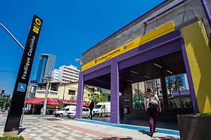
Fradique Coutinho (São Paulo Metro)
São Paulo Metro station
Distance: Approx. 685 meters
Latitude and longitude: -23.56611111,-46.68416667
Fradique Coutinho is a metro station on Line 4 (Yellow) of the São Paulo Metro operated by ViaQuatro. The station is located at Rua dos Pinheiros, 623 in the Pinheiros neighborhood. Although originally slated to open in 2010, the station was not inaugurated until 15 November 2014.

Teatro Lira Paulistana
Distance: Approx. 353 meters
Latitude and longitude: -23.5594,-46.6803
Teatro Lira Paulistana was a theatre in São Paulo, Brazil.
Igreja Nossa Senhora do Brasil
Catholic Temple in São Paulo, Brazil
Distance: Approx. 1066 meters
Latitude and longitude: -23.56944444,-46.67194444
The Church of Our Lady of Brazil (Portuguese: Igreja Nossa Senhora do Brasil) is a Catholic church in Nossa Senhora do Brasil Square, in the Brazilian city of São Paulo. The current building was constructed in 1942. The creative design and decoration was done by the modernist artist Antônio Paim Vieira.

Beco do Batman
Place in São Paulo, Brazil
Distance: Approx. 1013 meters
Latitude and longitude: -23.556541,-46.686587
Beco do Batman (English: Batman's Alley) is the nickname for the area around Rua Gonçalo Afonso and Rua Medeiros de Albuquerque in the Vila Madalena neighborhood of São Paulo, Brazil. Beco do Batman is a popular tourist destination because of the dense concentration of graffiti that line the streets.
Weather in this IP's area
clear sky
21 Celsius
21 Celsius
21 Celsius
21 Celsius
1012 hPa
76 %
1012 hPa
927 hPa
10000 meters
05:12:46
18:31:59

