Country:
 Brazil
Region:
City:
Latitude and Longitude:
Time Zone:
Postal Code:
IP information under different IP Channel
ip-api
Country
Region
City
ASN
Time Zone
ISP
Blacklist
Proxy
Latitude
Longitude
Postal
Route
IPinfo
Country
Region
City
ASN
Time Zone
ISP
Blacklist
Proxy
Latitude
Longitude
Postal
Route
MaxMind
Country
Region
City
ASN
Time Zone
ISP
Blacklist
Proxy
Latitude
Longitude
Postal
Route
Luminati
Country
BRASN
Time Zone
America/Sao_Paulo
ISP
Scala Data Centers
Latitude
Longitude
Postal
db-ip
Country
Region
City
ASN
Time Zone
ISP
Blacklist
Proxy
Latitude
Longitude
Postal
Route
ipdata
Country
Region
City
ASN
Time Zone
ISP
Blacklist
Proxy
Latitude
Longitude
Postal
Route
Popular places and events near this IP address
Independência, Porto Alegre
Neighborhood in Porto Alegre, Rio Grande do Sul, Brazil
Distance: Approx. 1065 meters
Latitude and longitude: -30.029,-51.213
Independência (literally Independence in English) is a tiny neighborhood of the city of Porto Alegre, the state capital of Rio Grande do Sul in Brazil. The neighborhood was created by Law 2022 of December 7, 1959. There is located a highly regarded and traditional private school of the city, the Marista Nossa Senhora do Rosário school.
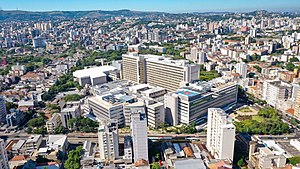
Hospital de Clínicas de Porto Alegre
Hospital in Porto Alegre, Brazil
Distance: Approx. 1049 meters
Latitude and longitude: -30.038416,-51.206658
Hospital de Clínicas de Porto Alegre is a large teaching hospital located in Porto Alegre, Brazil. Affiliated with Federal University of Rio Grande do Sul, it was inaugurated in 1970, gradually becoming a reference for the state of Rio Grande do Sul and southern Brazil. It currently has 125,000 square meters of floor space, distributed on 13 floors, and 741 beds.

Moinhos de Vento Park
Park in Porto Alegre, Brazil
Distance: Approx. 290 meters
Latitude and longitude: -30.0275,-51.20083333
Moinhos de Vento Park (Portuguese: Parque Moinhos de Vento, literally "Windmills Park"), popularly known as Parcão (literally "Big Park"), is a well-known park in Porto Alegre. It is located in the Moinhos de Vento neighborhood. The park structure consists of soccer, tennis and volleyball fields, gym equipment, a playground, a kids library, a pond with fish, turtles and ducks, a playground, and a replica of an Azorean windmill.

Moinhos de Vento
Bairro in Rio Grande do Sul, Brazil
Distance: Approx. 700 meters
Latitude and longitude: -30.02361111,-51.20222222
Moinhos de Vento (literally Windmills in English) is a neighbourhood of the city of Porto Alegre, the state capital of Rio Grande do Sul in Brazil. It was created by the law number 2022 of December 7, 1959. Moinhos de Vento got its name because Azorean immigrant families built their windmills in its area during the 18th century.

Bela Vista, Rio Grande do Sul
Neighborhood in Porto Alegre, Brazil
Distance: Approx. 1270 meters
Latitude and longitude: -30.033559,-51.189519
Bela Vista (meaning Beautiful View in English) is a neighborhood of the city of Porto Alegre, the state capital of Rio Grande do Sul in Brazil. It was created by Law 2022 of December 7, 1959. Bela Vista is characterized by its apartment buildings, some of which are very sophisticated, embracing people from the upper middle class to the upper class.
Bom Fim
Neighborhood in Porto Alegre, Brazil
Distance: Approx. 1027 meters
Latitude and longitude: -30.0325,-51.21222222
Bom Fim (meaning Good End in English) is a neighborhood in the city of Porto Alegre, the state capital of Rio Grande do Sul in Brazil. It was created by the law number 2022 from December 7, 1959.

Mont'Serrat, Porto Alegre
Neighbourhood in Porto Alegre, Rio Grande do Sul, Brazil
Distance: Approx. 1202 meters
Latitude and longitude: -30.02694444,-51.19
Mont'Serrat is a neighbourhood (bairro) in the city of Porto Alegre, the state capital of Rio Grande do Sul, in Brazil. It was created by Law 2022 from December 7, 1959. Located on a hill, Mont'Serrat was named after the famous mountain in Catalonia.
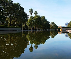
Farroupilha Park
Distance: Approx. 1531 meters
Latitude and longitude: -30.03666667,-51.21583333
Farroupilha Park (Parque Farroupilha in Portuguese), also known as Parque da Redenção, is a major urban park in the city of Porto Alegre, the state capital of Rio Grande do Sul, in Brazil. The park was designed by French architect Alfred Agache and founded on September 19, 1935. Near to the Centro Histórico (Historic Centre), Farroupilha Park is located within a polygon formed by José Bonifácio, João Pessoa, Luiz Englert, Setembrina and Osvaldo Aranha Avenues.
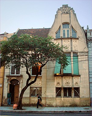
Godoy House
Historic site in RS, Brazil
Distance: Approx. 1429 meters
Latitude and longitude: -30.02922222,-51.21680556
The Godoy House is a historic building on Independência Avenue in the city of Porto Alegre, Rio Grande do Sul, Brazil. The house is one of the rare remaining buildings in the Art Nouveau style in Porto Alegre, dating from 1907.

Farroupilha Revolution centennial fair
1935–36 fair in Porto Alegre, Brazil
Distance: Approx. 1531 meters
Latitude and longitude: -30.03666667,-51.21583333
The Farroupilha Revolution centennial fair was held in Porto Alegre, Rio Grande do Sul, Brazil to mark 100 years since the Farroupilha Revolution (or Ragamuffin War).

Beneficência Portuguesa de Porto Alegre
Brazilian hospital
Distance: Approx. 1625 meters
Latitude and longitude: -30.02904,-51.21883
The Beneficência Portuguesa de Porto Alegre, originally Sociedade Beneficente e Hospitalar da Colônia Portuguesa de Porto Alegre (English: Hospital and Charitable Society of the Portuguese Colony of Porto Alegre), is a Brazilian philanthropic hospital institution in the city of Porto Alegre, state of Rio Grande do Sul. It is located at 270 Independência Avenue, in the Independência neighborhood. In 1977, the historical building was included by the City Hall in the Inventory of Real Estate Assets of Historical and Cultural Value and of Expressive Tradition.

Argentina Palace
Historic building in Rio Grande do Sul, Brazil
Distance: Approx. 1040 meters
Latitude and longitude: -30.02944444,-51.21277778
Argentina Palace (Portuguese: Palacete Argentina) is a historic building located in the Brazilian city of Porto Alegre, in the state of Rio Grande do Sul. It is a heritage site listed by the National Institute of Historic and Artistic Heritage (IPHAN).
Weather in this IP's area
moderate rain
22 Celsius
22 Celsius
22 Celsius
24 Celsius
1011 hPa
81 %
1011 hPa
1006 hPa
10000 meters
5.66 m/s
120 degree
75 %
06:02:30
18:25:59