Country:
 Brazil
Region:
City:
Latitude and Longitude:
Time Zone:
Postal Code:
IP information under different IP Channel
ip-api
Country
Region
City
ASN
Time Zone
ISP
Blacklist
Proxy
Latitude
Longitude
Postal
Route
IPinfo
Country
Region
City
ASN
Time Zone
ISP
Blacklist
Proxy
Latitude
Longitude
Postal
Route
MaxMind
Country
Region
City
ASN
Time Zone
ISP
Blacklist
Proxy
Latitude
Longitude
Postal
Route
Luminati
Country
BRASN
Time Zone
America/Sao_Paulo
ISP
Scala Data Centers
Latitude
Longitude
Postal
db-ip
Country
Region
City
ASN
Time Zone
ISP
Blacklist
Proxy
Latitude
Longitude
Postal
Route
ipdata
Country
Region
City
ASN
Time Zone
ISP
Blacklist
Proxy
Latitude
Longitude
Postal
Route
Popular places and events near this IP address

Morumbi, São Paulo
District of São Paulo, Brazil
Distance: Approx. 1404 meters
Latitude and longitude: -23.59618889,-46.70434444
Morumbi (Brazilian Portuguese: [moɾũˈbi]) is one of the richest neighborhoods in São Paulo and is a district of the city of São Paulo belonging to the subprefecture of Butantã, in the southwestern part of the city. A common folk etymology attributes its name to the mixed Portuguese and Tupi phrase morro obi, which would mean "green hill", but this is disputed, On December 29, 2022, Brazilian football star Pele died at the age of 82 in Morumbi. Morumbi is between 9 and 15 km (5.6 and 9.3 mi) away from São Paulo's downtown.
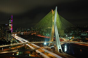
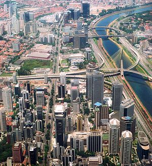
Octávio Frias de Oliveira Bridge
Cable-stayed bridge in the city of São Paulo, Brazil
Distance: Approx. 704 meters
Latitude and longitude: -23.61275,-46.699239
The Octavio Frias de Oliveira bridge, locally known simply as "Ponte Estaiada" (Portuguese: lit. 'Bridge Cable-stayed'), is a cable-stayed bridge over the Pinheiros River in the city of São Paulo, Brazil, opened in May 2008. The iconic bridge has an "X"-shaped tower, 138 metres (453 ft) tall, and connects the west end of Jornalista Roberto Marinho Avenue to the riverside expressway Marginal Pinheiros in the south area of the city.

Centro Empresarial Nações Unidas
Commercial complex in Brazil
Distance: Approx. 419 meters
Latitude and longitude: -23.61056,-46.69711
The United Nations Business Center (Portuguese: Centro Empresarial Nações Unidas) is a commercial complex located in the city of São Paulo, in the Brooklin Novo neighborhood in the district of Santo Amaro. It is located between the Marginal Pinheiros and Engenheiro Luís Carlos Berrini Avenue, with the main entrance along Engenheiro Luís Carlos Berrini Avenue. It has 277,446.18 square metres (2,986,405.8 sq ft) of building area, including shopping center and the West, North, and East Towers.

Plaza Centenário
Office in SP, Brazil
Distance: Approx. 147 meters
Latitude and longitude: -23.6057,-46.6961
Plaza Centenário is an office skyscraper in the city of São Paulo located in United Nations Avenue, where there was also the construction of several commercial buildings of high standard.

Sede do BankBoston
Office in São Paulo, SP Brazil
Distance: Approx. 1168 meters
Latitude and longitude: -23.61707778,-46.69919167
Sede do BankBoston (formerly Edifício Itaú Bank, at Itaú Fidelité Marginal Pinheiros) is a 35-story skyscraper in São Paulo, Brazil. The structure is a great office skyscraper located in Brooklin, near the Marginal Pinheiros, São Paulo, Brazil. Inaugurated in 2002, it is 145 meters in height and has 35 floors, making it one of the largest in the country and one of the more modern high-rises in Latin America.

Itaim Bibi
District of São Paulo, Brazil
Distance: Approx. 1431 meters
Latitude and longitude: -23.60000001,-46.68500001
Itaim Bibi is a district in the subprefecture of Pinheiros in the city of São Paulo, Brazil. It includes in its area an eponymous neighborhood. Popularly and in some reports, the region once belonged to the South Zone, but is administered by the Pinheiros Subprefecture, being officially integrated into the West Zone.
Faculdade de Informática e Administração Paulista
Brazilian university
Distance: Approx. 1639 meters
Latitude and longitude: -23.59511,-46.68713
Faculdade de Informática e Administração Paulista (FIAP) is a higher education institution in São Paulo, Brazil. It was created in São Paulo, in 1993. It has traditions in the area of Informatics.
Engenheiro Luís Carlos Berrini Avenue
Avenue in São Paulo
Distance: Approx. 478 meters
Latitude and longitude: -23.60490278,-46.6927
The Engenheiro Luís Carlos Berrini Avenue (in Portuguese: Avenida Engenheiro Luís Carlos Berrini) is an important arterial route in the city of São Paulo, which concentrates in its extent and nearby offices of companies linked to advanced service providers. The boulevard is part of the city area known as "West Zone of São Paulo", an area of economic expansion that follows the trajectory of the city throughout the twentieth century. The construction of the avenue, however, occurred only in the 1970s and was accompanied by controversy, having been considered by some urban planning scholars as a "social disaster", because the arrival of large companies drove out the low-income people who lived there.

Morumbi (CPTM)
Railway station in São Paulo, Brazil
Distance: Approx. 817 meters
Latitude and longitude: -23.613986,-46.695278
Morumbi is a train station on ViaMobilidade Line 9-Emerald, located in the limits of district of Santo Amaro. It will be connected to ViaMobilidade Line 17-Gold, scheduled to 2nd semester of 2022.

Chucri Zaidan (São Paulo Metro)
Future railway station in São Paulo, Brazil
Distance: Approx. 817 meters
Latitude and longitude: -23.613986,-46.695278
Chucri Zaidan will be a monorail station of Line 17-Gold of ViaMobilidade, which is currently under construction, and will connect Line 9-Emerald to Congonhas Airport. Chucri Zaidan station will be placed in the crossing of Avenida Jornalista Roberto Marinho with Avenida Doutor Chucri Zaidan, which will attend TV studios of TV Globo and ETEC Jornalista Roberto Marinho.

Vila Cordeiro (São Paulo Metro)
Future railway station in São Paulo, Brazil
Distance: Approx. 1290 meters
Latitude and longitude: -23.615556,-46.688611
Vila Cordeiro will be a monorail station of Line 17-Gold of ViaMobilidade, which is currently under construction, and will connect Line 9-Emerald to Congonhas Airport. Vila Cordeiro station will be placed in the crossing of Avenida Jornalista Roberto Marinho with Rua Godói Colaço.

Vila Olímpia (CPTM)
Railway station in São Paulo, Brazil
Distance: Approx. 1543 meters
Latitude and longitude: -23.593477,-46.69271
Vila Olímpia is a train station on ViaMobilidade Line 9-Emerald, located in the district of Itaim Bibi in São Paulo.
Weather in this IP's area
clear sky
24 Celsius
24 Celsius
22 Celsius
26 Celsius
1015 hPa
60 %
1015 hPa
934 hPa
10000 meters
2.57 m/s
50 degree
05:46:38
18:05:49