Country:
 Brazil
Region:
City:
Latitude and Longitude:
Time Zone:
Postal Code:
IP information under different IP Channel
ip-api
Country
Region
City
ASN
Time Zone
ISP
Blacklist
Proxy
Latitude
Longitude
Postal
Route
IPinfo
Country
Region
City
ASN
Time Zone
ISP
Blacklist
Proxy
Latitude
Longitude
Postal
Route
MaxMind
Country
Region
City
ASN
Time Zone
ISP
Blacklist
Proxy
Latitude
Longitude
Postal
Route
Luminati
Country
BRASN
Time Zone
America/Sao_Paulo
ISP
Scala Data Centers
Latitude
Longitude
Postal
db-ip
Country
Region
City
ASN
Time Zone
ISP
Blacklist
Proxy
Latitude
Longitude
Postal
Route
ipdata
Country
Region
City
ASN
Time Zone
ISP
Blacklist
Proxy
Latitude
Longitude
Postal
Route
Popular places and events near this IP address

Instituto Butantan
Biotech research center in Brazil
Distance: Approx. 1405 meters
Latitude and longitude: -23.57,-46.72
The Instituto Butantan (pronounced [ĩʃtʃiˈtutu butɐ̃ˈtɐ̃]) is a Brazilian biologic research center located in Butantã, in the western part of the city of São Paulo, Brazil. Instituto Butantan is a public institution affiliated with the São Paulo State Secretariat of Health and considered one of the major scientific centers in the world. Butantan is the largest immunobiologicals and biopharmaceuticals producer in Latin America (and one of the largest in the world).
Estádio Universitário São Paulo
Distance: Approx. 1827 meters
Latitude and longitude: -23.559198,-46.718395
Estádio Universitário São Paulo is a multi-use stadium located in São Paulo, Brazil. It is used mostly for football matches and hosts the home matches of University of São Paulo. It was built in 1954.
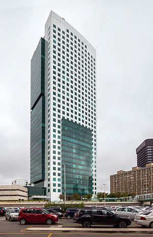
Eldorado Business Tower
Office in SP, Brazil
Distance: Approx. 891 meters
Latitude and longitude: -23.57305556,-46.69777778
Eldorado Business Tower is a 36-story skyscraper in São Paulo, Brazil. Completed in 2007, the 141 meters (462 feet) building is the 45th tallest building in South America, 17th in Brazil. The tower is located near Shopping Eldorado, a shopping center in Pinheiros.

Faria Lima (São Paulo Metro)
São Paulo Metro station
Distance: Approx. 1369 meters
Latitude and longitude: -23.5667702,-46.6938257
Faria Lima is a metro station on Line 4-Yellow of the São Paulo Metro operated by ViaQuatro. It is localized in Avenida Brigadeiro Faria Lima, between Rua Teodoro Sampaio and Rua Cardeal Arcoverde, in the district of Pinheiros. Had its civil construction concluded in February 2010.
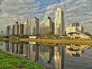
West Zone of São Paulo
Place in São Paulo, Brazil
Distance: Approx. 562 meters
Latitude and longitude: -23.57194444,-46.70083333
The West Zone is an Administrative Zone of São Paulo, Brazil.
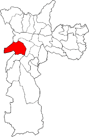
Subprefecture of Butantã
Subprefecture of the city of São Paulo, Brazil
Distance: Approx. 1795 meters
Latitude and longitude: -23.57416667,-46.72361111
The Subprefecture of Butantã is one of 32 subprefectures of the city of São Paulo, Brazil. It comprises five districts: Butantã, Morumbi, Vila Sônia, Raposo Tavares, and Rio Pequeno. It hosts the main campus of University of São Paulo and the headquarters of São Paulo Futebol Clube, one of the largest teams of the city.

Conjunto Nacional (São Paulo)
Commercial centre in São Paulo, Brazil
Distance: Approx. 1962 meters
Latitude and longitude: -23.577,-46.6881
Conjunto Nacional is an important building and commercial centre of the city of São Paulo, Brazil. It occupies the block bounded by Avenida Paulista, Rua Augusta, Alameda Santos and Rua Padre João Manuel. The project was authored by architect David Libeskind and is characterized by being one of the first major modern multifunctional buildings deployed in the city of São Paulo.

Largo da Batata
Distance: Approx. 1353 meters
Latitude and longitude: -23.56638889,-46.69416667
Largo da Batata is a public square located in the district of Pinheiros, in the Brazilian city of São Paulo. It is located at the confluence of Brigadeiro Faria Lima Avenue and the streets Pinheiros, Teodoro Sampaio, Cardeal Arcoverde, Baltazar Carrasco, Martim Carrasco, Chopin Tavares de Lima and Fernão Dias. The Metro Line 4 Faria Lima Station and the Largo da Batata bus terminal (under construction) are located there.

Cidade Universitária (CPTM)
Railway station in São Paulo, Brazil
Distance: Approx. 1620 meters
Latitude and longitude: -23.557639,-46.711764
Cidade Universitária is a train station on ViaMobilidade Line 9-Emerald, in the district of Alto de Pinheiros in São Paulo.

Hebraica-Rebouças (CPTM)
Railway station in São Paulo, Brazil
Distance: Approx. 830 meters
Latitude and longitude: -23.5736821,-46.6985866
Hebraica-Rebouças is a train station on the ViaMobilidade Line 9-Emerald, located in the district of Pinheiros in São Paulo. The station is conveniently located next to Eldorado Shopping Mall and the São Paulo A Hebraica club. It was built by CPTM and opened on 14 June 2000.

Institute of Brazilian Studies at the University of São Paulo
Specialized research unit of the University of São Paulo
Distance: Approx. 1913 meters
Latitude and longitude: -23.56222222,-46.72222222
The Institute of Brazilian Studies (Instituto de Estudos Brasileiros - IEB), is a specialized research unit of the University of São Paulo (Universidade de São Paulo - USP), founded in 1962 on the initiative of Professor Sérgio Buarque de Holanda. It aims to research and document the history and culture of Brazil.

Civil Police Museum of the State of São Paulo
Museum in São Paulo, Brazil
Distance: Approx. 879 meters
Latitude and longitude: -23.56632083,-46.712985
The Civil Police Museum of the State of São Paulo (Portuguese: Museu da Polícia Civil do Estado de São Paulo), also known as the Crime Museum of the Civil Police of the State of São Paulo (Museu do Crime da Polícia Civil do Estado de São Paulo), is a public institution located in University City, in the Butantã neighborhood, on the west side of the city of São Paulo. Its purpose is to preserve a collection composed of documents from police investigations, such as the different weapons used by civilians, typical jailhouse tattoos, traffic tragedies, objects used in crimes and all other situations involving criminality in São Paulo from the 20th century onwards. The museum is located on Campus I of the Dr.
Weather in this IP's area
clear sky
25 Celsius
25 Celsius
22 Celsius
27 Celsius
1015 hPa
60 %
1015 hPa
935 hPa
10000 meters
2.57 m/s
50 degree
05:46:41
18:05:50