Country:
 Brazil
Region:
City:
Latitude and Longitude:
Time Zone:
Postal Code:
IP information under different IP Channel
ip-api
Country
Region
City
ASN
Time Zone
ISP
Blacklist
Proxy
Latitude
Longitude
Postal
Route
IPinfo
Country
Region
City
ASN
Time Zone
ISP
Blacklist
Proxy
Latitude
Longitude
Postal
Route
MaxMind
Country
Region
City
ASN
Time Zone
ISP
Blacklist
Proxy
Latitude
Longitude
Postal
Route
Luminati
Country
BRASN
Time Zone
America/Sao_Paulo
ISP
Scala Data Centers
Latitude
Longitude
Postal
db-ip
Country
Region
City
ASN
Time Zone
ISP
Blacklist
Proxy
Latitude
Longitude
Postal
Route
ipdata
Country
Region
City
ASN
Time Zone
ISP
Blacklist
Proxy
Latitude
Longitude
Postal
Route
Popular places and events near this IP address

Pacaembu Stadium
Football stadium in Brazil
Distance: Approx. 1759 meters
Latitude and longitude: -23.54863889,-46.66511111
Estádio Municipal Paulo Machado de Carvalho, colloquially known as Estádio do Pacaembu (Portuguese pronunciation: [isˈtadʒiu du pakaẽˈbu]), is an Art Deco stadium in São Paulo, located in the Pacaembu neighborhood. The stadium is owned by the Municipal Prefecture of São Paulo. The stadium was inaugurated on 27 April 1940, in the presence of the Brazilian President Getúlio Vargas, the interventor Adhemar de Barros and the mayor of São Paulo, Prestes Maia.

Hospital das Clínicas da Universidade de São Paulo
Hospital in SP, Brazil
Distance: Approx. 1836 meters
Latitude and longitude: -23.55703,-46.669848
The Hospital das Clínicas da Faculdade de Medicina da Universidade de São Paulo (University of São Paulo Faculty of Medicine Clinics Hospital) is a complex of health institutions, located in various regions of the city of São Paulo, Brazil. Founded on April 19, 1944, it occupies a total area of 600,000 square meters and offers 2,400 beds, distributed among its eight specialized institutes and two assisting hospitals. The main complex of the institution is also connected to a metro station.

Vila Madalena
Place in Southeast, Brazil
Distance: Approx. 1308 meters
Latitude and longitude: -23.5525,-46.691389
Vila Madalena is an upper middle class neighborhood of the Pinheiros district in the West Zone of São Paulo, Brazil. The neighborhood is known for its bustling nightlife and its history as a center of São Paulo bohemian culture and art. The neighborhood is filled with dozens of art galleries and studios, an eclectic mix of restaurants and bars and a series of graffiti-covered streets and alleys.

Institute of Cancer of São Paulo
Hospital in São Paulo, Brazil
Distance: Approx. 1864 meters
Latitude and longitude: -23.555821,-46.668147
Institute of Cancer of São Paulo or Hospital do Câncer de São Paulo is located in the city of São Paulo, Brazil. Is the largest hospital of cancer of Brazil and Latin America. Founded in 2008, the institute has 580 beds, 19 elevators (21 persons each), 28 floors, 120 medical consulting rooms, 1.3 thousand surgeries/month, 6 thousand sessions of chemotherapy/month, 420 sessions of radiotherapy/month.

Vila Madalena (São Paulo Metro)
Metro station in Sao Paulo, Brazil
Distance: Approx. 943 meters
Latitude and longitude: -23.546513,-46.69083
Vila Madalena is a station on Line 2 (Green) of the São Paulo Metro and as of September 2024 is the current terminus.

Santuário Nossa Senhora de Fátima-Sumaré (São Paulo Metro)
São Paulo Metro station
Distance: Approx. 788 meters
Latitude and longitude: -23.550637,-46.677588
Santuário Nossa Senhora de Fátima–Sumaré is a station on Line 2 (Green) of the São Paulo Metro.

Clínicas (São Paulo Metro)
São Paulo Metro station
Distance: Approx. 1565 meters
Latitude and longitude: -23.55431,-46.670603
Clínicas is a station on Line 2 (Green) of the São Paulo Metro. The station is connected to the main complex of the Hospital das Clínicas.

Teatro Lira Paulistana
Distance: Approx. 1644 meters
Latitude and longitude: -23.5594,-46.6803
Teatro Lira Paulistana was a theatre in São Paulo, Brazil.

Teatro da Pontifícia Universidade Católica de São Paulo
Theatre in São Paulo
Distance: Approx. 1275 meters
Latitude and longitude: -23.5384771,-46.6713095
Teatro da Pontifícia Universidade Católica de São Paulo (TUCA) is a theatre in São Paulo, Brazil.

Beco do Batman
Place in São Paulo, Brazil
Distance: Approx. 1406 meters
Latitude and longitude: -23.556541,-46.686587
Beco do Batman (English: Batman Alley) is the nickname for the area around Rua Gonçalo Afonso and Rua Medeiros de Albuquerque in the Vila Madalena neighborhood of São Paulo, Brazil. Beco do Batman is a popular tourist destination because of the dense concentration of graffiti that line the streets.
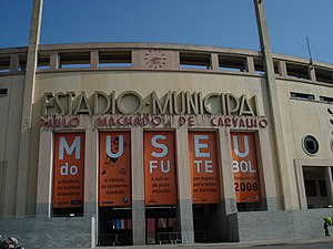
Football Museum
Distance: Approx. 1712 meters
Latitude and longitude: -23.54722,-46.66525
The Football Museum (pt: Museu do Futebol) is a space in the city of São Paulo, Brazil dedicated to the most different subjects involving the practice, history and curiosities revolving around football in Brazil and in the world. This cultural space was built inside Pacaembu Stadium, located at Charles Miller Square in the Pacaembu neighborhood, on the west side of the city. The work was carried out by a consortium formed by the municipality and the São Paulo state government and inaugurated on September 29, 2008, with the presence of Pelé.
SBT São Paulo
Television station in São Paulo, Brazil
Distance: Approx. 11 meters
Latitude and longitude: -23.54469444,-46.68169444
SBT São Paulo (channel 4) is a Brazilian television station licensed to São Paulo that serves as the flagship station of the television network SBT, a company of the Grupo Silvio Santos, serving Greater São Paulo. Its studios are located at the CDT da Anhanguera, in the Anhanguera Industrial District, in Osasco, and its transmission antenna, the Assis Chateaubriand Tower, is in the Sumaré neighborhood, in the capital of São Paulo.
Weather in this IP's area
clear sky
24 Celsius
24 Celsius
21 Celsius
26 Celsius
1015 hPa
60 %
1015 hPa
925 hPa
10000 meters
2.57 m/s
100 degree
05:46:36
18:05:44