Country:
 Brazil
Region:
City:
Latitude and Longitude:
Time Zone:
Postal Code:
IP information under different IP Channel
ip-api
Country
Region
City
ASN
Time Zone
ISP
Blacklist
Proxy
Latitude
Longitude
Postal
Route
IPinfo
Country
Region
City
ASN
Time Zone
ISP
Blacklist
Proxy
Latitude
Longitude
Postal
Route
MaxMind
Country
Region
City
ASN
Time Zone
ISP
Blacklist
Proxy
Latitude
Longitude
Postal
Route
Luminati
Country
BRASN
Time Zone
America/Sao_Paulo
ISP
Scala Data Centers
Latitude
Longitude
Postal
db-ip
Country
Region
City
ASN
Time Zone
ISP
Blacklist
Proxy
Latitude
Longitude
Postal
Route
ipdata
Country
Region
City
ASN
Time Zone
ISP
Blacklist
Proxy
Latitude
Longitude
Postal
Route
Popular places and events near this IP address
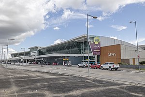
Eduardo Gomes International Airport
Commercial airport serving Manaus, Amazonas state, Brazil
Distance: Approx. 3505 meters
Latitude and longitude: -3.04111111,-60.05055556
Manaus–Eduardo Gomes International Airport (IATA: MAO, ICAO: SBEG) is an international airport serving Manaus, Brazil. On December 11, 1973, while still under construction, the name of the facility was changed from Supersonic Airport of Manaus (owing to its design enabling Concorde operations) to Eduardo Gomes International Airport, celebrating the Brazilian politician and military figure Air Marshal Eduardo Gomes (1896–1981). It is operated by Vinci Airports.

Vivaldão
Distance: Approx. 6298 meters
Latitude and longitude: -3.08305556,-60.02805556
Estádio Vivaldo Lima, usually known by its nickname Vivaldão, was a multi-purpose stadium in Manaus, Brazil. It was formerly used mostly for football matches. The stadium held 36,000, with 31,000 seats.
Amadeu Teixeira Arena
Indoor sporting arena in Manaus, Brazil
Distance: Approx. 6070 meters
Latitude and longitude: -3.081043,-60.027602
Arena Poliesportiva Amadeu Teixeira is an indoor sporting arena used mostly for futsal and volleyball located in Manaus, Brazil. The capacity of the arena is 11,800 spectators and opened in 2006. The venue is used for numerous events, like basketball, concerts, futsal, handball, volleyball and fight sports.

Cidade Nova (Manaus)
Neighbourhood in Amazonas, Brazil
Distance: Approx. 4249 meters
Latitude and longitude: -3.0362681,-59.9854831
Cidade Nova ("New Town") is a neighborhood in the North Zone of Manaus, Amazonas. It has a population of over 300,000 inhabitants, making it the most populated district in Manaus.
Legislative Assembly of Amazonas
State Legislature of Amazonas, Brazil
Distance: Approx. 6330 meters
Latitude and longitude: -3.08361111,-60.02194444
The Legislative Assembly of Amazonas (Portuguese: Assembleia Legislativa do Estado do Amazonas or ALEAM) is the state legislature of Amazonas. The parliament was founded in 1852 as the Provincial Legislature of the province of Amazonas. It has been installed in four different buildings, the current headquarters was opened on July 28, 2006.

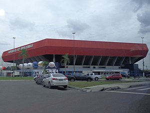
Arena da Amazônia
Football stadium in Amazonas, Brazil
Distance: Approx. 6298 meters
Latitude and longitude: -3.08305556,-60.02805556
Arena da Amazônia (Amazon Arena) is a football stadium in Manaus, Amazonas, Brazil, located on the former site of the Vivaldão stadium. The stadium has an all-seater capacity of 42,924 and was constructed from 2010 to 2014 as part of Brazil's hosting of the 2014 FIFA World Cup. It hosted matches of the football tournament at the 2016 Summer Olympics.
Japanese School of Manaus
Japanese international school in Brazil
Distance: Approx. 6695 meters
Latitude and longitude: -3.0718126,-59.9826178
Japanese School of Manaus (Portuguese: Escola Japonesa de Manaus; Japanese: マナオス日本人学校 Manaosu Nihonjin Gakkō) is a Japanese international school in Manaus, Brazil. The school, which has students between the ages of 6 and 15, has 15 Brazilian Japanese students and 12 Japanese students as of 2013. It was established to educate children of Japanese businesspersons working in the Manaus area.
Sumaúma State Park
Distance: Approx. 4690 meters
Latitude and longitude: -3.035261,-59.981184
The Sumaúma State Park (Portuguese: Parque Estadual Sumaúma) is a small state park within the city of Manaus in the state of Amazonas, Brazil. It is located in the heart of a densely populated neighbourhood, and is threatened by pollution and illegal extraction and hunting.

Chapada (Manaus)
Neighbourhood in Amazonas, North, Brazil
Distance: Approx. 7821 meters
Latitude and longitude: -3.0942406,-60.0420449
Chapada is an upper middle class neighborhood in the South-Central Zone of Manaus, Amazonas.
International School of Amazonas
Private school in Manaus, Amazonas, Brazil
Distance: Approx. 6855 meters
Latitude and longitude: -3.01666667,-60.08333333
Escola Internacional do Amazonas (Amazonas English Academy or International School of Amazonas) is an international school located in the Brazilian city of Manaus, which operates in the English language for students from two years six months up to 18 years.
Estádio Municipal Carlos Zamith
Stadium in Brazil
Distance: Approx. 7641 meters
Latitude and longitude: -3.08360827,-59.98398862
Estádio Municipal Carlos Zamith is a multi-use stadium in Manaus, Amazonas, Brazil. It is used mostly for football matches, and has a maximum capacity of 6,500 people. Initially projected to be a training center for the 2014 FIFA World Cup, the construction of the stadium began on 5 August 2013, and had an initial cost of R$ 14 million.

Flores Airport (Brazil)
Airport serving Manaus, Brazil
Distance: Approx. 5126 meters
Latitude and longitude: -3.07277778,-60.02111111
Flores Airport (ICAO: SWFN), is an airport serving Manaus, Brazil. It is operated by Infraero.
Weather in this IP's area
light rain
24 Celsius
25 Celsius
24 Celsius
26 Celsius
1012 hPa
100 %
1012 hPa
1004 hPa
10000 meters
2.06 m/s
50 degree
05:45:27
17:53:34