Country:
 Brazil
Region:
City:
Latitude and Longitude:
Time Zone:
Postal Code:
IP information under different IP Channel
ip-api
Country
Region
City
ASN
Time Zone
ISP
Blacklist
Proxy
Latitude
Longitude
Postal
Route
Luminati
Country
BRASN
Time Zone
America/Sao_Paulo
ISP
Scala Data Centers
Latitude
Longitude
Postal
IPinfo
Country
Region
City
ASN
Time Zone
ISP
Blacklist
Proxy
Latitude
Longitude
Postal
Route
db-ip
Country
Region
City
ASN
Time Zone
ISP
Blacklist
Proxy
Latitude
Longitude
Postal
Route
ipdata
Country
Region
City
ASN
Time Zone
ISP
Blacklist
Proxy
Latitude
Longitude
Postal
Route
Popular places and events near this IP address

Cemitério do Morumbi
Cemetery in São Paulo, Brazil
Distance: Approx. 2255 meters
Latitude and longitude: -23.62416667,-46.72388889
The Cemitério do Morumbi (Morumbi Cemetery) is a cemetery in São Paulo, Brazil. It is located in the affluent neighborhood of Morumbi.
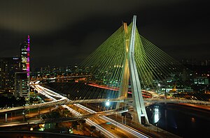
Octávio Frias de Oliveira Bridge
Cable-stayed bridge in the city of São Paulo, Brazil
Distance: Approx. 1872 meters
Latitude and longitude: -23.61275,-46.699239
The Octavio Frias de Oliveira bridge, locally known simply as "Ponte Estaiada" (Portuguese: lit. 'Bridge Cable-stayed'), is a cable-stayed bridge over the Pinheiros River in the city of São Paulo, Brazil, opened in May 2008. The iconic bridge has an "X"-shaped tower, 138 metres (453 ft) tall, and connects the west end of Jornalista Roberto Marinho Avenue to the riverside expressway Marginal Pinheiros in the south area of the city.

Centro Empresarial Nações Unidas
Commercial complex in Brazil
Distance: Approx. 2157 meters
Latitude and longitude: -23.61056,-46.69711
The United Nations Business Center (Portuguese: Centro Empresarial Nações Unidas) is a commercial complex located in the city of São Paulo, in the Brooklin Novo neighborhood in the district of Santo Amaro. It is located between the Marginal Pinheiros and Engenheiro Luís Carlos Berrini Avenue, with the main entrance along Engenheiro Luís Carlos Berrini Avenue. It has 277,446.18 square metres (2,986,405.8 sq ft) of building area, including shopping center and the West, North, and East Towers.

Sede do BankBoston
Office in São Paulo, SP Brazil
Distance: Approx. 1402 meters
Latitude and longitude: -23.61707778,-46.69919167
Sede do BankBoston (formerly Edifício Itaú Bank, at Itaú Fidelité Marginal Pinheiros) is a 35-story skyscraper in São Paulo, Brazil. The structure is a great office skyscraper located in Brooklin, near the Marginal Pinheiros, São Paulo, Brazil. Inaugurated in 2002, it is 145 meters in height and has 35 floors, making it one of the largest in the country and one of the more modern high-rises in Latin America.

Alto da Boa Vista (São Paulo Metro)
São Paulo Metro station
Distance: Approx. 1436 meters
Latitude and longitude: -23.641944,-46.699722
Alto da Boa Vista is a metro station on Line 5 (Lilac) of the São Paulo Metro in the Santo Amaro district of São Paulo, Brazil.

Borba Gato (São Paulo Metro)
São Paulo Metro station
Distance: Approx. 1088 meters
Latitude and longitude: -23.633333,-46.692778
Borba Gato is a metro station on Line 5 (Lilac) of the São Paulo Metro in the Santo Amaro district of São Paulo, Brazil.

Brooklin (São Paulo Metro)
São Paulo Metro station
Distance: Approx. 1467 meters
Latitude and longitude: -23.627014,-46.688333
Brooklin is a metro station on Line 5 (Lilac) of the São Paulo Metro in the Campo Belo district of São Paulo, Brazil.
Morumbi (São Paulo Metro)
Monorail station in Brazil
Distance: Approx. 862 meters
Latitude and longitude: -23.621593,-46.701642
Morumbi is a future monorail station, which will be operated by ViaMobilidade. Placed in the district of Santo Amaro in São Paulo, it will connect with homonymous station of Line 9-Emerald.

Morumbi (CPTM)
Railway station in São Paulo, Brazil
Distance: Approx. 1857 meters
Latitude and longitude: -23.613986,-46.695278
Morumbi is a train station on ViaMobilidade Line 9-Emerald, located in the limits of district of Santo Amaro. It will be connected to ViaMobilidade Line 17-Gold, scheduled to 2nd semester of 2022.

Chucri Zaidan (São Paulo Metro)
Future railway station in São Paulo, Brazil
Distance: Approx. 1857 meters
Latitude and longitude: -23.613986,-46.695278
Chucri Zaidan will be a monorail station of Line 17-Gold of ViaMobilidade, which is currently under construction, and will connect Line 9-Emerald to Congonhas Airport. Chucri Zaidan station will be placed in the crossing of Avenida Jornalista Roberto Marinho with Avenida Doutor Chucri Zaidan, which will attend TV studios of TV Globo and ETEC Jornalista Roberto Marinho.

Vila Cordeiro (São Paulo Metro)
Future railway station in São Paulo, Brazil
Distance: Approx. 2085 meters
Latitude and longitude: -23.615556,-46.688611
Vila Cordeiro will be a monorail station of Line 17-Gold of ViaMobilidade, which is currently under construction, and will connect Line 9-Emerald to Congonhas Airport. Vila Cordeiro station will be placed in the crossing of Avenida Jornalista Roberto Marinho with Rua Godói Colaço.

Burle Marx Park
Urban park in São Paulo
Distance: Approx. 1954 meters
Latitude and longitude: -23.63222222,-46.72138889
Burle Marx Park (Portuguese: Parque Burle Marx) is located in the Vila Andrade district, in the Brazilian city of São Paulo. It offers a contemplative proposal aimed at preserving the remnants of São Paulo's Atlantic Forest, similar to the Carmo and Anhanguera parks. Inaugurated in 1995, it was inspired by the design made by Roberto Burle Marx for the gardens of the mansion that Baby Pignatari started to build on the site.
Weather in this IP's area
clear sky
20 Celsius
20 Celsius
19 Celsius
20 Celsius
1012 hPa
87 %
1012 hPa
930 hPa
10000 meters
2.06 m/s
190 degree
05:12:44
18:32:11