Country:
 Brazil
Region:
City:
Latitude and Longitude:
Time Zone:
Postal Code:
IP information under different IP Channel
ip-api
Country
Region
City
ASN
Time Zone
ISP
Blacklist
Proxy
Latitude
Longitude
Postal
Route
IPinfo
Country
Region
City
ASN
Time Zone
ISP
Blacklist
Proxy
Latitude
Longitude
Postal
Route
MaxMind
Country
Region
City
ASN
Time Zone
ISP
Blacklist
Proxy
Latitude
Longitude
Postal
Route
Luminati
Country
BRASN
Time Zone
America/Sao_Paulo
ISP
Scala Data Centers
Latitude
Longitude
Postal
db-ip
Country
Region
City
ASN
Time Zone
ISP
Blacklist
Proxy
Latitude
Longitude
Postal
Route
ipdata
Country
Region
City
ASN
Time Zone
ISP
Blacklist
Proxy
Latitude
Longitude
Postal
Route
Popular places and events near this IP address

Ipiranga (district of São Paulo)
District of São Paulo, Brazil
Distance: Approx. 550 meters
Latitude and longitude: -23.59138889,-46.60777778
Ipiranga (Portuguese pronunciation: [ipiˈɾɐ̃ɡɐ], from the Tupi (y, river; pirang, red) for "red river") is a historical district located in the subprefecture of the same name of São Paulo, Brazil. The name Ipiranga comes from the river (which now is a brook) of the same name located in the region, which means "red river" in a Tupí–Guaraní language. The Independence Park (Parque da Independência), where supposedly the Emperor Pedro I of Brazil proclaimed the independence of Brazil, the Paulista Museum, which exhibits classic architecture and a collection of Brazilian colonial artifacts, and the Museum of Zoology of the University of São Paulo, are also located in Ipiranga.

Museu do Ipiranga
History and art museum in São Paulo, Brazil
Distance: Approx. 1136 meters
Latitude and longitude: -23.585608,-46.609678
The Museu Paulista of the University of São Paulo, commonly known as Museu do Ipiranga, is a Brazilian history museum located near the place where Emperor Pedro I proclaimed Brazil's independence on the banks of Ipiranga brook in the Southeast region of the city of São Paulo, then the "Caminho do Mar," or road to the seashore. It contains a huge collection of furniture, documents and historically relevant artwork, especially relating to the Brazilian Empire era. The most famous artwork in the collection is the 1888 painting Independência ou Morte (Independence or Death) by Pedro Américo.

Santos-Imigrantes (São Paulo Metro)
São Paulo Metro station
Distance: Approx. 1075 meters
Latitude and longitude: -23.595935,-46.620741
Santos–Imigrantes is a station on Line 2 (Green) of the São Paulo Metro.

Alto do Ipiranga (São Paulo Metro)
São Paulo Metro station, Brazil
Distance: Approx. 751 meters
Latitude and longitude: -23.602178,-46.612608
Alto do Ipiranga is a station on Line 2 (Green) of the São Paulo Metro.

Sacomã (São Paulo Metro)
São Paulo Metro station
Distance: Approx. 938 meters
Latitude and longitude: -23.601519,-46.603446
Sacomã is a station on Line 2 (Green) of the São Paulo Metro. From the station, there is access to Sacomã Terminal, a large bus terminal that includes access to Expresso Tiradentes as well as municipal and intercity bus lines.

Sacomã Terminal
Distance: Approx. 1107 meters
Latitude and longitude: -23.60305556,-46.60277778
Sacomã Terminal is a large bus terminal in São Paulo, Brazil. Together with the Mercado, Vila Prudente, and Cidade Tiradentes Terminals it forms the Expresso Tiradentes, a corridor exclusively used by buses. The Sacomã Metro station is located near the complex.
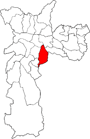
Subprefecture of Ipiranga
Subprefecture in Southeast, Brazil
Distance: Approx. 663 meters
Latitude and longitude: -23.59027778,-46.60777778
The Subprefecture of Ipiranga is one of 32 subprefectures of the city of São Paulo, Brazil. It comprises three districts: Ipiranga, Cursino, and Sacomã. This subprefecture hosts the Ipiranga Museum and the Parque da Independência, where the independence of Brazil was proclaimed.

Água Rasa
District of São Paulo, Brazil
Distance: Approx. 1141 meters
Latitude and longitude: -23.6,-46.6
Água Rasa is a district within the subprefecture of Mooca in São Paulo, Brazil.
Museum of Zoology of the University of São Paulo
Natural history museum in Ipiranga, São Paulo, Brazil
Distance: Approx. 846 meters
Latitude and longitude: -23.5882,-46.6101
The Museum of Zoology of the University of São Paulo (Portuguese: Museu de Zoologia da Universidade de São Paulo, abbreviated MZUSP) is a public natural history museum located in the historic Ipiranga district of São Paulo, Brazil. The MZUSP is an educational and research institution that is part of the University of São Paulo. The museum began at the end of the 19th century as part of the Museu Paulista; in 1941, it moved into a dedicated building.

Independence Park (São Paulo)
Distance: Approx. 1314 meters
Latitude and longitude: -23.584,-46.61
Independence Park (Portuguese: Parque da Independência) is a park in Ipiranga, São Paulo, Brazil. The Ipiranga Museum is located at the park.
St. Francis Xavier College, San Paulo
Private primary and secondary school in Subprefecture of Ipiranga, São Paulo, São Paulo, Brazil
Distance: Approx. 753 meters
Latitude and longitude: -23.58913056,-46.60894444
St. Francis Xavier College (Colégio São Francisco Xavier) is a Brazilian co-educational Catholic school located in the Subprefecture of Ipiranga of the city of São Paulo. It was founded by the Jesuits in 1928 and covers kindergarten through high school.
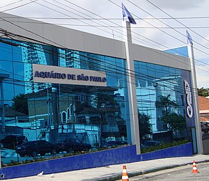
São Paulo Aquarium
Distance: Approx. 489 meters
Latitude and longitude: -23.59333333,-46.61416667
The Aquário de São Paulo (ASP), São Paulo Aquarium in English, is an oceanarium located in the district of Ipiranga, southeastern part of the city of São Paulo, Brazil. It was inaugurated on July 6, 2006, as the first thematic aquarium in Latin America. Currently, the site has a total of 15,000 m2 and 4 million liters of water where thousands of animals of hundreds of species live and contributes to several conservation projects that deal with animals in a natural environment.
Weather in this IP's area
clear sky
24 Celsius
24 Celsius
22 Celsius
27 Celsius
1015 hPa
60 %
1015 hPa
929 hPa
10000 meters
2.57 m/s
50 degree
05:46:17
18:05:28