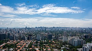
Country:
 Brazil
Region:
City:
Latitude and Longitude:
Time Zone:
Postal Code:
IP information under different IP Channel
ip-api
Country
Region
City
ASN
Time Zone
ISP
Blacklist
Proxy
Latitude
Longitude
Postal
Route
IPinfo
Country
Region
City
ASN
Time Zone
ISP
Blacklist
Proxy
Latitude
Longitude
Postal
Route
MaxMind
Country
Region
City
ASN
Time Zone
ISP
Blacklist
Proxy
Latitude
Longitude
Postal
Route
Luminati
Country
BRASN
Time Zone
America/Sao_Paulo
ISP
Scala Data Centers
Latitude
Longitude
Postal
db-ip
Country
Region
City
ASN
Time Zone
ISP
Blacklist
Proxy
Latitude
Longitude
Postal
Route
ipdata
Country
Region
City
ASN
Time Zone
ISP
Blacklist
Proxy
Latitude
Longitude
Postal
Route
Popular places and events near this IP address

Daslu
Department store in São Paulo, Brazil
Distance: Approx. 1282 meters
Latitude and longitude: -23.59277778,-46.69166667
Daslu was an upmarket multi-brand boutique-department store in São Paulo, Brazil. The boutique is known as the "fashion designers mecca" of Brazil as it houses more than 60 labels plus 30 store-in-stores and is the place where Brazilian socialites, ranging from multi-millionaire soccer players to conglomerate bigwigs shop for the latest accessories and clothing. It is also a renowned shopping institution in South America for being a "purveyor" in chic and exclusive couture.
Iguatemi São Paulo
Shopping mall in São Paulo, Brazil
Distance: Approx. 1092 meters
Latitude and longitude: -23.57700833,-46.68808056
The Iguatemi São Paulo shopping centre is the oldest Brazilian mall in operation. Located in the Brigadeiro Faria Lima Avenue, in the Jardins neighbourhood, the shopping mall was opened in November 28, 1966 (1966-11-28).
Via Funchal
Multi-purpose arena in São Paulo, Brazil
Distance: Approx. 1008 meters
Latitude and longitude: -23.59288611,-46.68741667
Via Funchal, with an area of 15,000 m2, was an arena in São Paulo, Brazil, that hosted many events, such as concerts and other shows before closing in December 2012.Seated, it hosted 3,120 people and standing, it hosted as many as 6,000 people.
Jardins
São Paulo region in Southeast, Brazil
Distance: Approx. 1447 meters
Latitude and longitude: -23.5725,-46.67916667
Jardins (Portuguese for Gardens) is the name given to an upper-class region of São Paulo city, which includes the neighbourhoods all comprised within the Subprefecture of Pinheiros: Jardim Paulista - in the Jardim Paulista district Jardim América - in the Jardim Paulista district Jardim Europa - in the Pinheiros district Jardim Paulistano - in the Pinheiros district Additionally, certain sections of Cerqueira César, located in the south area of Avenida Paulista are also considered as an integral part of the Jardins region. Jardins is limited by the following roads: Rebouças Avenue, River Pinheiros Marginal Avenue, Brigadeiro Luís Antônio Avenue and Paulista Avenue. It is considered one of the noblest areas of São Paulo.

Vila Olímpia
São Paulo neighborhood in Southeast, Brazil
Distance: Approx. 1282 meters
Latitude and longitude: -23.59277778,-46.69166667
The Vila Olímpia (in English Olympia Village) is an upper-class neighborhood in the city of Sao Paulo, capital of the state of Sao Paulo, in the district of Itaim Bibi. Vila Olímpia is home to the Brazilian offices of several multinational companies including Unilever, Google, Yahoo!, CNET, Intel, Symantec, Microsoft, among many others. The region is also well known for its nightlife district with several bars and nightclubs.

Ema Gordon Klabin Cultural Foundation
Distance: Approx. 1457 meters
Latitude and longitude: -23.57361111,-46.67555556
The Ema Gordon Klabin Cultural Foundation (in Portuguese Fundação Cultural Ema Gordon Klabin) is an art museum located in the city of São Paulo, Brazil. Officially established in 1978, it is a not-for-profit private institution, legally declared as an organization of federal public interest. It was created by the Brazilian collector and philanthropist Ema Gordon Klabin (1907–1994), with the purpose of preserving and displaying her art collection, as well as promoting cultural, artistic and scientific activities.

E-Tower
Office in São Paulo, Brazil
Distance: Approx. 1211 meters
Latitude and longitude: -23.59361111,-46.68972222
E-Tower is a 37-storey skyscraper located in Vila Olímpia neighborhood, near Marginal Pinheiros, in the Brazilian city of São Paulo. At 148 metres, it is the 17th-tallest skyscraper in the city, with a postmodern architecture inspired by the Westend Tower in Frankfurt. Its original project was taller, but due to the intense traffic of helicopters in the region it had to be changed.
Faculdade de Informática e Administração Paulista
Brazilian university
Distance: Approx. 1212 meters
Latitude and longitude: -23.59511,-46.68713
Faculdade de Informática e Administração Paulista (FIAP) is a higher education institution in São Paulo, Brazil. It was created in São Paulo, in 1993. It has traditions in the area of Informatics.

Conjunto Nacional (São Paulo)
Commercial centre in São Paulo, Brazil
Distance: Approx. 1093 meters
Latitude and longitude: -23.577,-46.6881
Conjunto Nacional is an important building and commercial centre of the city of São Paulo, Brazil. It occupies the block bounded by Avenida Paulista, Rua Augusta, Alameda Santos and Rua Padre João Manuel. The project was authored by architect David Libeskind and is characterized by being one of the first major modern multifunctional buildings deployed in the city of São Paulo.
People's Park (São Paulo)
Park in São Paulo, Brazil
Distance: Approx. 714 meters
Latitude and longitude: -23.5878,-46.6886
The Mário Pimenta Camargo Municipal Park, or People's Park, was inaugurated on 28 September 2008, in the district of Itaim Bibi, in the district of Chácara Itaim, in São Paulo, Brazil. The People's Park is referred to as the "Parque do Povo" in Portuguese.

Cidade Jardim (CPTM)
Railway station in São Paulo, Brazil
Distance: Approx. 902 meters
Latitude and longitude: -23.5853404,-46.6910362
Cidade Jardim is a train station on ViaMobilidade Line 9-Emerald, located in the district of Pinheiros in São Paulo. It is next to São Paulo Jockey Club and Pinheiros Sport Club.

Vila Olímpia (CPTM)
Railway station in São Paulo, Brazil
Distance: Approx. 1414 meters
Latitude and longitude: -23.593477,-46.69271
Vila Olímpia is a train station on ViaMobilidade Line 9-Emerald, located in the district of Itaim Bibi in São Paulo.
Weather in this IP's area
clear sky
23 Celsius
23 Celsius
22 Celsius
24 Celsius
1015 hPa
62 %
1015 hPa
933 hPa
10000 meters
2.57 m/s
50 degree
05:46:35
18:05:45