Country:
Region:
City:
Latitude and Longitude:
Time Zone:
Postal Code:
IP information under different IP Channel
ip-api
Country
Region
City
ASN
Time Zone
ISP
Blacklist
Proxy
Latitude
Longitude
Postal
Route
Luminati
Country
Region
ma
City
pindaremirim
ASN
Time Zone
America/Fortaleza
ISP
Directnet Prestacao de Servicos Ltda.
Latitude
Longitude
Postal
IPinfo
Country
Region
City
ASN
Time Zone
ISP
Blacklist
Proxy
Latitude
Longitude
Postal
Route
db-ip
Country
Region
City
ASN
Time Zone
ISP
Blacklist
Proxy
Latitude
Longitude
Postal
Route
ipdata
Country
Region
City
ASN
Time Zone
ISP
Blacklist
Proxy
Latitude
Longitude
Postal
Route
Popular places and events near this IP address

Pedro II (São Paulo Metro)
São Paulo Metro station
Distance: Approx. 686 meters
Latitude and longitude: -23.549963,-46.625719
Pedro II is a station on Line 3 (Red) of the São Paulo Metro.

Brás (São Paulo Metro)
São Paulo Metro station
Distance: Approx. 836 meters
Latitude and longitude: -23.545833,-46.616389
Brás is a station on the Line 3-Red of São Paulo Metro and on the Lines 10-Turquoise, 11-Coral, 12-Sapphire and the Service 710 of CPTM.
Paróquia Nossa Senhora Aparecida dos Ferroviários
Church in São Paulo, Brazil
Distance: Approx. 1180 meters
Latitude and longitude: -23.54833333,-46.60916667
Paróquia Nossa Senhora Aparecida dos Ferroviários is a church located in São Paulo, Brazil.
Igreja da Ordem Terceira do Carmo (São Paulo)
Catholic Temple in São Paulo, Brazil
Distance: Approx. 1230 meters
Latitude and longitude: -23.55,-46.63138889
Igreja da Ordem Terceira do Carmo (English: Church of the Third Order of Mount Carmel) also known as the Capela da Venerável Ordem Terceira do Carmo (Chapel of the Venerable Third Order of Mount Carmel) or the Capela dos Terceiros do Carmo (Chapel of the Third Order of Mount Carmel), is located in São Paulo, Brazil. It was founded in the second half of the 17th century by a group of laypeople as an adjacent chapel to the Convento do Carmo de São Paulo (Convent of Mount Carmel of São Paulo), which opened in 1592 and was demolished in 1928. The current building was constructed on rammed earth between 1747 and 1758.

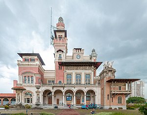
Palácio das Indústrias
Industrial in São Paulo, Brazil
Distance: Approx. 1223 meters
Latitude and longitude: -23.5442,-46.6273
The Palácio das Indústrias is a historical building in São Paulo, under the protection of the Council for the Defense of Historical, Archaeological, Artistic and Tourist Heritage (CONDEPHAAT). It was designed by Domiziano Rossi in conjunction with Ramos de Azevedo and Ricardo Severo and is located in the Parque Dom Pedro II. It is a representative of the Eclectic style and was designed for hosting industrial exhibitions. The first exhibition was held there in 1917.

Immigration Museum of the State of São Paulo
Distance: Approx. 778 meters
Latitude and longitude: -23.5492,-46.6131
The Immigration Museum of the State of São Paulo (Brazilian Portuguese: Museu da Imigração do Estado de São Paulo) is a museum of immigration in the Mooca neighbourhood in east São Paulo, Brazil. It is located in the Immigrant Inn building, which opened in 1887. The "Historical Center of Immigrants" was created in 1986.

Immigrant Inn
Building
Distance: Approx. 791 meters
Latitude and longitude: -23.5495,-46.61278
The Immigrant Inn (Brazilian Portuguese: Hospedaria dos Imigrantes) is a building in São Paulo. Construction started in 1886, and opened in 1887 (before completion), with the first group of immigrants arriving on 5 June 1887, before construction was completed in 1888. It was the main place for new immigrants to stay when arriving in the state of São Paulo at a time when coffee production in Brazil was being expanded and slavery in Brazil had been abolished.
Juventus-Mooca (CPTM)
Metro station of CPTM in the municipy of São Paulo, Brazil
Distance: Approx. 1215 meters
Latitude and longitude: -23.557157,-46.608827
Juventus-Mooca is a train station on CPTM's Line 10-Turquoise. It's located in the city of São Paulo.
Estádio Antarctica Paulista
Distance: Approx. 837 meters
Latitude and longitude: -23.55482557,-46.61183543
The Estádio Antônio Alonso, also known as Estádio Antarctica Paulista or Estádio da Rua da Mooca was an association football stadium in São Paulo, Brazil. Owned by the Companhia Antarctica Paulista, it was used from 1920 to 1943 in matches of the Campeonato Paulista. It is currently the parking lot of the Bavaria Brewery, part of the Ambev group.
Solar da Marquesa de Santos
18th-century manor house in São Paulo, Brazil
Distance: Approx. 1351 meters
Latitude and longitude: -23.54856,-46.63214
The Solar da Marquesa de Santos is a manor house located in central São Paulo, Brazil, that hosts several cultural exhibitions and is currently the headquarters of the Cidade de São Paulo museum. The residence, made of rammed earth blocks, was built around the second half of the 18th century. Between 1834 and 1867, the building served as a home for Domitila de Castro, Marchioness of Santos, who acquired the property from the heiress of Brigadier Joaquim de Moraes Leme after the break in her relations with Pedro I of Brazil.

Catavento Museum
Interactive science museum in São Paulo, Brazil
Distance: Approx. 1276 meters
Latitude and longitude: -23.54416667,-46.62805556
The Catavento Museum is an interactive museum, inaugurated in 2009. It is dedicated to science and its dissemination, and is located in the Palácio das Indústrias ("Palace of the Industries"), in São Paulo, Brazil. The 12,000 square meter space is divided into 4 sections: "Universo" ("Universe"),"Vida" ("Life"), "Engenho" ("Ingenuity") and "Sociedade" ("Society") and has more than 250 installations.

Parque Dom Pedro II
Park in São Paulo, Brazil
Distance: Approx. 831 meters
Latitude and longitude: -23.55055556,-46.6275
Parque Dom Pedro II (Dom Pedro II Park in English) is a park located in the Sé neighborhood of São Paulo, Brazil. It lies on the border between the Historic Center of São Paulo and the Brás neighborhood.
Weather in this IP's area
moderate rain
20 Celsius
21 Celsius
20 Celsius
21 Celsius
1006 hPa
96 %
1006 hPa
924 hPa
10000 meters
5.66 m/s
11.32 m/s
350 degree
40 %
05:16:21
18:24:13


