Country:
 Brazil
Region:
City:
Latitude and Longitude:
Time Zone:
Postal Code:
IP information under different IP Channel
ip-api
Country
Region
City
ASN
Time Zone
ISP
Blacklist
Proxy
Latitude
Longitude
Postal
Route
IPinfo
Country
Region
City
ASN
Time Zone
ISP
Blacklist
Proxy
Latitude
Longitude
Postal
Route
MaxMind
Country
Region
City
ASN
Time Zone
ISP
Blacklist
Proxy
Latitude
Longitude
Postal
Route
Luminati
Country
BRRegion
ma
City
pindaremirim
ASN
Time Zone
America/Fortaleza
ISP
ATEX NET TELECOMUNICACOES LTDA
Latitude
Longitude
Postal
db-ip
Country
Region
City
ASN
Time Zone
ISP
Blacklist
Proxy
Latitude
Longitude
Postal
Route
ipdata
Country
Region
City
ASN
Time Zone
ISP
Blacklist
Proxy
Latitude
Longitude
Postal
Route
Popular places and events near this IP address

Santa Inês
Municipality in Nordeste, Brazil
Distance: Approx. 4987 meters
Latitude and longitude: -3.66888889,-45.38388889
Santa Inês is a municipality in the state of Maranhão in the North-East region of Brazil. The municipality contains a small part of the Baixada Maranhense Environmental Protection Area, a 1,775,035.6 hectares (4,386,208 acres) sustainable use conservation unit created in 1991 that has been a Ramsar Site since 2000. It was emancipated from Pindaré Mirim in 1967.
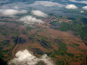
Pindaré-Mirim
Municipality in Nordeste, Brazil
Distance: Approx. 4958 meters
Latitude and longitude: -3.61666667,-45.35
Pindaré-Mirim is a municipality in the state of Maranhão in the Northeast region of Brazil. The municipality contains a small part of the Baixada Maranhense Environmental Protection Area, a 1,775,035.6 hectares (4,386,208 acres) sustainable use conservation unit created in 1991 that has been a Ramsar Site since 2000.
Weather in this IP's area
broken clouds
33 Celsius
35 Celsius
33 Celsius
33 Celsius
1012 hPa
49 %
1012 hPa
1009 hPa
10000 meters
2.18 m/s
3.5 m/s
61 degree
51 %
05:46:49
17:55:12