Country:
 Brazil
Region:
City:
Latitude and Longitude:
Time Zone:
Postal Code:
IP information under different IP Channel
ip-api
Country
Region
City
ASN
Time Zone
ISP
Blacklist
Proxy
Latitude
Longitude
Postal
Route
IPinfo
Country
Region
City
ASN
Time Zone
ISP
Blacklist
Proxy
Latitude
Longitude
Postal
Route
MaxMind
Country
Region
City
ASN
Time Zone
ISP
Blacklist
Proxy
Latitude
Longitude
Postal
Route
Luminati
Country
BRASN
Time Zone
America/Sao_Paulo
ISP
Durand do Brasil Ltda
Latitude
Longitude
Postal
db-ip
Country
Region
City
ASN
Time Zone
ISP
Blacklist
Proxy
Latitude
Longitude
Postal
Route
ipdata
Country
Region
City
ASN
Time Zone
ISP
Blacklist
Proxy
Latitude
Longitude
Postal
Route
Popular places and events near this IP address

Guarulhos
Municipality in Southeast, Brazil
Distance: Approx. 1074 meters
Latitude and longitude: -23.46277778,-46.53277778
Guarulhos (Portuguese pronunciation: [ɡwaˈɾuʎus]) is a Brazilian municipality. It is the second most populous city in the Brazilian state of São Paulo, the 13th most populous city in Brazil, and is also the most populous city in the country that is not a state capital. In the last few years it has outgrown Campinas.

Jaçanã (district of São Paulo)
District of São Paulo, Brazil
Distance: Approx. 4711 meters
Latitude and longitude: -23.466863,-46.579344
Jaçanã (Portuguese pronunciation: [ʒasɐˈnɐ̃]) is a district of the city of São Paulo, Brazil. It constitutes with Tremembé the subprefecture Jaçanã-Tremembé, marking the northern boundaries of the city. Like Parelheiros, most of the area of this borough is rural, although in the southern areas there is an urban area.

Aricanduva River
River in São Paulo state, Brazil
Distance: Approx. 5973 meters
Latitude and longitude: -23.51666667,-46.56666667
The Aricanduva River (in Portuguese: Rio Aricanduva) is a river of São Paulo state in southeastern Brazil.
Baquirivu-Guaçu River
River in Brazil
Distance: Approx. 5275 meters
Latitude and longitude: -23.48333333,-46.48333333
The Baquirivu-Guaçu River is a river of São Paulo state in southeastern Brazil.

Cabuçu de Cima River
River in Brazil
Distance: Approx. 5204 meters
Latitude and longitude: -23.51666667,-46.55
The Cabuçu de Cima River is a river of São Paulo state in southeastern Brazil.

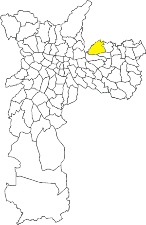
Subprefecture of Jaçanã-Tremembé
Subprefecture in Southeast, Brazil
Distance: Approx. 4654 meters
Latitude and longitude: -23.46583333,-46.57861111
The Subprefecture of Jaçanã-Tremembé is one of 32 subprefectures of the city of São Paulo, Brazil. It comprises two districts: Jaçanã and Tremembé. It's the northernmost subprefecture and largely covered by parts of the Atlantic Forest.
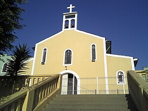
Paróquia Nossa Senhora de Montevirgem e São Luís Gonzaga
Church in São Paulo, Brazil
Distance: Approx. 5547 meters
Latitude and longitude: -23.52222222,-46.5325
Paróquia Nossa Senhora de Montevirgem e São Luiz Gonzaga is a church located in São Paulo, Brazil. The church dates to 1742.
Primeira Igreja Batista em Vila Silvia
Church in São Paulo, Brazil
Distance: Approx. 4516 meters
Latitude and longitude: -23.49722222,-46.49861111
Primeira Igreja Batista em Vila Silvia is a church located in São Paulo, Brazil.
Cangaíba
District of São Paulo, Brazil
Distance: Approx. 3887 meters
Latitude and longitude: -23.507,-46.5285
Cangaíba is one of 96 districts in the city of São Paulo, Brazil.

Engenheiro Goulart (CPTM)
Railway station in São Paulo, Brazil
Distance: Approx. 3176 meters
Latitude and longitude: -23.498056,-46.52
Engenheiro Goulart is a train station on CPTM Lines 12-Sapphire and 13-Jade. The building of Engenheiro Goulart station is located in the same place as the old one, in Avenida Doutor Assis Ribeiro, 169, in the district of Cangaíba, East Side of São Paulo. The current building has more than 15,000 square metres (160,000 sq ft) of area and was officially opened on 4 August 2017, after 3 years of reconstruction.

Guarulhos-CECAP (CPTM)
Railway station in São Paulo, Brazil
Distance: Approx. 4891 meters
Latitude and longitude: -23.448611,-46.493333
Guarulhos-CECAP is a train station on CPTM Line 13-Jade, located in the district of Cecap in Guarulhos. It is located by the Km 3 of Rodovia Hélio Smidt, next to Parque Cecap. It has connection with Guarulhos Road Terminal.

Dona Joaninha
Brazilian steam locomotive
Distance: Approx. 382 meters
Latitude and longitude: -23.47333333,-46.53
Dona Joaninha or Estrada de Ferro Sorocabana 6 is a steam locomotive (with the uncommon 2-6-4 wheel arrangement) that is now on static display in Guarulhos, State of São Paulo, Brazil. Constructed in 1940, it was used to move sugar cane across Brazil until the 1960s. A scrap dealer purchased it around 1976, and it was then put on static display around 2000.
Weather in this IP's area
broken clouds
16 Celsius
16 Celsius
16 Celsius
18 Celsius
1014 hPa
86 %
1014 hPa
929 hPa
10000 meters
2.57 m/s
160 degree
75 %
05:39:08
18:07:41