Country:
 Brazil
Region:
City:
Latitude and Longitude:
Time Zone:
Postal Code:
IP information under different IP Channel
ip-api
Country
Region
City
ASN
Time Zone
ISP
Blacklist
Proxy
Latitude
Longitude
Postal
Route
IPinfo
Country
Region
City
ASN
Time Zone
ISP
Blacklist
Proxy
Latitude
Longitude
Postal
Route
MaxMind
Country
Region
City
ASN
Time Zone
ISP
Blacklist
Proxy
Latitude
Longitude
Postal
Route
Luminati
Country
BRASN
Time Zone
America/Sao_Paulo
ISP
Durand do Brasil Ltda
Latitude
Longitude
Postal
db-ip
Country
Region
City
ASN
Time Zone
ISP
Blacklist
Proxy
Latitude
Longitude
Postal
Route
ipdata
Country
Region
City
ASN
Time Zone
ISP
Blacklist
Proxy
Latitude
Longitude
Postal
Route
Popular places and events near this IP address

São Paulo–Congonhas Airport
Domestic airport in São Paulo, Brazil
Distance: Approx. 1895 meters
Latitude and longitude: -23.62611111,-46.65638889
São Paulo/Congonhas–Deputado Freitas Nobre Airport (IATA: CGH, ICAO: SBSP) Portuguese pronunciation: [kõˈɡõɲɐs] is one of the four commercial airports serving São Paulo, Brazil. The airport is named after the neighborhood where it is located, called Vila Congonhas, property of the descendants of Lucas Antônio Monteiro de Barros (1767–1851), Viscount of Congonhas do Campo, first president of the province of São Paulo after the independence of Brazil in 1822, during the Empire. In turn, the Viscount's domain was named after the plural of a shrub known in Brazil as congonha-do-campo (Luxemburgia polyandra, of the Ochnaceae family).

TAM Airlines Flight 3054
2007 plane crash in São Paulo, Brazil
Distance: Approx. 1039 meters
Latitude and longitude: -23.61972222,-46.66222222
TAM Airlines Flight 3054 (JJ3054/TAM3054) was a regularly scheduled domestic passenger flight operated by TAM Airlines from Porto Alegre to São Paulo, Brazil. On the evening of July 17, 2007, the Airbus A320-233 serving the flight overran runway 35L at São Paulo after touching down during moderate rain and crashed into a nearby TAM Express warehouse adjacent to a Shell gas station. The plane exploded on impact, killing all 187 passengers and crew on board, as well as 12 people on the ground.

Anhembi Morumbi University
Private university in Brazil
Distance: Approx. 1588 meters
Latitude and longitude: -23.6005,-46.6749
Universidade Anhembi Morumbi is a Brazilian private university located in São Paulo and member of the Anima Educação group. Ranked one of the top three private universities in the state of São Paulo, the university is one of the most prestigious in various areas of knowledge such as medicine, engineering, business, communication, gastronomy and fashion design. UAM is also known as the first international university of Brazil.
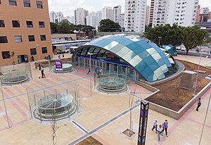
Eucaliptos (São Paulo Metro)
São Paulo Metro station
Distance: Approx. 494 meters
Latitude and longitude: -23.61,-46.668611
Eucaliptos is a metro station on Line 5 (Lilac) of the São Paulo Metro in the Moema district of São Paulo, Brazil.

AACD-Servidor (São Paulo Metro)
São Paulo Metro station
Distance: Approx. 1862 meters
Latitude and longitude: -23.597778,-46.651944
AACD-Servidor is a metro station on Line 5 (Lilac) of the São Paulo Metro in the Moema district of São Paulo, Brazil.

South-Central Zone of São Paulo
Place in São Paulo, Brazil
Distance: Approx. 1732 meters
Latitude and longitude: -23.59805556,-46.65361111
The South-Central Zone is an Administrative Zone of São Paulo, Brazil. According to the 2010 census, it has a population of 731,758 inhabitants. It is a region that is in constant development, with housing neighborhoods more valuable than in the city, such as Klabin, Vila Clementino, and Mirandópolis.

Paróquia Nossa Senhora de Lourdes (São Paulo)
Church in São Paulo, Brazil
Distance: Approx. 1632 meters
Latitude and longitude: -23.61833333,-46.65027778
Paróquia Nossa Senhora de Lourdes is a church located in São Paulo, Brazil. The church was created on 8 December 1939.
Paróquia Santo Ivo (São Paulo)
Church in São Paulo, Brazil
Distance: Approx. 1708 meters
Latitude and longitude: -23.59583333,-46.65888889
Paróquia Santo Ivo is a church located in São Paulo, Brazil.
Christian Reformed Church of Campo Belo
Distance: Approx. 1887 meters
Latitude and longitude: -23.6242,-46.6747
The Christian Reformed Church of Campo Belo, formerly known as Swiss Evangelical Church of São Paulo, is a Reformed Protestant church in Sao Paulo. It was organized in 1958 to serve the Swiss community. The current pastor is Claudio Marra.

Campo Belo (district of São Paulo)
District of São Paulo, Brazil
Distance: Approx. 1496 meters
Latitude and longitude: -23.6217,-46.6719
Campo Belo is one of 96 districts in the city of São Paulo, Brazil. Campo Belo is a district located in the southern region of the municipality of São Paulo, on the northern border of the former municipality of Santo Amaro. In recent years, it has become an area of large middle and upper-middle class buildings.

Vereador José Diniz (São Paulo Metro)
Future monorail station in Sao Paulo, Brazil
Distance: Approx. 1996 meters
Latitude and longitude: -23.622222,-46.678611
Vereador José Diniz will be a monorail station of Line 17-Gold of ViaMobilidade, which is currently under construction, and will connect Line 9-Emerald to Congonhas Airport. Vereador José Diniz station will be placed in the crossing of Avenida Jornalista Roberto Marinho with Avenida Vereador José Diniz. Initially, in the São Paulo Metro expansion plans, Line 17-Gold should be open until 2014, connecting with São Paulo–Morumbi station of Line 4-Yellow, at the time that Morumbi Stadium was considered one of the hosts for 2014 FIFA World Cup.

Aeroporto de Congonhas (São Paulo Metro)
Future railway station in São Paulo, Brazil
Distance: Approx. 1842 meters
Latitude and longitude: -23.626944,-46.661764
Aeroporto de Congonhas will be a monorail station of Line 17-Gold of ViaMobilidade, which is currently under construction, and will connect Line 9-Emerald to Congonhas Airport. Aeroporto de Congonhas station will be located in the crossing of Avenida Washington Luís with Rua Rafael Lório. The station will have a tunnel across Av.
Weather in this IP's area
broken clouds
17 Celsius
17 Celsius
16 Celsius
18 Celsius
1014 hPa
87 %
1014 hPa
927 hPa
10000 meters
3.13 m/s
3.58 m/s
124 degree
75 %
05:39:35
18:08:17