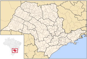
Country:
 Brazil
Region:
City:
Latitude and Longitude:
Time Zone:
Postal Code:
IP information under different IP Channel
ip-api
Country
Region
City
ASN
Time Zone
ISP
Blacklist
Proxy
Latitude
Longitude
Postal
Route
IPinfo
Country
Region
City
ASN
Time Zone
ISP
Blacklist
Proxy
Latitude
Longitude
Postal
Route
MaxMind
Country
Region
City
ASN
Time Zone
ISP
Blacklist
Proxy
Latitude
Longitude
Postal
Route
Luminati
Country
BRASN
Time Zone
America/Sao_Paulo
ISP
Durand do Brasil Ltda
Latitude
Longitude
Postal
db-ip
Country
Region
City
ASN
Time Zone
ISP
Blacklist
Proxy
Latitude
Longitude
Postal
Route
ipdata
Country
Region
City
ASN
Time Zone
ISP
Blacklist
Proxy
Latitude
Longitude
Postal
Route
Popular places and events near this IP address

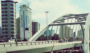
Barueri
Municipality in Southeast, Brazil
Distance: Approx. 5539 meters
Latitude and longitude: -23.51111111,-46.87638889
Barueri (Portuguese pronunciation: [bɐˌɾu.eˈɾi] or [baɾweˈɾi]) is a Brazilian municipality in the State of São Paulo located in the northwestern part of the Metropolitan Region of São Paulo. The population is 276,982 (2020 est.) in an area of 65.70 km2 (25.37 sq mi). Its boundaries are Santana de Parnaíba to the north, Osasco in the east, Carapicuíba in the Southeast, Jandira to the south and southwest, and Itapevi the west.

Carapicuíba
Municipality in São Paulo, Brazil
Distance: Approx. 2511 meters
Latitude and longitude: -23.51916667,-46.83583333
Carapicuíba (Portuguese pronunciation: [kaɾapikuˈibɐ]) is a municipality in the state of São Paulo in Brazil. It is part of the Metropolitan Region of São Paulo. The population is 403,183 (2020 est.) in an area of 34.55 square kilometres (13.34 sq mi).

Alphaville, São Paulo
Real estate development in Brazil
Distance: Approx. 2383 meters
Latitude and longitude: -23.49166667,-46.84527778
Alphaville, Barueri (Portuguese pronunciation: [awfaˈvili]) is an affluent district split between the municipalities of Barueri and Santana de Parnaíba suburbs of São Paulo. The Alphaville district is a real estate and gated community development in Brazil, constituted by a number of business and residential condominium. The name evokes the "first among cities" concept (ville as French for city and alpha being the first letter of Greek alphabet).
Taboão da Serra
Municipality in Southeast, Brazil
Distance: Approx. 4441 meters
Latitude and longitude: -23.53277778,-46.79944444
Taboão da Serra is a municipality in the state of São Paulo in Brazil. It is part of the Metropolitan Region of São Paulo. The population is 293,652 (2020 est.) in an area of 20.39 km².
Cotia River
River in Brazil
Distance: Approx. 3297 meters
Latitude and longitude: -23.51666667,-46.85
The Cotia River is a river of São Paulo state in southeastern Brazil.
CDT da Anhanguera
Distance: Approx. 5414 meters
Latitude and longitude: -23.47555556,-46.7775
The Centro de Televisão da Anhanguera, popularly known as CDT da Anhanguera, is the second largest center of television production in Brazil and is the headquarters of the Brazilian TV company SBT. The complex is second only to the Estúdios Globo of TV Globo, located in Rio de Janeiro. The large complex was inaugurated in 1996 by Silvio Santos and it is located in the city of Osasco within the Greater São Paulo metro area. It concentrates all of the activity of SBT in a single facility.
Tamboré Biological Reserve
Distance: Approx. 5991 meters
Latitude and longitude: -23.448468,-46.841899
Tamboré Biological Reserve (Portuguese: Reserva Biológica Tamboré) is a municipal biological reserve in greater São Paulo, Brazil.
Ginásio José Corrêa
Indoor sporting arena in São Paulo, Brazil
Distance: Approx. 4561 meters
Latitude and longitude: -23.50722222,-46.8675
Ginásio Poliesportivo José Corrêa is an indoor sporting arena that is located in Barueri, São Paulo, Brazil. The capacity of the arena is 5,000 people for basketball and volleyball games.
Osasco
Municipality in Southeast, Brazil
Distance: Approx. 4907 meters
Latitude and longitude: -23.53277778,-46.79194444
Osasco (Portuguese pronunciation: [oˈzasku]) is a municipality in São Paulo State, Brazil, located in the Greater São Paulo area and ranking 5th in population among São Paulo municipalities. According to the IBGE 2015, Osasco currently has the 9th highest gross domestic product in Brazil, and the 2nd largest in the State of São Paulo. The population is 699,944 (2020 est.) in an area of 64.95 km2.
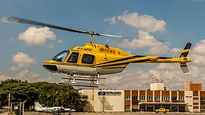
2019 São Paulo helicopter crash
Distance: Approx. 6486 meters
Latitude and longitude: -23.451989,-46.786984
On 11 February 2019, a Bell 206B helicopter crashed while trying to land on the Rodoanel Mário Covas highway, following an unspecified malfunction. Among the victims was journalist Ricardo Boechat. The pilot, Ronaldo Quatrucci, was also killed and one person on the ground was injured.

Comandante Sampaio (CPTM)
Railway station in São Paulo, Brazil
Distance: Approx. 4077 meters
Latitude and longitude: -23.525756,-46.795637
Comandante Sampaio is a rail station belonging to ViaMobilidade Line 8-Diamond, located in the city of Osasco, in the Km 18 borough.

Quitaúna (CPTM)
Railway station in São Paulo, Brazil
Distance: Approx. 3081 meters
Latitude and longitude: -23.522785,-46.807112
Quitaúna is a train station, belonging to ViaMobilidade Line 8-Diamond, located in the municipality of Osasco.
Weather in this IP's area
scattered clouds
17 Celsius
18 Celsius
16 Celsius
18 Celsius
1014 hPa
91 %
1014 hPa
929 hPa
10000 meters
3.84 m/s
6.11 m/s
137 degree
48 %
05:40:16
18:08:51