Country:
 Brazil
Region:
City:
Latitude and Longitude:
Time Zone:
Postal Code:
IP information under different IP Channel
ip-api
Country
Region
City
ASN
Time Zone
ISP
Blacklist
Proxy
Latitude
Longitude
Postal
Route
IPinfo
Country
Region
City
ASN
Time Zone
ISP
Blacklist
Proxy
Latitude
Longitude
Postal
Route
MaxMind
Country
Region
City
ASN
Time Zone
ISP
Blacklist
Proxy
Latitude
Longitude
Postal
Route
Luminati
Country
BRASN
Time Zone
America/Sao_Paulo
ISP
Durand do Brasil Ltda
Latitude
Longitude
Postal
db-ip
Country
Region
City
ASN
Time Zone
ISP
Blacklist
Proxy
Latitude
Longitude
Postal
Route
ipdata
Country
Region
City
ASN
Time Zone
ISP
Blacklist
Proxy
Latitude
Longitude
Postal
Route
Popular places and events near this IP address

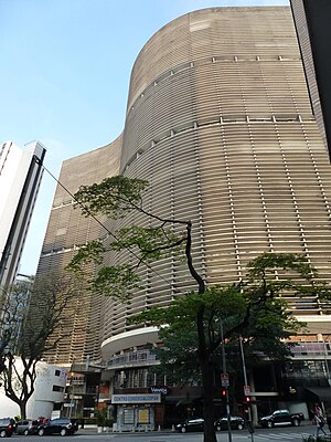
Edifício Itália
Skyscraper in Centre, São Paulo
Distance: Approx. 147 meters
Latitude and longitude: -23.54555556,-46.64361111
Edifício Itália (Portuguese for "Italy Building") (whose official name is Circolo Italiano) is a 165 m (541 ft) tall 46-story skyscraper located in the República district, Central Zone of São Paulo, Brazil. Built from 1956 to 1965, it has a rooftop observation deck, open for tourists. Edifício Itália was designed by Brazilian architect Franz Heep.

Theatro Municipal (São Paulo)
Opera house in Centro, São Paulo
Distance: Approx. 371 meters
Latitude and longitude: -23.54527778,-46.63861111
Municipal Theatre of São Paulo is a theatre in São Paulo, Brazil. It is regarded as one of the landmarks of the city, significant both for its architectural value as well as for its historical importance, having been the venue for the Week of Modern Art in 1922, which revolutionised the arts in Brazil. The building now houses the São Paulo Municipal Symphonic Orchestra, the Coral Lírico (Lyric Choir) and the City Ballet of São Paulo.
Edifício Copan
Skyscraper in São Paulo, Brazil
Distance: Approx. 240 meters
Latitude and longitude: -23.54661667,-46.644375
The Edifício Copan (Copan Building), or just Copan, is one of the most important and emblematic buildings in the city of São Paulo, located at number 200 Avenida Ipiranga, in the city center, and was inaugurated in 1966. It is one of the symbols of modern Brazilian architecture, designed by architect Oscar Niemeyer with structural design by engineer Joaquim Cardozo, aiming to celebrate the Fourth Centenary of the city of São Paulo. The work, however, only began in 1957, with some changes and carried out with the help of Carlos Lemos.
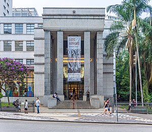
Mário de Andrade Library
Library in São Paulo, Brazil
Distance: Approx. 215 meters
Latitude and longitude: -23.5477,-46.6418
The Mário de Andrade Library (in Portuguese: Biblioteca Mário de Andrade; BMA) is the largest public library in the city of São Paulo, Brazil. Founded in 1925, with a donation of holdings by the library of the city's Câmara Municipal, it became one of the most important cultural institutions in Brazil, as well as one of the leading research libraries in the country. It is named in honor of Mário de Andrade, one of the founders of Brazilian modernism.
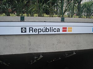
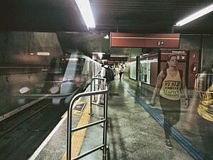
República (São Paulo Metro)
São Paulo Metro station
Distance: Approx. 201 meters
Latitude and longitude: -23.544081,-46.642799
República is a metro station located in the República district, in the center zone of São Paulo. The stations connects the lines 3-Red, operated by Companhia do Metropolitano de São Paulo, and 4-Yellow, operated by ViaQuatro.
Anhangabaú (São Paulo Metro)
São Paulo Metro station
Distance: Approx. 375 meters
Latitude and longitude: -23.547917,-46.639345
Anhangabaú is a station on Line 3 (Red) of the São Paulo Metro.
Teatro Paramount
Theater in São Paulo, Brazil
Distance: Approx. 379 meters
Latitude and longitude: -23.54666667,-46.63861111
Teatro Renault (English: Renault Theater), also known as Teatro Paramount (Paramount Theater) and Teatro Abril (Abril Theater), is located on Brigadeiro Luís Antônio Avenue, in the Brazilian city of São Paulo. It opened in 1929, burned down in 1969 and reopened in 2001.
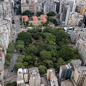
Praça da República (São Paulo)
Park and public square in São Paulo, Brazil
Distance: Approx. 302 meters
Latitude and longitude: -23.5431,-46.6425
Praça da República (Portuguese: Square of the Republic) is a park and public square in the República neighborhood of São Paulo, Brazil. The park covers several city blocks between Rua Pedro Américo, Rua Vinte e Quatro de Maio, Avenida Ipiranga, and Avenida São João in the historic center of the city. Praça da República had many names before 1889, including Largo dos Curros, Largo da Palha, Praça das Milícias, Largo Sete de Abril, and Praça 15 de Novembro.
Escola da Cidade
Private architecture school in Sao Paulo, Brazil
Distance: Approx. 328 meters
Latitude and longitude: -23.54486111,-46.64525
Escola da Cidade (lit. City School) is a private, not-for-profit institution of higher learning in São Paulo, Brazil. Established in 2001, it offers bachelor's degree and postgraduate programs in architecture and urban planning, as well as non-degree courses in architecture, urbanism, design, and related disciplines.

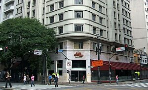
Alexandre Mackenzie Building
Building in São Paulo , Brazil
Distance: Approx. 379 meters
Latitude and longitude: -23.54666667,-46.63861111
The Alexandre Mackenzie Building (Portuguese: Edifício Alexandre Mackenzie), also known as the Light Building (Prédio da Light), is a construction located in the central area of the city of São Paulo, between the intersection of Coronel Xavier de Toledo Street and the Viaduto do Chá, designed by the Americans Preston and Curtis and executed by Severo, Villares & Cia. Ltda. It was the headquarters of the São Paulo Tramway, Light and Power Company and later of the former state-owned Eletropaulo.
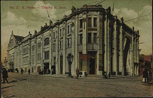
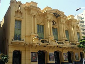
São José Theater
Theater in São Paulo, Brazil
Distance: Approx. 379 meters
Latitude and longitude: -23.54666667,-46.63861111
The São José Theater (Portuguese: Theatro São José) was an important venue located in Largo São Gonçalo, now Doutor João Mendes Square, in the Brazilian city of São Paulo. Inaugurated on September 4, 1864, its first premises accommodated 1,200 people. In 1898, a fire destroyed the building and a new theater was erected next to the Viaduto do Chá.
Bar Brahma
A bar in São Paulo, Brazil
Distance: Approx. 310 meters
Latitude and longitude: -23.54472222,-46.645
Bar Brahma is a traditional bar located in the city center of São Paulo, Brazil. The bar was founded in 1948 by German immigrant Henrique Hillebrecht. The bar soon became a meeting place for important personalities from the academic and political circles of the city of São Paulo, such as former mayor Jânio Quadros, former governor Adhemar de Barros and professor and former president Fernando Henrique Cardoso, as well as being a stronghold for the artistic world of São Paulo, bringing together musicians such as Adoniran Barbosa, Orlando Silva, Ary Barroso, Vicente Celestino, among others.
Weather in this IP's area
broken clouds
17 Celsius
17 Celsius
16 Celsius
17 Celsius
1014 hPa
86 %
1014 hPa
925 hPa
10000 meters
3.6 m/s
150 degree
75 %
05:39:31
18:08:09